
 |
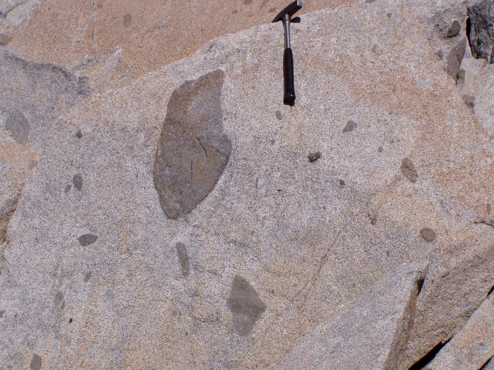
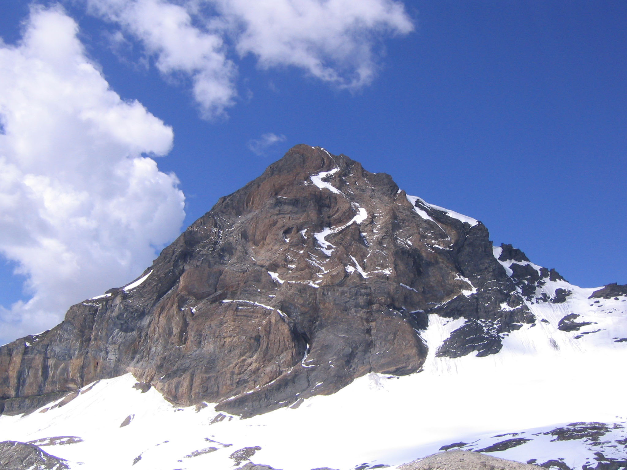
Mafic enclaves in the Lago della Vacca tonalite in the southernmost part of the 42 million years old Adamello intrusion (province of Brescia, northern Italy). This intrusion was formed by sequential intrusion of melt batches over ca. 300'000 years, which were all delivered from the same volcanic center (Schoene et al. 2012). The result is a so-called "magma balloon" that gets younger from its rims inwards.
Micro-granular enclaves are common in "granitic" plutons and are witnesses of the periodic injection of mafic magmas into crustal reservoirs where felsic magmas are stored. The intensity of deformation recorded by enclaves distributed in a pluton can be used to quantify the evolution of temperature in a magmatic body during its assemblage. This provides constraints on the total duration of the magmatic episode responsible for the assemblage of a body of magma in the crust (Caricchi et al., 2012). The Adamello batholith has been the focus of a nation-wide research program (ProDoc 4D Adamello), which investigates timescale, modes and processes of melt emplacement in the crust (http://www.unil.ch/img/page72459_en.html) References: Click on the picture for an enlarged version of this photograph (747 Kb) |
|
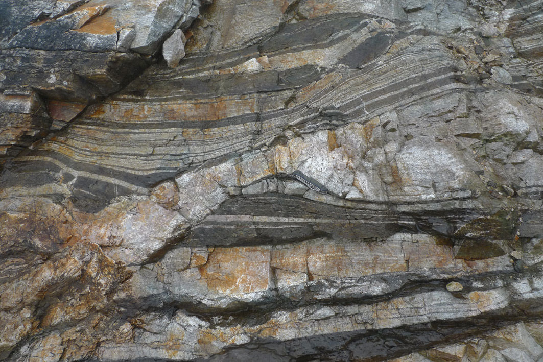 |
Paragneisses near Berlin (Santander Massif, Colombia, South America).
Banded gneisses of meta-sedimentary origin that are crosscut by local anatectic mobilisates. The leucocratic band of the gneiss appears to crosscut the melanocratic band, the melting is therefore younger. The composition of the crosscutting band is, however, similar to the parallel leucocratic bands. The age of the metamorphism is not currently known but is inferred to be Precambrian. However, there is Evidence for magmatism of Ordovician and Jurassic age, as well as for crustal melting and formation of migmatites in the Triassic. The investigation of the geological evolution of the Andean continental margin is part of ongoing PhD research at the Department of Mineralogy. Click on the picture for an enlarged version of this photograph (240 Kb) |
|
 |
Future Developments in Modeling and Monitoring of Volcanic Ash Clouds The first IAVCEI-WMO workshop on Ash Dispersal Forecast and Civil Aviation (Geneva, 18-20 October 2010) was organized under the sponsorship of the Faculty of Sciences of the University of Geneva with the main objective of revising our current approach to dispersal forecasting and provide a more robust and reliable response to the social needs based on the experience of the recent Eyjafjallajökull eruption in Iceland. More details in: Bonadonna C., Folch, A, Loughlin S. (2011) Future Developments in Modeling and Monitoring of Volcanic Ash Clouds. EOS Transactions, American Geophysical Union, Vol. 92, No. 10, page 85 Large-Scale Experiments on Volcanic Processes Click on the picture for an enlarged version of this photograph (1008 Kb) |
|
 |
The photograph shows chunks of Jurassic volcano-clastic sediment incorporated into the Ilo Batholith, in coastal southern Peru. The Ilo Batholith extends for approximately 150 km along the southern Peruvian coast and is a remnant of Bajocian-Bathonian plutonism (dated at around 165 million years) that can be found near the town of Ilo. The emplacement of the Ilo Batholith into the upper crust is partly coeval with deposition of the surrounding sediments, which can be explained by the association of these rocks in time and space within a series of grabens in an extensional tectonic context. The extension began possibly as early as the latest Triassic and continued throughout most of the Jurassic. The middle Jurassic Ilo Batholith represents the culmination of this period of extension at the onset of modern Andean orogenic dynamics.
Click on the picture for an enlarged version of this photograph (1358 Kb) Ongoing research at the Department of Mineralogy aims at unravelling the pre-Andean evolution of the South American active margin in Peru, using geochemical and geochronological tools, on rocks of both the coastal and the eastern Cordillera. |
|
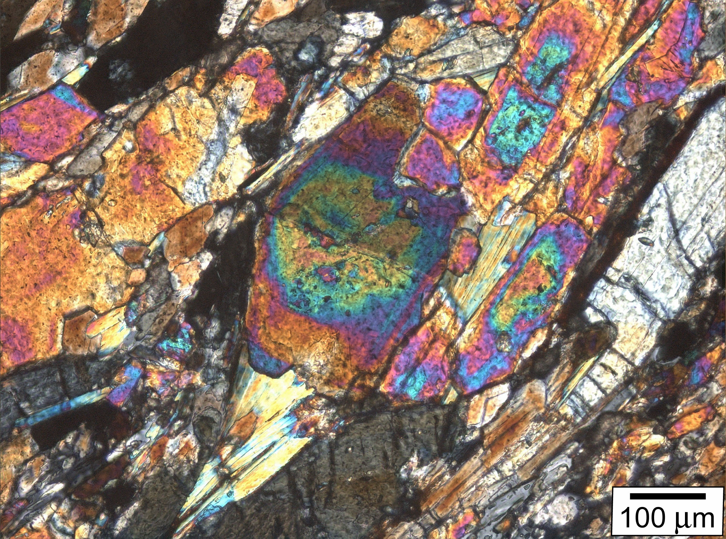 |
Zoned epidote from a massive blueschist facies metabasite from the Ile
de Groix (Brittany, France) displaying large pseudomorphs after
lawsonite. The Fe-rich core and Al-rich rim represent two growth
generations which are also well distinguished based on the REE
signatures. Epidote generally shows a slight fractionation of LREE
compared to HREE. Epidote core formed in equilibrium with lawsonite
during the prograde metamorphism. It is depleted in REE, mainly
retained by lawsonite and by a former generation of epidote. Epidote
rims formed during lawsonite breakdown and inherited the released REE.
The REE signature of epidote is related to the presence or absence of
REE-rich minerals (mainly lawsonite, LREE-rich apatite and HREE-rich
titanite) in the metamorphic mineral assemblage and changes along the
metamorphic P-T path.
Click on the picture for an enlarged version of this photograph (1053 Kb) Afife El Korh, Schmidt, S. Th.,
Ulianov, A. & Potel, S. (2009). Trace Element Partitioning in HP-LT
Metamorphic Assemblages during Subduction-related Metamorphism, Ile de
Groix, France: a Detailed LA-ICPMS Study. Journal of Petrology 50 (6),
1107-1148. doi:10.1093/petrology/egp034 |
|
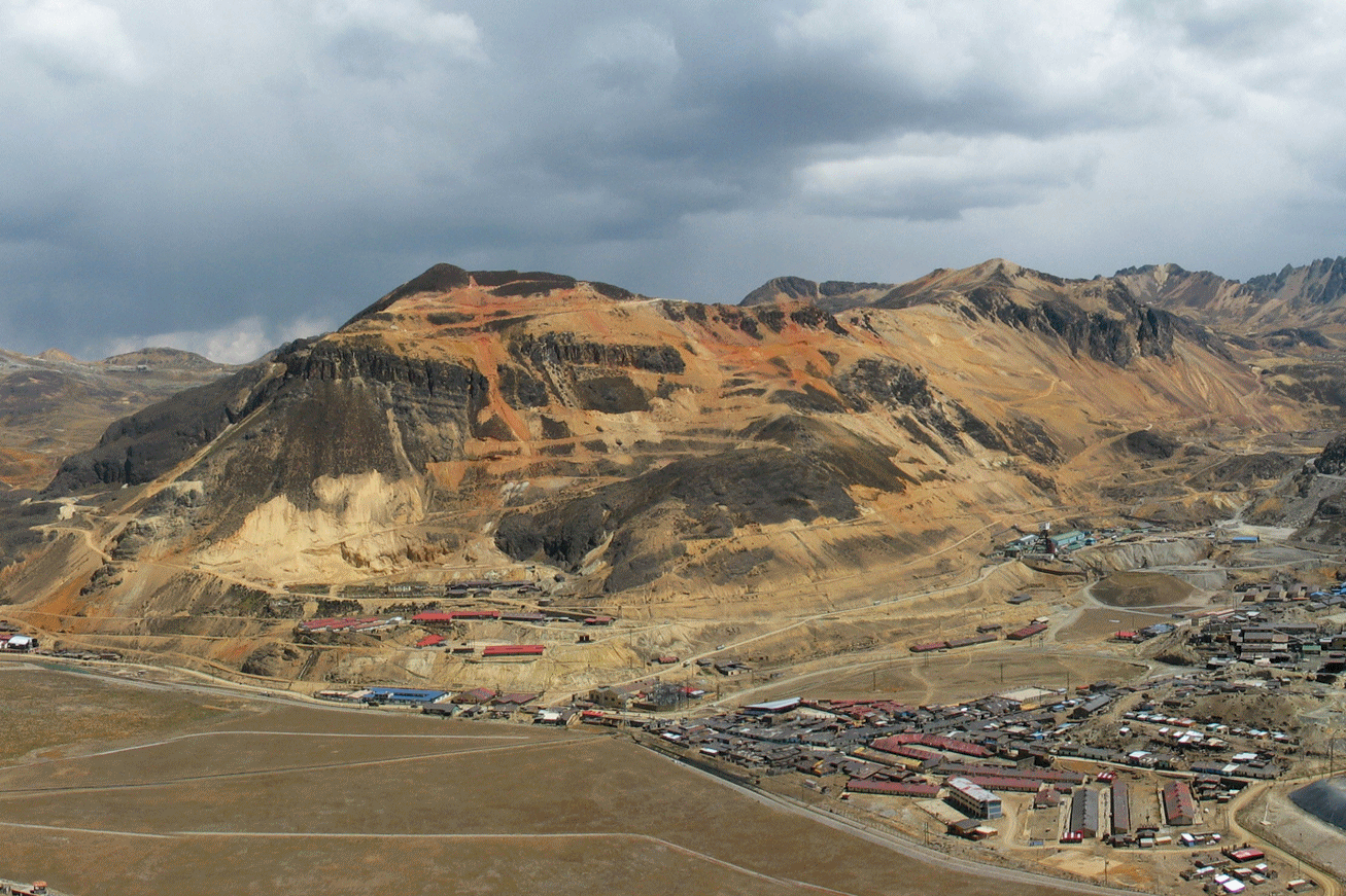 |
The world-class mining district of Morococha covers an area of about 70 km2 in the Western Cordillera of central Peru and is part of the Miocene polymetallic belt. The central part of the district is dominated by the giant Toromocho porphyry Cu-Mo deposit. Multiple late-Miocene porphyry stocks intruded Permian, Triassic-Jurassic and Late-Cretaceous sedimentary carbonate and volcano-sedimentary formations, as well as large mid-Miocene barren intrusions. Epithermal polymetallic replacement bodies and veins overprint porphyry mineralization and skarns related to the subvolcanic Miocene intrusions. An ongoing Geneva research project in cooperation with several mining companies aims to unravel the ore formation history of the district. A key point of the project is to understand how in relatively short period of time (< 2 My) ore formation changed from porphyry ( 500°C, several km depth) to epithermal conditions (<300 °C, near surface environment).
Click on the picture for an enlarged version of this photograph (572 Kb) More on Morococha district: K. Kouzmanov - H. Catchpole |
|
 |
Click on the picture for original version of this photograph (1885 Kb) | |
 |
Galeanella panticae, Upper Triassic (228-199 Ma), benthic foraminifer from the reefal limestones of the Panormide Platform, Cozzo di Lupo, Sicily, Italy. Kingdom Protista (one-celled eukaryotes) includes the order Foraminiferida. Similar to amoeboid organisms in cell structure, the foraminifera differ in having granular rhizopodia and elongate filopodia that emerge from the cell body. Foraminifers are covered with an organic test that varies from a simple single chamber with an aperture, to a complex, multichambered, perforate, calcitic wall, to an agglomeration of mineral grains embedded in the organic test. The foraminifera are divided into two primary groups based on their mode of life, planktonic (marine floaters), and benthic (sea floor dwellers). Benthic foraminifera display a variety of life cycles that include sexual and asexual phases and produce megalospheric and microspheric generations. The length of an individual's life can range from a few weeks to up to 5 years. Benthic foraminifera occupy a wide range of marine environments, from brackish estuaries to the deep ocean basins, and occur at all latitudes. Geologists tend to call them "forams" to save time. Forams are a very important group of indicator fossils because they occupy rocks from Cambrian age to the modern environment, covering more than 500 million years of geologic time. And because the various foram species live in very particular environments, fossil forams are strong clues to the environments of ancient times-deep or shallow waters, warm or cold places, and so on. Benthic forams can be used as biostratigraphic indicators. Larger benthic forams are very useful biostratigraphically in Late Palaeozoic and Early Mesozoic stratigraphy. Oil drilling operations typically have a palaeontologist nearby, ready to look at the forams under the microscope. That's how important they are for dating and characterizing rocks. Click on the picture for an enlarged version of this photograph (478 Kb) |
|
 |
Text: Dyke of picritic basalt intruding into layered dolomite in the contact
aureole of the Val Fredda leucotonalite, Southern Adamello (NW Italy). The
banded dolomite has been folded during a regional tectonic phase and further
compressed and recrystallized during emplacement of the magmatic melts 41 Ma
ago. The picritic basalt represents the most pristine mantle melt involved
in the plutonism of the Southern Adamello. Ongoing research at the
Department of Mineralogy studies the timing of magma emplacement as well as
the rates of mingling geochemically different magma batches and
crystallizing rock-forming mineral phases.
Click on the picture for an enlarged version of this photograph (666 Kb) |
|
 |
Sediments straddling the Triassic-Jurassic boundary along a fresh road cut in Utcubamba valley, northern Peru. The Triassic-Jurassic boundary is marking the second biggest mass extinction event in Earth s history, which is thought to be the result of significant climate deterioration after a 500 ky period of massive volcanism in the Central Atlantic Magmatic Province. The exact age of the Triassic-Jurassic boundary (201.58 ± 0.17 Ma) has been precisely dated by U-Pb zircon dating techniques in the frame of a research project at the Department of Mineralogy. This new, precise and accurate age determinations provide evidence that basalt flows in eastern United States and Canada are possibly the smoking gun of this mass extinction. The globally disturbed marine ecosystems took 2 million years to recover and get back to the pre-extinction faunal diversity.
Click on the picture for an enlarged version of this photograph (443 Kb) |
|
 |
3 février 2008: "La Licorne", bateau de recherche de l'Institut F.A. Forel en train d'acquérir des données bathymétriques (mesures de profondeur du lac) par sonar multi-faisceau au large du delta du Rhône sur le Léman. Ce projet de recherche, financé par l'Office fédéral de topographie, est réalisé en collaboration avec le Centre fédéral de recherches aquatiques, EAWAG et le Centre Renard de Géologie Marine de l'Université de Gent.
3 February 2008: The research boat of Institute F.A. Forel, collecting multi-beam water depth data of the Rhone delta on Lake Geneva. This is a research project sponsored by SWISSTOPO, in collaboration with the Swiss Federal Institute of Aquatic Science and Technology (EAWAG) and the Renard Centre of Marine Geology of University of Ghent. Click on the picture for an enlarged version of this photograph (454 Kb) |
|
 |
Mike Dungan, Carolina Rodriguez
and Daniel Selles are convening a GSA Field Conference on Continental
Arc Volcanism at the Tatara-San Pedro Complex, Chile (February
3-13, 2007) http://www.geosociety.org/fieldForums/07chile.htm.
The Field Conference takes place immediately after the State of the
Arc (SOTA) meeting at Termas Puyehue, Chile (January 28-February 2,
2007) also convened by Mike Dungan. http://sota2007.fiu.edu/index.htm
Photograph @: Mike Dungan (February 2006) Click on the picture for an enlarged version of this photograph (177 Kb) |
|
 |
Lacustrine sediments from Lago Cardiel
(central Patagonia, Argentina) are among the best studied climate records
of the Southern Hemisphere.
Photograph ©: A. Gilli Click on the picture for an enlarged version of this photograph (150 Kb) More on limnology
research: Institut Forel |
|
 |
Nevado
Huaguruncho (5723 m) in the Cordillera Oriental of Peru. Photo taken
from the gold district of Huachón during the 2005 field trip of the SEG student chapters
of the University of Geneva and the ETH Zürich
Photograph ©: R. Moritz (1.10.2005) Click on the picture for an enlarged version of this photograph (84 Kb) |
|
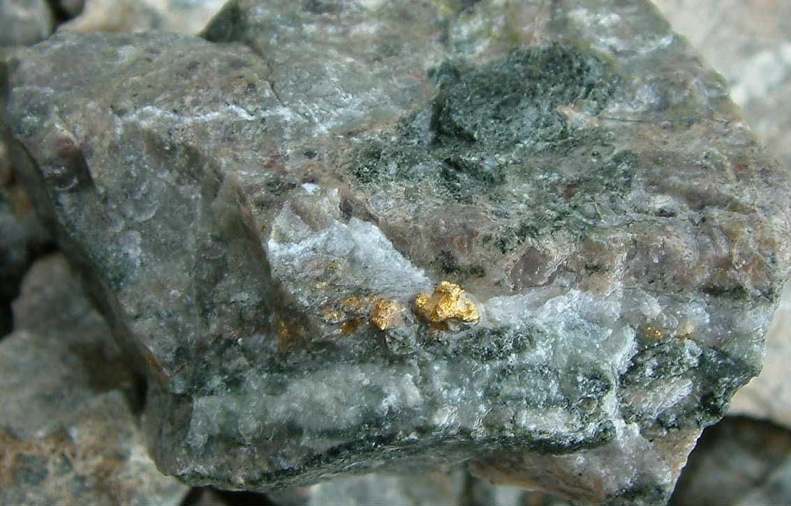 |
Native gold (yellow) in a quartz
vein (white and light grey) with
hematite disseminations (brown), garnet (dark green) ,and pyroxene
(light green) in the Nambija skarn, Campanillas Mine, Ecuador.
Striking feature in this oxidized gold skarn are the high gold grades
and the low metal and sulfur contents. Width of photo: 3.2 cm.
Photograph ©: L. Fontboté Click on the picture for an enlarged version of this photograph. Width of photo: 6 cm (105 Kb) |
|
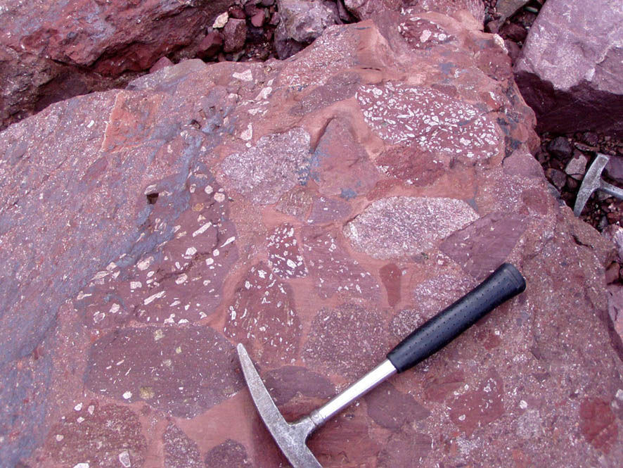 |
Volcanic breccia from the early
Jurassic peralkaline Allinccápac formation (Eastern Cordillera,
southeastern Peru), consisting of nepheline-bearing rhyolite clasts
in a volcanic matrix. This peralkaline volcanic formation marks the
end of a protracted period of lithospheric thinning and extension,
forming the several km-thick red bed formations of the Mitu Group in
the area of Cuzco - Lake Titicaca. The reconstruction of Paleozoic
and Mesozoic geodynamics of the Gondwana margin in present-day Peru
is the topic of research projects at the Department of Mineralogy.
Photograph ©: U. Schaltegger Click on the picture for an enlarged version of this photograph (182 Kb) |
|
 |
The Earth’s largest mass extinction
event occurred at the Permian-Triassic boundary, ca. 252 million years
ago. 95% of all living species, including ammonoids (picture shows
Eodanubites zyunensis from the Spathian, Lower Triassic) became extinct
due to a major climatic crisis. The dynamics of the biotic recovery
of ammonoids during the 20 million years following the extinction event
have been studied in detail in a section of Lower Triassic carbonates
in Southern China. For absolute age determination and calibration of
biostratigraphic ammoniod zones highly-sophisticated U-Pb dating techniques
are employed. Calibration of ammonite-bearing carbonates by dating
single grains of zircon (ZrSiO4) in interlayered
volcanic ash beds reveals that the extinction event at the Permian/Triassic
boundary was followed by a series of climatic crises. Another major
biotic crisis at the Smithian/Spathian boundary (ca. 250 Ma ago) may
have been related to massive input of CO2 from large volcanic eruptions
in Siberia into the atmosphere.
Photograph ©: H. Bucher, (Univ. of Zürich) and U. Schaltegger Click on the picture for an enlarged version of this photograph (579 Kb) |
|
 |
Mingling of microdioritic and granodioritic
magmas in the calc-alkaline Pataz Batholith of the northern Peruvian
Cordillera Oriental. The batholith was emplaced as a part of the continental
magmatic arc developed along the western Gondwanan margin during mid-to
Upper Carboniferous (ca. 336 and 325 Ma). Following a considerable
time lag (c.a. 10-12 Ma), the intrusive rocks were infiltrated by SiO2-rich,
ore-bearing fluids, resulting in a mesothermal, so-called, "orogenic” Au-Ag
deposit belt. Geochemical, geochronological, metallogenic, and geodynamic
aspects of this magmatic pulse are currently under investigation.
Photograph ©: A. Miskovic Click on the picture for an enlarged version of this photograph (160 Kb) |
|
 |
Ferdenrothorn,
3180 m (Loetschental Mountains between the Bernese Oberland and Valais).
Overturned folds in the Liassic limestone and marls of the Helvetic
Doldenhorn Nappe. We carry out every year a first year field course
in this region. For more information contact R. Martini at the Department
of Geology and Paleontology, University of Geneva.
Photograph ©: R. Martini Click on the picture for an enlarged version of this photograph (392 Kb) |
|
 |
Columnar jointing at Studen Kladenets,
near dam on Arda Rica, Rhodopes, Bulgaria. High-K andsesites younger
than 30.2 ma (Singer and Marchev, 2001). This outrop was visited during
the Geneva SEG student chapter field trip in Bulgaria, 6-14 May 2003.
Width of photo: 10 m.
Photograph ©: Lluís Fontboté (May 2003) Click on the picture for an enlarged version of this photograph (612 Kb) |
|
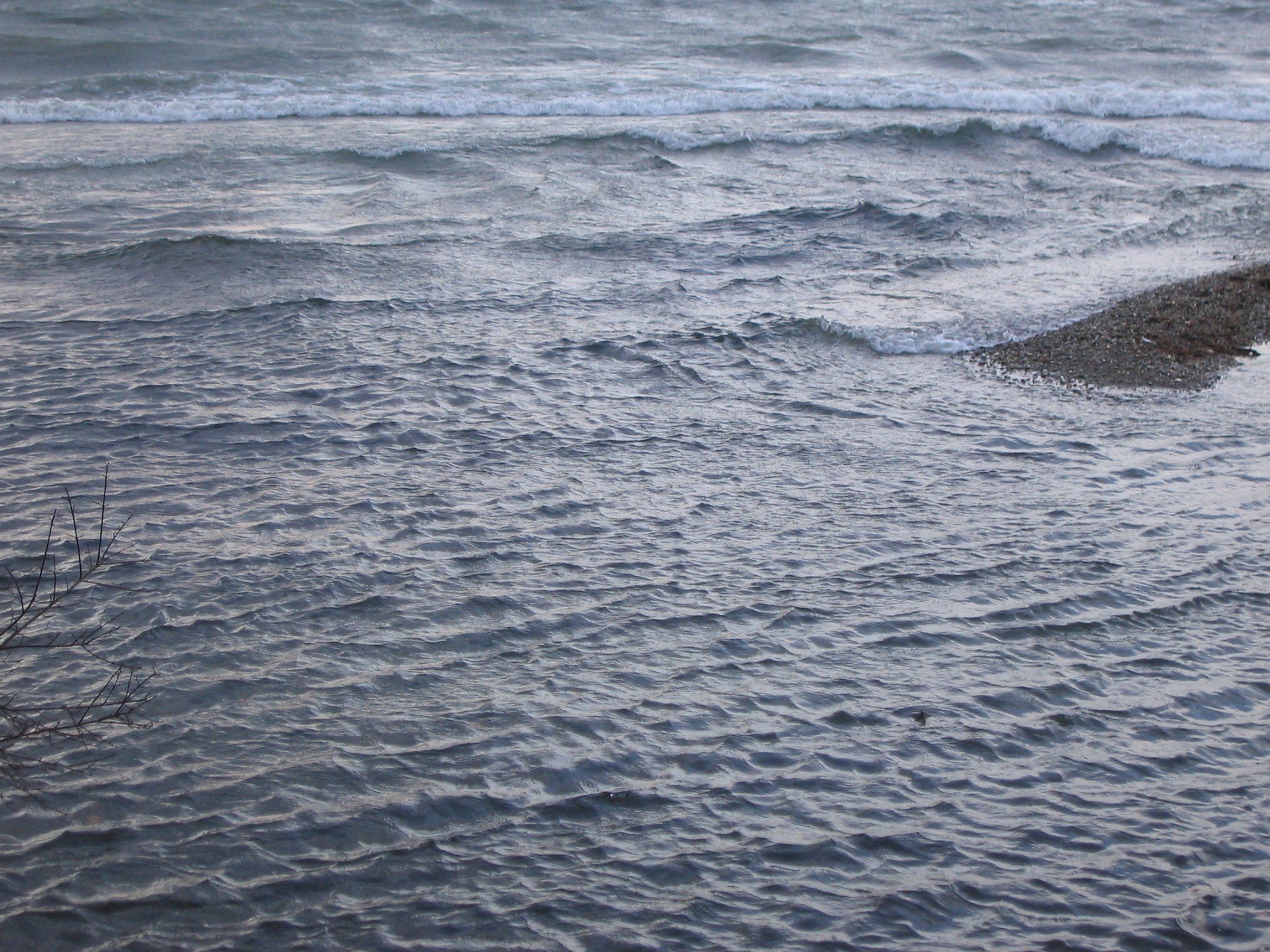 |
Wawes braking on a bar of the
Lake Leman shore
Photograph ©: Walter Wildi, Versoix, parc de la Becassine, 31/12/2003 Click on the picture for an enlarged version of this photograph (699 Kb). Researchers from the Institut F.-A. Forel have just edited an special issue of the journal Lakes and Reservoirs (Research and Management Vol. 9/1, March 2004), in honour of Honorary Professor Richard Linn Thomas, former associate Professor of the Institut F.-A. Forel. Contents and abstracts of these issue are free available
under More on limnologeological research at the Institut F.-A. Forel |
|
 |
Stockwork of the Volcanic Hosted
Massive Sulfide (VHMS) San Miguel in the Riotinto Belt, Spain.
Photograph ©: Lluís Fontboté, May 1997. Click on the picture for an enlarged version of this photograph (320 Kb) |
|
![]()
Send comments on page to ![]()