Fossil rivers of the Sahara tell of the threat of warming
A UNIGE-led team has studied the fossil rivers of the Egyptian Sahara to reconstruct the region’s rainfall rates that led to a major migration of people away from the Nile valley 10,000 years ago.
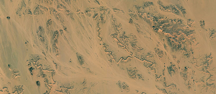
A satellite image shows the morphologies of fossil rivers in southern Egypt. This study shows that these rivers were intensely active during the African wet period. © Esri World Imagery
Why did the people living near the Nile river migrate to central Egypt 10,000 years ago, when the Egyptian Sahara was still green? Geologists led by the University of Geneva (UNIGE), Switzerland, have studied the fossil rivers north of Lake Nasser in Egypt in order to reconstruct the palaeo-hydrology of the region and to determine the rainfall rate of this African humid period. They found that following a rapid temperature increase of about 7°C, the frequency of heavy rainfall events increased fourfold, increasing river flooding and forcing riverine populations to migrate to the center of the country. These results, to be read in the journal Quaternary Science Reviews, highlight the increase in extreme weather episodes in the event of global warming.
Africa experienced a wet period between 14,800 and 5,500 BC, characterized by a still green Sahara. However, this region north of Lake Nasser in Egypt is now arid, leaving only fossilized rivers as traces of this green past. “These rivers are essential for reconstructing past climates, as they allow us to determine the quantities of flowing water at the time, as well as the quantities and frequencies of rainfall”, explains Abdallah Zaki, a PhD researcher in the Department of Earth Sciences at the UNIGE Faculty of Science and first author of the study.
Reconstructing river discharge to obtain precipitation rates
To reconstruct the palaeo-hydrology of a region, it is first necessary to measure the pebbles in the fossil rivers. “Large pebbles indicate a high water discharge, capable of transporting them, as do the depth and width of the river, which make it possible to assess the water discharge, for instance in units of cubic meters per second”, says Sébastien Castelltort, associate professor in the Department of Earth Sciences and final author of the study. The second step is to find out the surface area of the drainage basin, i.e. the area that connects the water upstream to the river. “By combining these two figures, we obtain the precipitation rate responsible for transporting the studied sediments”, continues the Geneva researcher.
To find the age of the rivers, the scientists use two different techniques. The first, carried out in collaboration with ETH Zurich, uses carbon-14 dating of the organic matter that fills the fossilized rivers. The second, called Optically Stimulated Luminescence and carried out with specialists from the University of Lausanne, consists of measuring the luminescence of quartz to obtain the age of the sediment deposit.
A sharp increase in intense rainfall
The scientists carried out this work on six rivers in the region and confirmed that the rivers were mainly active between 13,000 and 5,000 BC, i.e. at the height of the African wet period. “But what is particularly interesting is that our study shows that the rainfall was very intense, with rates of 55-80 mm per hour, and that such rainfall events were 3 to 4 times more frequent than before the African humid period, which is an enormous climate perturbation”, says Abdallah Zaki.
Indeed, the annual rainfall rate alone does not reflect the intensity of the rains, and therefore the consequences. “If we take London as an example, we have the impression that it rains all the time”, illustrates Sébastien Castelltort. “However, London sees an average of 680 mm of rain per year, compared to about 1400 mm in Geneva, which is more than twice as much!” It’s simply that in London, rainfall is spread out over the whole year, whereas it is more concentrated in Geneva.
An explanation for the strong migration of the Nile populations
The results obtained by the geologists, i.e. this sudden increase in the frequency of intense rainfall events, provide an explanation for the strong migration of the region’s riparian (living near the river) populations towards the center of the territory at that time, as observed by the archaeologists. “Indeed, the violent flooding of the rivers increased, making the banks inhospitable”, confirms Abdallah Zaki.
This fourfold increase in violent rainfall also coincides with a 7°C increase in temperature in the region. “This study thus provides us with a historical lesson told by the rocks on how the Earth system behaves in the event of rapid global warming”, says Sébastien Castelltort. Understanding the distribution of precipitation over the year will become a key issue in risk prevention today, because in a period of global warming, these risks will also increase in the near future. “What happened in Germany this summer will certainly become more common”, he concludes.