Projects
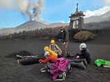
Field characterization of tephra deposits
Detailed stratigraphic investigations of past and recent eruptions are required to best understand and interpret explosive volcanism. In fact, tephra deposits retain crucial insights into both eruption dynamics and eruptive source paramters (ESPs). Dedicated strategies for the characterization of tephra deposits are developed to best constrain ESPs (e.g. erupted mass, mass erupion rate, plume height) and their uncertainties.

Sedimentation and aggregation of volcanic particles
Understanding the processes affecting the sedimentation of volcanic particles is essential to better forecast ash dispersal and to improve the interpretation of deposits. We use a multidisciplinary approach (field, laboratory and numerical modelling) to study the sedimentation of volcanic ash particles with a particular focus on gravitational instabilities and aggregation mechanisms, which modulate the longevity of volcanic ash in the atmosphere.
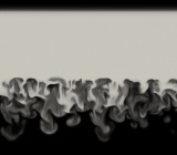
Gravitational instabilities developing at the base of volcanic clouds
Gravitational instabilities can increase the fall velocity of fine volcanic ash. The combination of field, experimental and numerical investigations is used to advance the characterisation of gravitational instabilities and their role in the deposition of volcanic ash.

Aeolian remobilisation of volcanic ash
Volcanic eruptions can generate large volumes of ash that can be remobilised through aeolian processes even millennia after initial deposition. We advance on the understanding of transport and deposition mechanisms through field and experimental analysis.

Multi-hazard, vulnerability and risk assessment at multiple scales and in various volcanic settings
Volcanoes can generate different phenomena that interact at different spatial and temporal scales. On the other hand, the exposed communities present different dimensions of vulnerability. As a consequence risk associated with volcanic eruptions is rather complex and dynamic. In the Physical Volcanology and Geological Risk Group, we work with various numerical tools to better understand the interaction between different volcanic hazards and different dimensions of vulnerability to achieve multi-risk analysis in various volcanic settings.

Forensic analysis and impact assessment of volcanic eruptions
Unfolding disasters is key to understand the chain of events and find ways to improve risk assessment and risk reduction. Therefore we carry out impact assessments, during or after events, in order to better understand the cascading impacts affecting exposed communities.
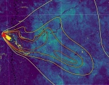
Remote sensing of volcanic impacts
How can remote sensing help better constrain and forecast the impacts from eruptions? We investigate impacts from eruptions at multiple scales using a range of sensors (e.g., multi-spectral, Lidar, SAR) and computing techniques (e.g., interpretable machine learning, structure-from-motion, big EO data) to develop new methodologies to complement and generalise field observations and laboratory analyses.