Projects

Structural mapping in volcanic areas
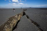
A part of our research is to understand how magma propagates through fracture zones at volcanoes and at divergent plate boundaries, such as on Kilauea volcano and in Iceland. Field work and structural mapping using a fixed-wing drone is a key component of our research and provide us large-scale high-resolution data to further develop models and sharpen our interpretations.
Multidecade ground deformation analysis at the Koa's fault system, Hawaii.
In this project we want to understand how fractures are contributing to the transport of magma and relates to the giant flank instability of the Kilauea volcano. We will analyse several decades of ground deformation and intrusion episodes in the Koa'e fault system and surroundings rift zones. We will use air photo correlation technique, structural field data, drone mapping and radar satellite interferometry to quantify the ground deformation from the 1950's to now.

Volcano tectonic processes in the laboratory
Volcanoes and volcanic areas are highly fractured zones and magma usually follows such fractured pathway to propagate and to reach the Earth's surface. We are using analogue experiments (sand box) and 3D topographic analysis to study how fluids propagate through fractured media under different boundary conditions. The goal is to identify the key parameters influencing the magma propagation direction and locations of future eruptions.