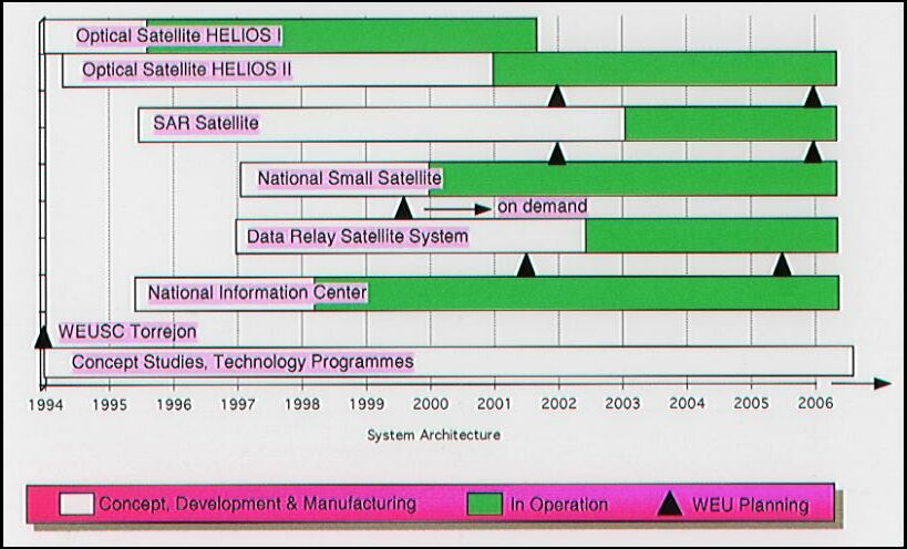
[Précédent]

General Introduction


1. Outer Space Technology Transfer: The Present Dilemma

      The right of any State to develop outer space technologies, be they launching capabilities, orbiting satellites, planetary probes, or ground-based equipment, is, in principle, unquestionable. In practice, however, problems arise when technology development approaches the very fine line between civil and military application, largely because most the technologies can be used for dual military and civil purposes. This dichotomy has raised a series of political, military, and other concerns which affect the transfer of outer space technologies in different ways, and particularly between established and emerging space-competent States. Accordingly, for many years several States have sought ways and means to curb the transfer of specific dual-use outer space technologies, particularly launcher technology, while still allowing some transfer of these technologies for civil use.

      However, controlling outer space technologies has never been an easy task. It has become increasing complex, not least because of the fundamental changes in international relations which have and continue to occur in the 1990s. Indeed, the nature and potential use of outer space and related technologies are such that, collectively or individually, States are often faced with the dilemma of having to choose between what could be an illegal transfer and permissive; between what could be a genuine civil use application at a certain point in time--but could be used for military purposes in another--and applications which are overtly or implicitly military in character. For example, the development of space weapons for offensive uses can be seen as a threat to international security and peace, despite the fact that they may, in actual fact, be components of defensive or deterrent strategies. Similarly, while the development of space launcher capability is not perceived as such a threat, access to this technology--because it could contribute to the acquisition of ballistic missiles--is often considered as detrimental to regional and/or global stability.

      A further factor is the changing collective perception of what constitutes military space. For example, the development of military-grade satellite technologies is often perceived as the acquisition of military technologies because, inter alia, military-grade satellite technologies have been traditionally used by some States to support their military doctrines. At present, international market access to military-grade satellite data is becoming more common and new civil and security-related applications emerging. Joint manufacturing ventures are also on the increase since they are now considered politically attainable, militarily desirable, and economically viable. Moreover, military outer space activities--whether space-based or not--are also used within the framework of United Nations Peace Operations (UNPOs), or as part of the security strategies of regional military alliances. Thus, the question of which specific aspects of outer space technology transfer could constitute a threat to international security acquires greater relevance. To answer this and related questions, it is necessary to consider complex fundamental issues, evaluate the political, military, technological, and economic ramifications of this matter, and assess the purposes and situations for which the transfer of outer space technologies are intended.

      Nevertheless, the development of outer space technologies continues in a quagmire of conflicting interests and technology transfer control rationales. First, there are political-military considerations where a State's decision to develop military outer space or related applications can be assessed not only as a function of perceived levels of threat to its security, but also as a need to respond to or leap ahead of potential technological innovations. Second, are the fundamental conceptual differences in appreciation among States of the right to possess different weapons and weapons systems for defensive or offensive purposes. Has a State which possesses military space technologies the right to restrain another from obtaining such capabilities? This is not a question limited to the dual-use issue. It has been at the heart of the haves/have nots debate in all the non-proliferation talks (nuclear, chemical, and biological issues and, to some extent, certain conventional weapons as well) for decades. Third, there are the economic implications, whose impact is perhaps the least well-known and debated of all. These economic implications include reluctance on the part of some States and/or organizations to promote increased competition in outer space manufacture. Concomitantly, the very competitive space industry exercises a measure of control on technology transfers via its industrial secrecy policies and market advantage strategies.

      In the midst of these and other interests the transfer of dual-use outer space technologies is caught between selective control regimes on the one hand and the absence of a universal agreement--of mutual interest--on the other. Dual-use technology transfers do not take place in a vacuum. Presently, they are affected by the aftermath of the end of the Cold War and the break-up of the Soviet Union, and the search for a new world order. Additionally, since major nuclear and chemical disarmament efforts are underway, non-proliferation will receive increased attention in future security debates--notably with respect to the strengthening of the Biological and Toxin Weapons Convention, new nuclear- and delivery systems-related (e.g., missiles and other rockets) agreements. The new era has required a reassessment of national priorities related to international security which affects the way global and regional geopolitical policies are conceived. Such a reassessment has led to a greater interest in civil-related issues, an approach which is more amenable to cope with development and environmental problems.

      While this new political direction may eventually stimulate a constructive turn in international relations, there is still an unanswered question: how can international security and peace in both the short and the long term be ensured? Central to this concern is the transfer of dual-use outer space technologies in general, and of delivery-vehicles in particular. For the time being, discussions on dual-use outer space technologies lack creativity; political will to promote diplomatic initiatives is also lacking. This situation does not necessarily further international security, nor does it foster co-operation in the civil use of dual-use outer space applications.


2. Thesis Rationale and Hypothesis

      It is in the specific context of the impact on international security caused by the transfer of dual-use outer space technologies that the rationale of the present thesis is argued. Currently, the relationship between the suppliers and the recipients of these technologies is based on selective control regimes which, in many instances, give rise to conflicting political situations. In the main, control regimes have been established to curb the development of ballistic missiles, military reconnaissance satellites, and other weapons and weapon systems. The argument could also be made, however, that economic considerations have also stimulated these control regimes. Polemics aside, the problems caused by these regimes are such that there is an urgent need to rethink their mode of implementation, added to which is the fact that control regimes have also hindered, both directly and indirectly, the development of certain civil-oriented space programmes.

      The hypothesis of this document is that the interests of both suppliers and recipients in the transfer of dual-use outer space technologies can best be served not through selective control regimes but through joint co-operative measures, because it is the most efficient way to control civil-use of outer space technologies, while at the same time ensuring their transfers. In order to prove this hypothesis, this document will therefore:

      appraise the specific, progressive steps required to achieve co-operation between suppliers and recipients of space technologies;

      assess the measures that would offer more transparency in technology transfer and thus lead to greater predictability of the end-use; and

      examine measures which could build-up confidence and security among States in so far as outer space technologies are concerned.

      In developing this rationale, this thesis does not undertake a detailed analysis of all outer space and related technology transfers, since it would be a tedious exercise which falls outside the scope of this paper's main objective. Rather, the discussion is limited to an appraisal of the relationship between technology-supplier States--i.e., those which reached competence in outer space activities between the 1950s and the 1970s--and potential recipient States--which are currently developing their first generation of indigenous space launchers, satellites, and/or ground stations. The debate in this document starts in the dawn of the space age and ends in the year 2000.


3. Methodology and Proposed Solutions

      It is clear that the objectives set forth above are not easy to reach. After all, the dual-use debate is not new and its complexities are also quite well known. It is therefore necessary to first clarify what outer space technologies actually are and what their dual use may entail. Understanding the technical intricacies is essential: for instance, are space launchers ballistic missiles? Unfortunately, the importance of the answer to this question is not always appreciated, for in it lies some of the fundamental reasons for controlling access to rocket technologies. Equally necessary is a survey as to which countries are most likely to export or import outer space technologies. Such an exercise would also be valuable in identifying countries which have assigned their outer space technologies to the military sector, since they are often the strongest proponents of control regimes related to technology transfer.

      In view of the need to evaluate and clarify the political and strategic implications of access to outer space technologies on international security, this thesis highlights the consequences that the dual use of outer space technologies can have on (a) the spread of weapons technologies and (b) the military use of space assets. More specifically, it appraises and clarifies some of the ramifications which are often discussed in the context of the non-proliferation debate. It also pays particular attention to launching vehicles capable of carrying nuclear or other payloads of mass destruction and the space component of such issues as Earth-orbit satellites versus space probes. Reconnaissance satellites are especially pertinent since their role in the next century has yet to be fully assessed and appreciated.

      At the same time, the focus of this thesis is an examination of several existing and future technology transfer control regimes, although the detail is narrowed to more space-related relevant instruments and arrangements. First, it is important to learn more about technology transfer issues and the role of national legislation. For example, central to the control regime debate is the discussion on the evolution, or lack, of national legislation covering dual-use outer space technologies, as well as a discussion on their orientation and scope. Which countries have developed or are developing legislative measures in this area? Are legislation on control regimes legally sound and implementable in practice, and to what extent? Second, at a time of fundamental change in the nature and order of international relations, the wisdom of ad hoc control regimes must not escape scrutiny. Although experts are very much aware of these problems, the future of control regimes remains uncertain, so what are their potential implications for international security? Hence, a reassessment of the problems surrounding existing control regimes must be made - both in terms of their foreseeable improvement and/or a possible new universal multilateral agreement, and within the context of an uncontrolled regime.

      This further argues the need for new international mechanisms to safeguard the transfer of dual-use outer space technologies, while not fuelling proliferation opportunities for weapon systems. This argument is not just ideological thinking. It could constitute the basis of a policy that could be implemented if certain specific initiatives are taken. To build confidence between suppliers and recipients of outer space technologies, adhesion to bilateral agreements on space technologies and activities, arms limitation agreements on weapons of mass destruction, and other measures would offer increased transparency in the development of outer space activities as well as higher levels of predictability. Of course, the roles of both suppliers and recipient States in unilateral, reciprocal measures would have to be carefully evaluated. Concession issues would need to be given the highest priority in order to improve predictability and the creation of crisis management mechanisms.

      Multilaterally, there should also be agreement to establish a dialogue mechanism between suppliers and recipients, to enable mutual political objectives to be complemented by compliance and enforcement procedures. Central to the debate would be a discussion of fundamental, practical questions. For example: is it appropriate to undertake multilateral negotiations? If so, in what form and at what type of forum should they take place? Whether a World Space Organization (WSO) could solve outer space technology transfer problems also finds legitimacy in this context.

      However, scrutinizing ways of creating new relationships between suppliers and recipients in the transfer of dual-use outer-space technologies can easily be a zero-sum-game endeavour. The challenge is to instigate impartial and innovative thinking. Moves favouring co-operation simply for the sake of ensuring the transfer of dual-use technologies are not the answer here! Moreover, while international organizations have their role, they are not a panacea, as the comprehensive test ban treaty discussions have shown. The costly, complex exercise that led to the Chemical Weapons Convention (CWC) should not be taken as a precedent.

      In conclusion, the question of whether there should be a better restructuring of outer space technology transfer would now appear to be irrelevant without a better understanding of the present relationship among States on the vital outer space sector of the security debate. The quest for improved relationships in respect of technology transfer and dual use must first start with an assessment of the political, military, technical, and economic implications of outer space technologies. Any such assessment must therefore consider the relevance that access to these technologies has for different geopolitical situations. Only by co-operation can the supplier/recipient relationship be established in a sound, durable manner. However, any such co-operation must be reinforced by agreements to ensure transparency and predictability on issues which directly affect the security and development of individual States or groups of States.

      The right of any State to develop outer space technologies is, in principle, unquestionable. In practice, problems arise when technology development approaches the very fine line between civil and military application, largely because most the technologies can be used for dual military and civil purposes. This dichotomy has raised a series of political, military, and other concerns which affect the transfer of outer space technologies, and particularly between established and emerging space-competent States. Accordingly, several States have sought means to curb the transfer of specific dual-use outer space technologies, particularly launcher technology, while allowing some transfer of these technologies for civil use. This document argues that the interests of both suppliers and recipients States can best be served not through selective control regimes but through joint co-operative measures, because it is the most efficient way to control civil-use of outer space technologies, while at the same time ensuring their transfers.


Part I
Dual-Use Outer Space Technologies: The Terminology

      The meaning and scope of certain terms, many of which are used interchangeably to describe specific objects and behaviours in the transfer of dual-use technologies can confuse the experienced reader just as much as the novice. Mutual understanding of these terms is therefore crucial in understanding the issues related to this paper. The purpose of Part I is therefore to define the terminology to be used below. Among the many terms with multiple meanings are technology transfer, dual use, outer space (as distinct from air space), ballistic missile, delivery vehicle, space launcher and sounding rocket.

      There is also a need to explore the latest developments in capabilities and the identification of different categories of competence. The question of who does what in outer space will accordingly be addressed at some length. A description of what are called Established Space-Competent (EtSC) States is also appropriate, not only because of these countries' capability to manufacture space equipment, but also because of their capacity to supply outer space technology to the international market. 1 

      However, it is not enough to describe the EtSC States alone. Hence, the Emerging Space-Competent (EmSC) States, known as technology-recipient States, are also identified. The relationships, routes, and progress of EmSC States in their quest for outer space capability do not necessarily resemble those of EtSC States, although the past, present, and prospective growth of their national space programmes are unquestionably interwoven. In many instances such progress is an essential factor in the technology transfer debate. This is particularly true of the actual and potential military capabilities of EmSC States.


1. Definition of Terms

      The transfer of dual-use outer space technology is such a vast subject that an entire thesis could be devoted to its terminology alone. However, for obvious reasons, the present paper will focus on the meaning of technology transfer and dual use, describe how these terms are applied in the context of outer space, and examine how dual use can be effectively identified among different applications.


A. Technology Transfer

      The term "technology transfer" may be used in a variety of circumstances because there is little agreement among experts on its actual meaning. While some experts contend that a clear-cut meaning can be identified, at least one other school of thought argues that the term "technology transfer" is meaningless. There may be some justification for the latter argument since technology transfer could be used, in a general sense, to imply the movement of technology from a supplier to a recipient. This may seem to be an oversimplification, but it is actually quite a complex statement. First, those involved in transfer can be individuals, companies, States, or any other type of enterprise. This complicates the issue in that "technology transfer" defines neither the supplier nor the recipient, thus creating an "identity" problem when the issue of legal responsibility has to be addressed.

      A further complication is the fact that the word "technology" is itself vague. Is it an abstract concept or can it be identified as a tangible asset? The answer is not necessarily readily evident. A "grey area" between the two concepts would provide a greater degree of flexibility in definition according to the circumstances at stake. For instance, a transfer could involve complete or selective movement of know-how regarding a given system, manufacturing equipment, finished product, or service (see Diagram I.1.A). As the Diagram illustrates, technology transfer can also affect a prospective recipient's increased capability to become autonomous and, therefore, also become, in its turn, a supplier in the future. However, it is also important to note that mere movement of goods or services may not necessarily enable the recipient to access the technology. For instance, a recipient may engage in technology transfer but unable to absorb it because of insufficient scientific, human, financial, or other fundamental technological resources. Thus, "technology transfer" would not apply in such a case--although it could be argued that an attempt to transfer technology may have been made. Even if there is no difficulty in accepting this assumption, there will still be a problem in regard to ability to identify and distinguish the movement of technology and assets from non-transfer-related events.


Diagram I.1.A: Definition of Technology Transfer

      To reach a clear definition of technology transfer, three other issues must be addressed: (1) the conditions in which it can occur; (2) the ability the supplier/recipient to provide/absorb transferred assets so as to permit their coherent use; and (3) the fundamental objectives behind the decision the supplier/recipient to transfer/acquire the technology. In the first and second instances, it is difficult to estimate the transfer conditions because the flow of technology between a supplier and a recipient may not be easily identifiable. For example, in a joint-venture, the R&D of a given system may depend not only on a supplier's input but also--and to varying degrees--on that of a potential recipient. In such an example, the concept of sharing technology R&D may also be added to the definition as part and parcel of the technology transfer process.

      Additionally, input should not be characterized only in such terms of abstract participation as the provision of knowledge, but also in terms of human, financial, and other investment resources - which adds to the difficulty of identifying technology transfers. In the third instance, the decision to acquire technology--as distinct to undertaking indigenous R&D--is often closely linked to a need to decrease programme costs and development time, while at the same time widening the scope of potential applications. 2 

      Therefore, it seems that, to be pertinent, a working definition of "technology transfer" for the purpose of this paper has to take three factors into consideration - namely:

(a) the existence of asset movement, including knowledge and services, between two or more protagonists;

(b) the possibility that a recipient may employ the transferred assets either to produce finished products or to provide services without the assistance of the original supplier; and

(c) the ability of a recipient to have access to a given technology in a manner that would save time, financial investment, and other resources.

      In conclusion, for the purpose of the present discussion, the term "technology transfer" is neither meaningless nor vague. On the contrary, it carries a strategic vision and responds to specific criteria.


B. Outer Space and Dual-Use Technologies

      In the light of the above definition, the transfer of outer space technologies would naturally refer to the movement of outer space assets, applications, and services between suppliers and recipients. However, outer space is an environment and it is not particularly obvious, a priori, how the outer space environment fundamentally relates to technology transfer. There is no precise, universally agreed, legal, technical, or political definition of the boundaries separating outer space from air space or from deep space, nor is there any agreement in diplomatic and/or scientific quarters of the term "outer space" itself. 3  One of the major obstacles in defining the boundary between air space and outer space is the difficulty in obtaining agreement on the quantifiable physical parameters dividing the two environments. Moreover, this boundary is not necessarily stable and may, at some point in time, be affected by atmospheric changes and/or physical phenomena. However, for the purpose of the present discussion, a working definition of outer space could be as follows: 4 

[o]uter space is all of the space surrounding the Earth where objects can move in at least one full orbit around the Earth without artificial propulsion systems according to the laws of celestial mechanics, without being prevented from doing so by the frictional resistance of the Earth's atmosphere. It extends from an altitude above the earth of approximately 100 km upwards.

      Under this working definition, any technologies which contribute directly to applications in such an environment could be considered as outer space technologies: e.g., rocket boosters, satellites and their components, and Earth-based control and tracking systems. Equally, other technologies contributing to these and other outer space applications in a less direct manner could be considered as "related" outer space technologies -- for instance, the technologies of systems and sub-systems which could be used instead of the traditional means of manufacturing and operating space devices. In consequence, the following questions may then be raised: (1) what are dual-use outer space technologies, and (2) how can they be distinguished from single-use technologies? Are operational interactions and technical similarities the only criteria to differentiate dual- from single-use technologies? Or are there other more conceptual and less technical reasons?

      The term dual is used in its generic sense to denote the mathematical number "two". When used in relation to an operative verb such as use, "dual" means more than one employment, nature, or characteristic of a given object or method, or any other word it qualifies. More specifically, in the context of outer space technologies, dual use can be defined as being a usage which has both civil and military employment, whether proven or potential. In a more general sense, dual use also embraces weapon technologies and their systems and sub-systems, in any of their different basing modes: ground-based--fixed or mobile, ship-mounted, air-mounted, and space-based. However, while there are a great variety of weapon-specific systems that could be associated with outer space, it is the non-weapon technology that could be employed for military purposes which is the most difficult to define.

      For example, in rocketry, the line differentiating booster technologies from ballistic missiles is rather fine. It is a core issue in international security debates. Indeed, it is often thought that the possession of the former is a passport to obtaining the latter. However, rocketry technology is only one component of the dual-use debate. It is therefore important to understand the dual-use nature of both artificial satellites 5  and rocket/satellite Earth-based tracking technologies. Here too, the line between civil and military technologies is difficult to draw. One may therefore question how these technologies can be identified and also, equally importantly, how they have been employed in terms of dual use. The discussion which follows is an attempt to illuminate these issues.


C. Space Booster or Ballistic Missile Technologies?

      Different launch vehicles may provide distinct, diverse applications and three major categories of carrier rockets using outer space technologies can be identified: (a) sounding rockets, (b) space launchers, and (c) ballistic missiles. While the first two rockets are essential to the space boosters (or space launching vehicles) used for the exploration of outer space, the BM is propelled into outer space with the intent to use that environment only as a pathway to its final destination back into the Earth's atmosphere--with, however, the exception of an attack on satellites such as Anti-Satellite (ASAT) weapons.

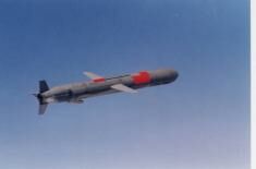
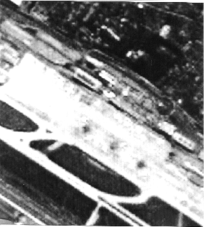
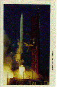
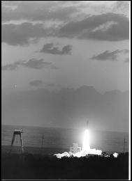
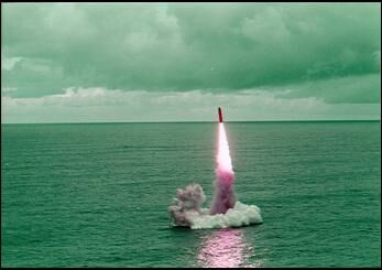
      Sounding rockets are usually employed for scientific studies and provide the capability to conduct endo-atmospheric and, more importantly, exo-atmospheric experiments 6 --the latter providing limited access (a few minutes) to microgravity. 7  These rockets usually have a range less than 1000 km and most have a single solid fuelled-propelled body (see examples in Photos I.1.1 and I.1.2). In most cases, their trajectories are designed in such a way that, via its parachute, the payload returns to the vicinity of the launch pad, thus allowing the payload-bay and its scientific equipment to be recuperated and perhaps reused for other missions.


Photo I.1.1: Example of a Solid-Fuel Graphite Fibre Rocket Motor

Courtesy the US DoD


Photo I.1.2: Example of a Solid-Fuel Motor Test Fire

Courtesy the US DoD

      As may be seen from Photo I.1.3, sounding rockets are intended to carry experimental scientific experiment equipment in their payload-bay or to conduct experiments themselves. Different signals from experiments provide Earth stations with data derived from devices in the payload-bay, such as visual and parametric observation of experiments conducted during the endo-atmospheric and/or exo-atmospheric phases of the flight. This allows scientists in Earth-based stations to have real-time access to the experiments and the possibility of transmitting experiment-related telecommand signals 8  to the vehicle's experimental scientific equipment.


Photo I.1.3: Example of Sounding Rocket Payload Bay

Courtesy of MBB/ERNO Orbital Systems & Launcher Division

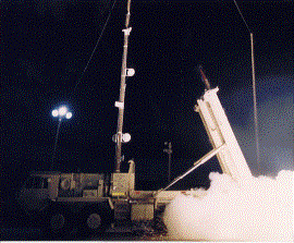
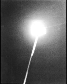
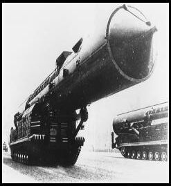
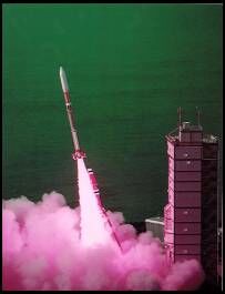
      Space launchers are, however, technologically more complex and financially more demanding than sounding rockets. Their technical characteristics and mission functions are also different, because space launchers are exo-atmospheric rockets which can be used to reach low Earth orbits (approximately 150-500 km), high altitudes such as geostationary 9  orbit, and even deep space (over 40,000 km). Thus, there are different types of space launchers for different Earth and transfer orbits. Consequently, launchers designed to reach geostationary and high transfer orbits are more complex to construct than those for low orbits because--assuming the rockets carry equal payloads-- considerably higher thrust power is required. Space lunchers can have different body structures and propulsion fuels: some have a single body while others have three to four stages as well as strap-on boosters. 10  Usually, strap-on boosters are propelled by solid fuel, while the main body of the space launcher uses a combination of solid- and liquid-propelled motors. 11  As shown in Photo I.1.4, liquid-fuel motors are structurally more complex and more cumbersome to operate than solid devices. Only a few States are able to manufacture cryogenic propellant, a special high-performance liquid fuel for liquid boosters. 12 


Photo I.1.4: Example of Liquid-Fuel Motor (Japanese H-2 LE-7 engine)

Courtesy of NASDA

      Mission space launchers--which are sometimes called expandable launchers--are rockets which place satellites and manned vehicles into Earth orbits or launch probes into deep space. They have a greater payload capability than sounding rockets, although their satellites do not always contain scientific study instruments. The difference in mission purpose also reflects a difference in the form and size of the rocket's payload-bay structure (see Photos I.1.5 and I.1.6). In addition, the type of trajectory of space launchers also differ from those of sounding rockets, with the additional particularity that space launchers are not usually intended to return to the Earth: they either burn-up when they re-enter the Earth's atmosphere or remain in outer space as space debris. There are, however, vehicles that carry astronauts into outer space and are designed to have their manned capsulae re-enter the Earth's atmosphere and then be parachuted into the sea or onto the ground as well as the capability to perform regular aircraft-like landings.


Photo I.1.5: Example of Space Launcher Payload-bay-I (Preparation before closing the fairing)

Courtesy of Arianespace


Photo I.1.6: Example of Space Launcher Payload-bay-II (Satellite composite mating on to the launcher)

Courtesy of Arianespace

      Manufacturing technologies for sounding rockets and space launchers are very similar to those used in developing delivery vehicles such as ballistic missiles (BMs), although the use of BMs differs in principle and purpose. For example, sounding rockets (apart from air-launched ones) and space launchers perform a vertical or near vertical launch and are propelled into outer space for a given mission. Some of them execute a V-shape trajectory to re-enter the atmosphere. BMs, on the other hand, are propelled into outer space by a booster rocket (usually also via a vertical or near-vertical launch), after which they make a free-fall descent towards a given target on the ground or at sea, performing a ballistic trajectory to deliver a military payload (see Diagram I.1.B). In other cases, a single missile may have a varying number of smaller vehicles (re-entry vehicles) operating the re-entry of the atmosphere and completing the ballistic trajectory described above.


Diagram I.1.B: Standard Rocket Launch Flight Trajectories, Ranges, & Basing-Modes

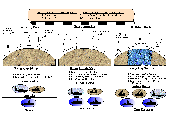
      BMs can also use space booster technologies for specific military needs - for example, the re-entry of rockets or their nosecones and control during the re-entry part of the flight or special computers and software for guidance and target-locking purposes. In addition, the structural form of BM payload-bays may be only slightly different from that of the space boosters. Furthermore, their payload-bays are usually located at the upper part of the rocket, although they are designed to carry munition payloads for hit-and-kill (kinetic-encounter), nearby-explosion purposes, and/or radiation effect (see Diagram I.1.C). Depending on the size of the rocket and its type of fuel propulsion, the payload may vary from conventional to mass destruction munitions (e.g., nuclear, chemical, or biological/toxin agents). An example of a BM payload-bay with re-entry vehicles warheads is shown in Photo I.1.7.


Diagram I.1.C: Potential Ballistic Missile Technology Applications

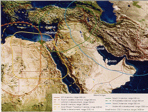
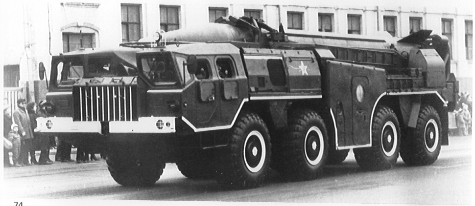
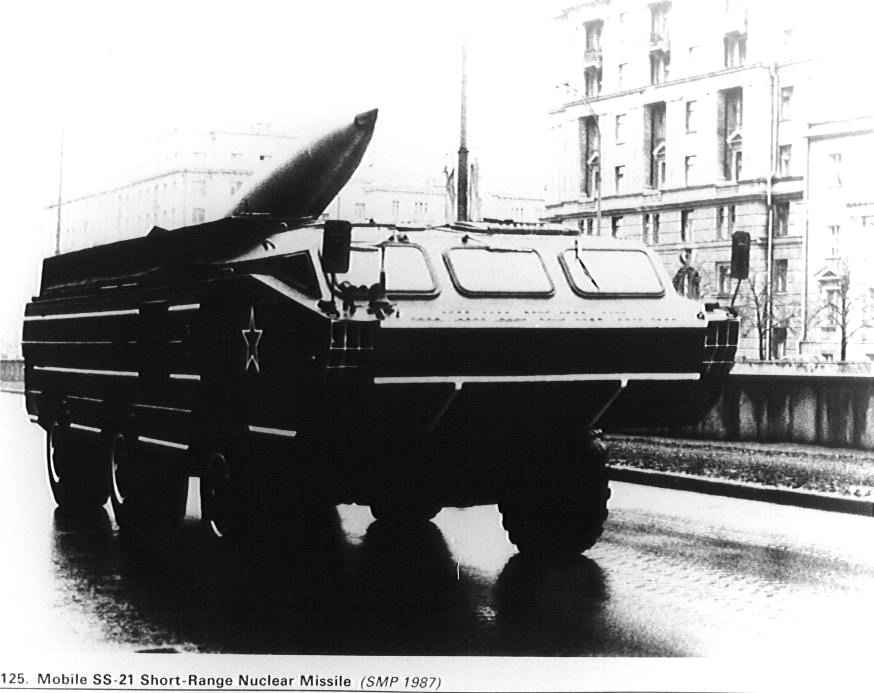
      BMs exist in different versions and basing modes, including fixed ground-based, road/railway mobile, submarine- and air-launched vehicles, some of which have a range of up to 16,000 km, with apogees of up to 12,000 km. 13  In addition, BMs can be either solid or liquid-propelled, the latter being more common in long-range intercontinental missiles. Thus, the components of such rockets are undeniably dual-use in character and the acquisition of space-booster manufacturing capability provides the recipient country or enterprise with the basic technology for developing BMs.

      Photo I.1.7: Example of a Ballistic Missile Payload-bay [image non disponible]

Courtesy of the US DoD

      Configuration of a payload nose cone and three warheads: Multiple Independent Re-entry Vehicles (MIRV) shown with protective nose cone removed.

      The reverse is also true, that is to say that access to BM manufacturing capability provides the recipient country or enterprise with the basic technology for developing space launchers. Moreover, the infrastructure created for outer space applications may also have other military ramifications in the rocketry field. This is especially the case with regard to launch sites, because space booster launching sites can also be used as missile bases - although experience has so far shown that the reverse is often the case when missile or air force bases have been used as launching sites.


D. The Nature of Dual-Use Satellite Technologies

      In general, there are three major categories of artificial orbiting satellites: scientific, application, and test (experimental). Scientific satellites are space-orbiting devices for scientific experiments, as discussed above in connection with sounding rockets, and they carry an array of different measuring devices. Application satellites are designed for meteorological operations, remote-sensing, communications, geodetic measurements, and various other uses in outer space. Test satellites are to confirm technologies for future satellites or for space launchers.

      Similarly to space vehicle technologies, satellite technologies play an important civilian role in the development and life of modern society, providing both real-time services and a platform on which various scientific field experiments can be made. However, the nature of satellites' working environment and the variety of operations it offers also makes satellites attractive for military purposes, not least because while air space is subject to States' national laws and sovereignty, satellites can move around in outer space without any such legal constraints. In addition, they can move around the Earth in different orbital planes (e.g., low Earth orbit, circular semi-synchronous orbit, elliptic semi-synchronous orbit, and geo-synchronous orbit), 14  thus allowing some degree of flexibility in preparing local, regional, and over-the-horizon military contingency plans or campaigns.

      Moreover, satellites are also able to cover large areas and provide data repeatedly. Depending on the technology involved, the data may be for short-term tactical use or long-term analysis of military strategy. Having now been used both directly and indirectly during conflict and in peace, the value of military satellite technology is no longer in doubt. 15 

      Complete satellite systems have been developed as dedicated military devices and an array of satellites for strategic and tactical reconnaissance as well as intelligence data collection now support nuclear and conventional deterrence postures as well as actual military operations. Existing dedicated military technology includes satellites which can emit and receive communications signals that are owned or operated by the armed forces of different countries. Such satellites provide "Communications, Command, Control and Intelligence" (C3I) capability supporting military combat operations. 16  Similarly, meteorological satellites can supply real-time global and local visibility through the visible light and infra-red parts of the image spectrum.

      Data provided by geodetic satellites, for instance, were originally designed to determine the exact size and shape of the Earth's surface and its gravitational field in order to produce highly-detailed maps showing the precise location of cities, towns and villages. Today, geodetic satellites are also used to improve the accuracy of intercontinental ballistic or cruise missiles. 17 

      In addition, navigation satellite technology, which can provide the position of a receiver-point on Earth, is also used to make atmospheric measurements to determine optimal missile trajectories (e.g., water vapour content and wind velocity along a missile's possible trajectory). Navigation satellite data are also used for troop-position determination in and around battlefields and elsewhere. Ocean surveillance satellites are used to locate surface ships and to determine their nature and direction. Such satellites often carry infra-red and microwave radiation detection sensors which can detect submarine missile launchings. There are also specially conceived satellites which carry infra-red devices to monitor the heat of rocket plume to detect BM launches and calculate their range of operation. Thus, early-warning satellites can be used to detect a potential BM first strike. In addition to these detection and identification missions, this technology could also be used , if necessary, to provide missile flight data on weather and other atmospheric conditions and guidance in order to optimize the performance of weapons and weapon systems in retaliatory missions.

      Other reconnaissance satellites of a more general nature are designed for (a) area surveillance and close-look missions; (b) monitoring military radio communications; (c) detecting/jamming missile telemetric data; 18  and (d) monitoring/verifying arms control and disarmament agreements. For example, reconnaissance satellites have been used to detect and/or identify Inter-Continental Ballistic Missile (ICBM) silo bases, as well as other ground-based mobile missiles and their systems. This type of mission includes BMs manufacturing and storage facilities, in addition to the monitoring of naval bases and docked nuclear and other submarines. Electronic intelligence satellites, on the other hand, can hinder an adversary's incoming missile or satellite telemetric signals by jamming.

      However, data provided by certain civil satellites--such as non-dedicated military systems or platforms--have also been used for military purposes, 19  thanks largely to the availability of military-grade data on the civilian market. For instance, the availability of Earth observation data of 10-m resolution on the civil market responds to an ever-increeasing need for highly accurate map-making equipment in urban and environmental planning, but this technology could also provide the necessary equipment to increase the accuracy of weapons and weapon systems. 20  The use of civil satellite data for military purposes is not limited to such examples . It can also be linked, as dedicated military satellites are, to the actual support of real-time battlefield and other operations.

      It is such factors as these, coupled with the continuous technological increase in civil satellites and the changing environment of international security, that cause some experts to question the very definition of the term "dual use" in regard to satellites. They argue that the term has mostly been considered from what is frequently called the traditional unilateral perspective of the military and civil use of outer space technologies. 21  To redefine the term "dual use", a proposal has been made to adopt a different approach referred to as simultaneous multiple use of satellite technologies. This argument is that, in the not so distant future, it will become common (as distinct from ad hoc) practice for civil satellites to perform military missions and military satellites to perform civil functions. Hence dual use will become multiple use. Such a change in terminology, if it were to be widely accepted, would revolutionize the way satellite applications in particular, and space technologies in general, are perceived and employed.


E. Rocket/Satellite Earth-Based Tracking Technologies

      The dual-use nature of space booster and satellite technologies is also a factor in the development of their Earth-based control systems. 22  Space agencies and institutions worldwide possess emission/reception antennae, radars, optical devices and other technical equipment that are used for the tracking and acquisition of launch vehicle and spacecraft telemetry. These systems can receive telemetry from the vehicles and send commands to the spacecraft (see Photo I.1.8), notably to acquire spacecraft velocity and position with respect to the Earth and to provide real-time transmissions of such data to space flight operations facilities during and after the active life of satellites. In addition, these types of antennae are also used to study non-artificial space debris and meteorites.


Photo I.1.8: Example of Telemetry, Tracking, and Command. Antenna for Deep Space Probes

Courtesy of the Japanese Institute of Space and Astronautical Sciences

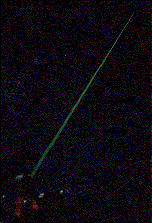
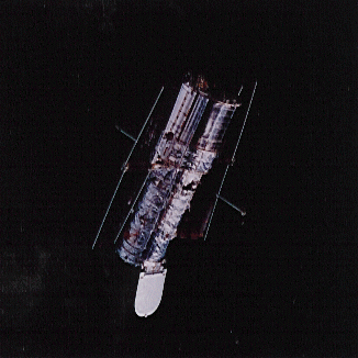
      Telescopes and radar-interferometry and state-of-the-art technology such as laser systems can also provide the data identifying rocket trajectories and satellite orbits. 23  Figure I.1.1 illustrates an example of active imaging whereby lasers are used to illuminate an object in outer space as an aid to passive equipment such as a telescope. In contrast, Figure I.1.3 shows the kind of image that can be obtained from optical systems on the ground namely, the Hubble Space Telescope in outer space where the satellite's main body and solar panels are clearly identifiable (compare it with Photo I.1.9).


Figure I.1.1: Laser and Telescope Tracking

Courtesy of Philips Laboratory, Albuquerque, USA

      However, given the appropriate specific technology, Telemetry, Telecommand & Tracking (TT&T) antennae can also be used for military purposes. For example, fixed ground-based and ship-mounted radars employed to track space debris are also utilized as dedicated or non-dedicated military systems to provide (a) early-warning of ballistic missiles and (b) surveillance of other objects crossing the radar's range. Indeed, in addition to providing early-warning of BM launches, military systems are also designed to track satellites and space debris, as well as BMs re-entry into the Earth's atmosphere. This capability enables objects and missiles to be distinguished in flight. Accordingly, dedicated military systems are used to maintain a database of objects in Earth orbit, the number and position of which are constantly changing.

      Fixed ground-based and ship-mounted antennae used for the TT&T of satellites are also employed for the reception of telemetric data of ballistic missile tests. Other less weapon-related employments of this kind of equipment include the use of an array of antennae for dedicated military communications purposes.

      Nevertheless, the acquisition of all or any of the above-mentioned technologies can be as time-consuming and costly as it is attractive, and the difficulties commensurate to the potential benefits envisaged. It is for these and other reasons that States which are active in outer space activities do not possess or indeed have access to every feasible type of application--a matter which is discussed in the following chapter.


Figure I.1.2: Hubble Telescope as seen from AMOS

Courtesy of Philips Laboratory, Albuquerque, USA

      
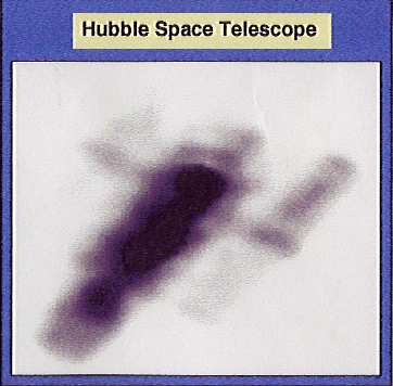
The Hubble Bug, as imaged by the Philips Lab at the Air Force Maui Optical Station at Mount Haleakala, Hawaii.


Photo I.1.9: Hubble Telescope as seen from the Space Shuttle Discovery (1997)

Courtesy of NASA

2. The Development of Outer Space and Related Capabilities

      Identifying actual, emerging, and potential outer-space competency among States is more difficult than it might seem. Moreover, any attempt to find precise, widely acceptable definitions of such terms as "Established Space-Competent State" and "Emerging Space-Competent State" would call for an in-depth analysis and comparison of several unequal parameters which are inappropriate to the present paper. 24  However, there are some parameters which, when considered individually or together, can identify some measure of outer-space competence. Therefore, for the purpose of the present discussion competence in manufacturing qualified outer space equipment 25  can be taken as a dividing line to distinguish the haves from the have nots in respect of three major infrastructure capabilities: the capability to design and manufacture (a) rocketry, (b) orbiting satellites or probes, and (c) launching and tracking site installations. In all of these areas, manufacturing infrastructure capabilities include the technologies used for launching and orbiting devices, and Tracking, Telemetry, and Control (TT&C) plus the maintenance of adequate services and a sustained commitment to the exploitation of these capabilities and services, and the training of personnel.

      It should be noted from the outset that only a few countries have so far demonstrated their outer-space competence. A non-exhaustive list of such EtSC States inevitably includes the USA, the former Soviet Union (now the Russian Federation), the European Space Agency (ESA) as an organization in its own right as well as most of its individual Member States, and Canada. However, a long, well-established reputation in the international commercial market should not be considered as sine qua non for inclusion EtSC State list, and therefore other countries which have more recently entered that market, such as Australia, China, and Japan, should also be added to such a list.

      States can be classified into four categories of access to outer space technologies with respect to the development and sophistication of their space programmes. Currently, as leaders in space competence, the USA and the Russian Federation belong to what could be defined as Category I. In Category II, we find States which manufacture outer space equipment without, however, having the same degree of outer-space activity as the Americans and the Russians. Without being exhaustive, China, Japan, and various European countries (individually or collectively within the framework of ESA) can be listed in this category.

      Then come the States in Category III. These are countries which are still acquiring basic, qualified outer space technologies, some with the aim of joining the ranks of EtSC States and indeed becoming suppliers of technologies and services before the end of the century. Argentina, Brazil, India, Israel, and Pakistan can be identified as belonging to Category III and, to a lesser extent, other States such as South Africa could also be included as discussed below. Category IV of outer space competence covers States, such as Indonesia and South Korea, which have announced their intention to initiate outer space activity sometime in the future. Also assignable to this Category States which have no intention of manufacturing systems or sub-systems, but wish to access derivative services.

      These four categories of outer-space competence should be regarded as working guides for a better understanding of the various issues at stake in the transfer of outer space technologies. To illustrate this point, the discussion which follows will focus on the evolution and present state of development of different outer space programmes and their dual-use civil/military character. In many instances, the relationship between the civil and military employment of the technologies is obscure. Thus, the discussion will illustrate why Category I and II EtSC States are presently technology supplier States and why and how EmSC States have become technology-recipient States.


A. Established Space-Competent States: Technology Supplier States


1. Reaching Outer Space

      The first country to put its research and development of outer space and related activities into actual practice was the former Soviet Union, by launching the first intercontinental ballistic vehicle in 1956. 26  Subsequently, the Soviets also put Sputnik-1 rocket 1 into orbit in 1957 and a vehicle carrying Lieutenant Yuri Gagarinon on 12 April 1961, making him the first man to travel in outer space. Not surprisingly, it is reported that Soviet space-launching vehicles were developed from ballistic missiles or ballistic missile programmes. 27  Table 1.1 lists some of the the Soviet-Russian BM missiles which are closely linked to space-launcher development, while Table I.1.2 summarizes some of the technical characteristics of major Soviet-Russian space launchers. A careful look at both these tables reveals a number of similarities between other missiles and space boosters.

      The Sputnik space booster which first orbited on 4 October 1957 is said to have been converted from the SS-6 Sapwood BM, which had itself been successfully test launched on 3 August of the same year. 28  Among such launchers still in operation in the mid to late 1990s was the Lance series (e.g., Molnya and Kosmos have largely derived from the SS-5), which is propelled with liquid-fuel motors and usually employed for low- to mid-altitude orbits. 29  The three-stage Tsyklon space launcher is another operational space launcher which is said to derive from the SS-9 and SS-18 families. 30  SS-9 BMs have been reported as being the booster for the FOBS (Fractional Orbital Bombardment System) which, in the event of hostilities, could deliver warheads against the United States on a south polar orbit. 31  There are few Soviet-built non-military-derived space launchers and in fact the only such vehicles that are still operational derive from the heavy-lift Proton rocket family. 32  Proton rockets, in particular the D-1-e version, were the cornerstone of Soviet geostationary launches and still are for the Russian Federation. In addition to the Proton, the Zenit and the Energiya may also have their origins in designs for civil rocketry. Their development, however, is believed to have received much support from the military. In the beginning, Zenit was intended to be both a satellite launcher and a strap-on booster for the Energiya system.


Photo I.2.1: SCUD-1B Missile (Soviet-Russian)

Courtesy of the US DoD

      The new relationship between Russia and the USA in strategic matters has stimulated the recycling of certain major missiles and their launching modes. For example, some decommissioned versions of BMs, or parts thereof, are being redesigned for use in sounding rocket campaigns or satellite launching. One initiative is the development of a mobile booster for low-mass launches using the Soviet SS-20 missile. 33  In addition, the US/Soviet START I and II agreements include provision for the use of ICBMs and SLBMs for civil launches. In this connection Russia has shown particular interest in using SS-18, SS-19, SS-24, and SS-25 ICBMs as heavy-lift vehicles. A modified SS-19 ICBM was reportedly tested for its commercial applications potential on 20 December 1991. 34  The first so-called "demonstration flight" of a converted rocket carrying a satellite was reportedly made on 23 March 1993. 35  More recently, a number of proposals have included the use of submarine-launched BMs as space boosters (e.g., SS-N-8 "Swafly" launched from a Delta-1 submarine, the SS-N-18 "Stingray" launched from the Delta-3 class submarine, and the SS-N-20 "Sturgeon" and SS-N-25 "Skiff" launched from the Delta-4 class submarine). 36 

      Another configuration, the "Volna" space launcher, was derived from the SS-N-18 missile and was intended to be commercialised in 1990s. 37  The "Shtil" rocket family (1, 2, and 3) derives from the SS-N-23 missile and was also intended to be commercially available as of 1995 38  By the mid-to-late 1990s, over 200 "Pioneer" rockets (SS-20) and close to 60 "Start" (SS-25) have reportedly been launched, some of them unsuccessfully. 39 

      In regard to air-launched missiles, the SS-24 "Scalpel" missile technology is said to be the basis of a new space launcher called "Space Clipper", which will be launched from a Russian An-124SC Ruslan aircraft. 40  Demonstration flights of some of these new space-launch vehicles - the SS-N-20 "Sturgeon" code-named Surf as a space launcher and the Space Clipper-- were reportedly expected during the course of 1994, 41  but the open literature has carried little about these programmes since the early 1990s.


Photo I.2.2: SS-21 Missile (Soviet-Russian)

Courtesy of the US DoD

      
Table I.2.1: Selected Ballistic Missile Technology Development by EtSC States: Level-I Countries
Country/Rocket N° of Stages Propulsion Range
(Km)
First in Service
USSR-Russia        
Ground-based        
SS-4 Sandal* 1 Liquid 540 1959
SS-5 Skean* 1 Liquid 1080 1961
SS-6 Sapwood*       1960
SS-9 Scarp*   Liquid 700 (miles) 1967
SS-18 Satan*   Liquid 11000 1974
SS-19 Stiletto*   Liquid 10000 1974
SS-20 Saber 2 Solid   1977
SS-24 Scalpel***   Solid 10000 1987
SS-25 Sickle**   Solid 10500 1985
Submarine-launched        
SS-N-6 Serb 2 Solid 810 1968
SS-N-8 Sawfly   Liquid 7800 1973
SS-N-18 Stingray   Liquid 6500 1978
SS-N-20 Sturgeon   Solid 8300 1983
SS-N-25 Skiff        
USA        
Ground-based        
Atlas D/E/F -.. -..   1959
Titan I/II 2 Liquid   1962
Minuteman I 3 Solid   1962
Minuteman II 3 Solid 12500 1966
Minuteman III 2 Solid 11000 1962
Submarine-launched        
Polaris A2/A3 2 Solid 810/1,350 1960-62/74
Poseidon C3 2 Solid 1350 1971
Trident I C4     7400 1979
Trident II D5 3 Solid > ; 4,000 nm 1990

      EtSC= Established Space-Competent States; ..= Data unavailable. *= Fixed system; **= Road mobile system; ***= Rail-mobile system.

Source: Data compiled by the author partially in light of information in Thomas B. Cochran, William M. Arkin, Robert S. Noris, and Milton M. Hoeing, US Nuclear Warhead Production Volume II, Nuclear Weapons Databook, National Resources Defense Council, Cambridge: Ballinger, 1987, pp. 17-19; Thomas B. Cochran, William M. Arkin, Robert S. Noris, and Jeffrey I. Sands, Soviet Nuclear Weapons, Volume IV, Nuclear Weapons Databook, National Resources Defense Council, New York: Harper & Row, Ballinger Division, 1989, pp. 2-19; Philips S. Clark, "Converting Soviet Missiles into Russian Space Launchers," Jane's Intelligence Review, September 1993, pp. 401-04; World Armaments and Disarmament SIPRI Yearbook 1972, SIPRI, Almqvist & Wiksell: Stockholm, 1972, pp. 4-5, 22; and others.


Photo I.2.3: SS-X-14 Missile (Soviet-Russian)

Courtesy of the US DoD


Photo I.2.4: SS-X-15 Missile (Soviet-Russian)

Courtesy of the US DoD

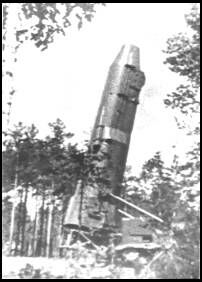
      Under the designation of "Shtil-3A" and launched from a pre-equipped AN-124 aircraft, an SS-N-23 missile-derived rocket is under development and expected to be commercialized by 1999 at the latest. 42  The creation of another air-launched vehicle is also underway. R&D is also moving on the "Rif-MA" space launcher, which uses the SS-N-20 missile as the basis for a rocket to be launched by the AN-225 aircraft.

      Another new launch vehicle, named "Prioboy", is the Prioboy-1 version. In contrast to the new submarine- and air-launched rockets referred to above, Prioboy-1 is land-launched. It is a combination of different stages of ballistic missiles (SS-N-20) and the new Shtil-3 (SS-N-23) space launcher.

      As in the case of the Soviet Union, the origin of the American outer space research and development received strong support from the defense sector. Research by the Department of Defense (DoD) dates from the post-World War II period, gaining momentum in 1955 and again in the late 1950s following the Soviet Union's launch of Sputnik-1. 43  The history of US space launchers, of which one of the first rockets was the Vanguard vehicle launched in 1958, 44  is also closely related to America's development of medium- and intercontinental-range ballistic missiles. 45 

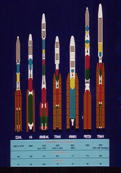
      The first American ICBM to become operational came from the Atlas family of missiles in October 1959, followed by the Titan I family of delivery vehicles in April 1962. 46  Apparently, the only non-reusable space launcher that did not derive from a military programme is the Saturn rocket family, the production of which was abandoned in 1975. Five major families of rockets are still operational: the Atlas, Delta, Pegasus, Scout, and Titan (see Table I.2.1). Most of these space launchers are available in two versions: military (for American use) and civil (for American and international markets). For example, American Titan-II and IV missiles are used as military launchers to place military satellites into orbit.

      Photo I.2.5: Delta II (US) [non disponible]


Photo I.2.6: Atlas Centaur (US)

Courtesy of NASA

      Among American commercial rockets is the air-launched Pegasus space launch booster, developed by Orbital Sciences Corp and Hercules Aerospace Company, although the booster was sponsored by the Defence Advanced Research Agency (DARPA). The Pegasus booster is attached to and launched from underneath the wing of a B-52 aircraft. Due to the sigh and launching of this rocket, Pegasus is only capable of launching small satellites into low Earth orbits (see Photo I.2.7). The first test flight of the Pegasus launcher was conducted successfully on 5 April 1990 (see Photo I.2.8).

      Photo I.2.7: Pegasus Space Launcher (US) [non disponible]


Photo I.2.8: Pegasus Test Flight (US)

Courtesy of NASA


Photo I.2.9: Trident II (D-5) Missile Test Launch at Cape Canaveral (US)

Courtesy of the US DoD

      Photo I.2.10: Trident II (D-5) Missile Test Launch at Sea (US) [non disponible]

Courtesy of the US DoD

      Photo I.2.11: Peacekeeper Missile in its Silo (US) [non disponible]
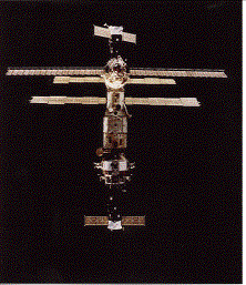
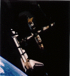
Courtesy of the US DoD

      The outer-space competence of the USA and the Russian Federation is such that they are the only countries to have successfully accomplished manned missions to the moon. They have also been successful in establishing and maintaining space stations in Earth orbit, particularly the Soviet Union's operation of the MIR station (see Photo I.2.12). In rocketry, they have developed different types of expandable space launchers as well as space shuttles. The Soviet placement of heavy loads in low orbit, Energiya, made it possible to launch the disassembled parts of a space station and the now suspended unmanned space shuttle Buran. 47  The latest generation of American space launchers is the reusable Space Transportation System, which includes the manned Space Shuttle (see Photo I.2.14). In contrast to its Russian counterpart, the Space Shuttle has been operational for almost two decades.


Photo I.2.12: MIR Station (Russian Federation)

Courtesy of Space Research Institute, Moscow


Photo I.2.13: Shuttle/MIR Docking

Courtesy of NASA

      
Table I.2.2: Selected Sounding Rocket/Space Launcher Technology Development by EtSC States: Level-I Countries
Country/ Rocket Rocket & Function Propulsion Type Capability (kg) Present Status
USSR-Russia        
Lance-Vostok 3 stages, SL Liquid 4,730 to Lo, 1,150
to Ho, 1,840 to Ss
Operational
Lance-Molnya 4 stages, SL Liquid 7,500 to Lo,18,000 to Se Operational
Lance-Soyouz 4 stages, SL Liquid 7,240 to Lo, 1,600
to Mo, 900 to Po
Operational
Lance-Kosmos 2 stages, SL Liquid 1,700 to 180 km,
1,000 to 800 km
Operational
SL-11 3 stages, SL Liquid 4,000 to Lo Operational
Tsyklon 3 stages, SL Liquid 4 000 to Lo Operational
Proton (D-1) 3 stages, SL Liquid 20,600 to Lo Operational
Proton (D-1-e) 4 stages, SL Liquid 2,500 to Go, 5,700
to Moon, 4,600 to
To
Operational
Zenit 2 stages, SL Liquid 13,740 to Lo,
11,380 to Ss, 2,500
to Go
Operational
Energiya 4 motors, SL Liquid, cryogenic 105,000 to Lo,
32,000 to Moon,
19,000 to Go
R&D
Energiya/Buran 4 motors, SSV Liquid, cryogenic 30,000 to Lo R&D
Volna 2, SL Liquid 430 kg to 200 km
185 kg to 700 km
R&D
Shtil-1 3, SL Liquid 265 kg to 200 km
90 kg to 700 km
R&D
Country/
Rocket
Rocket Body
& Function
Propulsion
Type
Capability
(kg)
Present
Status
Shtil-2 3, SL Liquid 410 kg to 200 km
220 kg to 700 km
R&D
Shtil-3 4, SL Liquid 950 kg to 200 km
730 kg to 700 km
R&D
Rif-MA 4, SL 1-3 Solid
4 liguid
1500 kg to 200 km
1200 kg to 700 km
R&D
Prioboy-1 4, SL 1 Solid
2-4 liquid
1700 kg to 200 km
1200 kg to 700 km
R&D
USA        
Scout G-1 4 stages, SL Solid 451 to 550 km Operational
Scout 2 4 stages, SL Solid 1,447 to To, 3,983
to Lo
Operational
Delta 3 stages, SL   1,819 to To, 5,039
to Lo
Operational
Delta-2 3 stages, SL Solid and liquid 2,340 to To, 5,900
to Lo
Operational
Atlas-1 2 stages, SL Liquid, cryogenic 2,770 to To, 6,780
to Lo
Operational
Atlas-2 2 stages, SL Liquid, cryogenic 2,900 to To, 7,120
to Lo
Operational
Atlas-2As 2 stages, SL Liquid, cryogenic 3,150 to To, 7,640
to Lo
Operational
Country/
Rocket
Rocket Body
& Function
Propulsion
Type
Capability
(kg)
Present
Status
Titan-2 3 stages, SL   2,177 to polar Lo Discontinued
Titan-34D 3 stages, SL Solid and
liquid
1,900 to Go,
12,500 to Lo
Operational
Titan-IV 3 stages, SL Solid and liquid 1,900 to Go,
12,500 to Lo
Operational soon

      Eo= Equatorial orbit; Go= Geostationary orbit; Ho= Helio-synchronous orbit; Lo= Low orbit; Po= Prognoz orbit; POLo= Polar orbit; Se= Semi-synchronous Elliptical Orbit; SCEs= Space-Competent States; SL= Space Launcher; Ss= Sun-synchronous orbit; SSV= Space Shuttle Vehicle; STS= Space Transportation System; To= Transfer orbit (Moon, Venus, Mars, or Deep space); ..= Data unavailable.

Source= Data compiled by the author partly in the light of information given in Roger Stanyard, World Satellite Survey, London, Lloyd's Aviation Department, 1987; Atlas de Géographie de L'espace. Sous la direction de Fernand Verger, Sides-Reclus, 1992, pp. 75, 81; Nicholas L. Johnson (ed.), The Soviet Year in Space: 1990, Colorado Springs: Teledyne Brown Engineering, 1991; Salvatori, Nicoletta, "Così un Sogno ha Potuto Mettere le Ali," Airone Spazio, Numero Speciale, n°. 120, Aprile 1991, pp. 109-21; Igor I. Velichko, Nikolai A. Obukhov, Georgy G. Sity, et al. "Launch Vehicles Using Submarine-Launched Ballistic Missiles Technologies," Space Bulletin, Vol. 2, N° 1, 1995, pp. 24-26, op. cit; and others.


Photo I.2.14: Space Shuttle (United States)

Courtesy of NASA

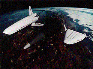
      R&D is also in progress to explore other, more-advanced types of reusable space transportation systems. New concepts and alternatives in space shuttles seek the development of regularly reusable vehicles, especially for low-orbit satellite launching. One case in point is the case of the Delta Clipper (DC-X) rocket concept initiated by DoD and now being tested by NASA (see Photo I.2.15), although it will be several years before such a system can be commercialized. 48  Other technology developments include work being done on the HL-20, a Personnel Launch System (PLS). HL-20 is a small space vehicle designed to transport up to 10 astronauts and small cargo to and from low Earth orbit (see Photo I.2.16). HL-20 is expected to be launched and landed much in the same way as the present Space Shuttle, but is a smaller vehicle minimizing both maintenance and cost. Other R&D worth noting here is the planned joint programme for a space station, supported by the USA, Russia, and a few other EtSC States, which the end of the Cold War and the reassessment of relationships and space programmes has now made feasible proposition.


Photo I.2.15: Delta Clipper Experiment (USA)

      Photo I.2.16: R&D on Space Vehicles (USA) a. PLS Experiment [non disponible]

      
From left: the Rockwell wing body 7, the McDonnell Douglas Vertical Landing and the Lockheed Martin Lifting Body configuration.


b. Other Reusable Launch Vehicles

Courtesy of NASA

      However, the Soviet space programme had been beset by financial and other problems since the mid-1980s. The dismantling of the Soviet Union in 1991 led to a fragmentation of its space institutions and industries, throwing a shadow on the future of Russian activities in outer space. 49  The Commonwealth of Independent States (CIS) has inherited the space capabilities of the former USSR, but the questionable stability of the CIS presupposes further dismantling of its space capabilities and an overall decrease in space activities. 50  Although this fragmentation is still continuing, 51  it seems safe to state that the Russian Federation's defence and space agencies have inherited most of the former Soviet capabilities in terms of outer space, BMs, Anti-Ballistic Missile (ABM) facilities, detection/tracking and launching sites, manufacturing capabilities and human resources. 52  Since the early 1990s, intensive rethinking on better utilization of space resources for both military and civil industries has guided the restructuring of Russia's space activities. 53 

      For example, of the three major launch sites and a few other test ranges from which the former Soviet Union operated its launch vehicles, two are located in the Russian Federation: the North Cosmodrome (originally Plesetsk) in the northwestern part of the Federation facing the Nordic states and the Kapustin Yar near the Volga River and city of the same name. Not all of the three launching sites were constructed as such, but they are usually identified as having been used as military bases for the launching of medium and/or intercontinental-range ballistic missiles. One of three Over-The-Horizon-Backscatters (OTH-B) near Nikolayevsk-na-Amur and a few of the eight long-range early-warning ABM-associated phased-array radars remain on Russian territory, as well as all of the eleven Hen-House series radars and the Pillbox phased-array radars. 54  Nevertheless, it should be noted that some key early-warning and space launch facilities, as well as manufacturing capabilities, are located in other former Soviet Republics. During a transitional period, facilities for strategic deterrent forces were reported in Western literature to be under CIS control, 55  although some analysts found it to be doubtful. At the same time, it was also reported that Belarus, Kazakstan, and the Ukraine had joint control of former Soviet strategic weapons and other devices located in their respective territories.


Figure I.2.1: Anti-Ballistic Missile Radar at Pushkino (Russian Federation)

Courtesy of the US DoD


Figure I.2.2: Galosh ABM Interceptor (Russian Federation)

Courtesy of the US DoD

      The Ukraine reportedly has two OTH-B radars (near Kiev and Komsomolsk) and one ABM-associated phased-array (near Mukachevo). 56  In addition, it has major manufacturing facilities for space launchers (the Tsiklon and the Zenit rockets), as well as electronic intelligence and early-warning application satellites and radars, of which the naval EORSAT spacecraft is more developed than others. 57  Kazakhstan has inherited the Baiconur Cosmodrome--renamed the Tyuratam Cosmodrome --situated east of the Aral Sea near the city of Leninsk in Central Asia, as well as the long-range phased-array Sary Shagan radar. 58  For its part, Belarus is known to possess manufacturing facilities for early-warning radars in the city of Gomel. 59  Different manufacturing capabilities are therefore spread-out in these three territories, none of which seems to possess a combination of satellites and ground launching/tracking facilities, although the Ukraine may be an exception. However, all of these independent republics have had different missiles (such as the SS-18, SS-19, SS-24, and SS-25) which could be converted into space launchers after some modification. However, given their respective stockpile, conversion, operation, and satellite assembly requirements, this option seems to be realistic only in the case of the Russian Federation.

      Unlike the Soviet programme, American activity has progressed. NASA has access to space-launch sites in both the continental United States and elsewhere. The biggest of these sites is Cape Canaveral, in Florida, which contains, among other things, a US Air Force base and the Kennedy Space Center. In California, NASA operates space launch/return flights from the Vanderberg and Edwards Air Force Bases. Vanderberg Air Force Base is used as a launch site, while Edwards AFB is used in conjunction with the Kennedy Space Center for the landing of the space shuttle. NASA also operates the Wallops Space Center located on Wallops Island in Virginia which, along with the Kennedy Space Center, is known primarily to operate sounding rocket launches. 60 

      In terms of dual-use tracking capabilities, the United States has developed a worldwide array of antennae and radars. 61  Among these are the ballistic missile early-warning systems in Alaska (Clear), Greenland (Thule), and the UK (Fylingdales Moor). Its radar at Fylingdales Moor, for example, has the primary task of providing early-warning of ICBMs and SLBMs and the secondary task of space surveillance. Thus, it plays an integral role in American satellite tracking capabilities. 62  In addition, ground-based phased-array radars and systems such as the Perimeter Acquisition Radar Attack Characterization System (PARCS) (Cavalier, North Dakota) and the PAVE PAWS radar (Massachusetts) are operated. Other space tracking radars include sites in Turkey (Pirinçlik) and Florida (Eglin); optical tracking systems in New Mexico, South Korea (Choejong-San), Italy (San Vito), Hawaii (Maui), and the Indian Ocean (Diego Garcia). Furthermore, the Ground-based, Electron-Optical Deep Space Surveillance System (GEODSS) operates in New Mexico (Socorro), South Korea (Taegu), Hawaii (Maui), and the Indian Ocean (Diego Garcia). The USA also operates three transmitting and six receiving stations for space surveillance in southeastern America as well as a number of other detection and tracking radars worldwide some of whose data could have dual-use - e.g., in the Pacific (Kwajalein Atoll), Atlantic (Ascending Island), Caribbean (Antigua), Hawaii (Kaena Point), and in Massachusetts (MIT Lincoln Laboratory).

      EtSC States in Category II have achieved considerable outer-space competence and are known as being well-established equipment, technology, and service supplier States. Indeed, the Soviet Union and the USA were not the only countries engaged in launching-vehicles R&D in the 1950s. One such country was China, which is known to have undertaken R&D on missiles modelled on foreign sources in the late 1950s--reportedly with Soviet technological assistance and some knowledge of the US missile programme. 63  Rocketry research, for instance, began in 1957 at the First Subacademy of the Fifth Academy of the Ministry of Defence. The China Academy of Launch Vehicle Technology (CALT) was established that year. In February 1960, the Chinese successfully launched their first sounding rocket. The T-7M, a small liquid-propellant rocket designed by the Shanghai Institute of Machine and Electricity of the Chinese Academy of Science, was followed in September of the same year by the "... first application type liquid meteorological rocket--the T-7.". Only a month later, the first Chinese short-range rocket was launched. After a series of small- and medium-sized rocket launches during the 1960s, 64  there was a preliminary intercontinental rocket launch in the early 1970s, but it was not until May 1980, nine years later, that the first full-range launch of this kind took place. 65 

      In civil activities, Chinese space launchers are indigenously-built. 66  The first generation, designated Chang Zheng (CZ) and also known as Long March (LM) rockets, placed China's first satellite into space in April 1970. 67  Since then, CZ rockets have evolved considerably. The CZ family, designed and produced by the Beijing Wanyaun Corporation, consists of three series of rockets (the CZ-1, 2, and 3), each series having different versions. The CZ-1 rocket was demonstrated in 1965, but came into service only in 1970. In 1974, a new CZ-2 two-stage liquid-fuel rocket series was put into service with the first and only launch of the CZ-2A. About two-thirds of China's launches from 1970 to 1990 were directed to low orbits, and the CZ-2C version has been used for 75% of these launches. A new rocket, the CZ-2E, was launched in July 1990, and both CZ-2 versions were still operational in 1994. CZ-2E is also a two-stage liquid-fuel rocket, but it has four additional strap-on motors designed to lift heavy and voluminous object into low orbit (see Photo I.2.17). 68 

      Geostationary orbit launches are effected with follow-on CZ-3 and CZ-4 rocket. CZ-3 rockets were put in service in 1984 and have been used for all subsequent launches to geostationary orbit, with the exception of the 1988 and 1990 CZ-4 launches. 69  In fact, the CZ-4 no longer appears in the CALT catalogue of launchers and the CZ-3 would appear to be the only high-orbit option available. However, China is planning to quadruple its satellite delivery capacity to geostationary orbits by developing two heavy-lift launchers, the CZ-3A and the CZ-2E/HO. Both have a three-stage body structure with liquid and cryogenic propulsion motors and both were marketed in 1994.

      Photo I.2.17: CZ-2E Space Launch (China) [non disponible]

Courtesy of CALT

      Like China, France has been active in outer space since the end of the 1940s. Rocketry research started in 1949, the year that the Véronique sounding-rocket first appeared. Construction of 15 AGI (International Geophysical Year) rockets was subsidized by the National Defence Scientific Steering Committee (CASDN) and the work was carried out by the Ballistic and Aerodynamics Laboratory at Vernon. French sounding-rocket activity began in March 1959; 70  three Véronique rockets were launched that year, eleven in 1960, and eight in 1961. These were followed by two Bélier and seven Centaure rockets in 1961, and in December of that year France decided to develop space launchers.

      Initially, research may have been oriented more to military requirements than to sounding rockets proper. France produced the Diamant space launcher, using technology originally designed for ground-to-ground ballistic systems--the Agate, Emeraude, Rubis, Saphir, and Topaze missiles. 71  Diamant launchers were constructed by the National Centre for Space Studies (CNES) and the Ministerial Armaments Delegation (DMA), via the transformation of the Saphir missile, with work undertaken by the Society for the Study and the Realization of Ballistic Vehicles (SEREB). The Diamant-A launcher was launched on 26 November 1965 from Hammaguir in the western Algerian Sahara, when it placed the 40 kg Astérix-1 satellite into orbit. 72  The Diamant-A successfully placed three other satellites (Diapason-1A in 1966 and Diadème 1 and 2 in 1967) from the same launch-site. France then decided, on 30 June 1967, to construct an improved version, the Diamant-B. Three years later, in March 1970, Diamant-B placed its first satellite into orbit--the German Wika satellite from the French Centre Spatial Guyanais French Guyana Space Centre (CSG), near the city of Kourou in Guyana. 73  Diamant-B made two other successful flights but ran into difficulty during its fourth and fifth flights in December 1971 and May 1973, respectively. The Diamant programme was formally abandoned on 14 December 1974, although work continued on a new version, the Diamant-BP4, which successfully achieved three launches in 1975.


Photo I.2.18: Ground-based Ballistic Missile (France)

SIRPA/ECPA


Photo I.2.19: Sea-Launched Ballistic Missile (France)

SIRPA/ECPA

      However, having terminated its independent launch-vehicle programme, France then directed its manufacturing capabilities to the creation of ESA's space launcher family. 74  It was only in the early 1990s, with the emerging need for low-cost launch vehicles, that French companies decided to create a new, comprehensive space-launching system. Reportedly, Aerospatiale is developing the ESL, which is a three-stage rocket capable of carrying satellites weighing up to 1,200 kg to an altitude of 550 km in polar orbit. ESL will probably operate out of the CSG and to be marketed shortly after the year 2000.

      The United Kingdom has an equally long involvement in rocketry and satellite R&D. 75  It developed the Skylark sounding rocket in the 1960s and its work on space launchers is linked to military programmes. For example, the Black Arrow space launcher (produced in the mid-1960s) is said to have derived from a mix of the Black Knight missile and the Skylark. 76  The Black Arrow was reportedly abandoned in the early 1970s after three launch failures, 77  and since then the United Kingdom has not pursued any further space-launch development.

      All three of the EtSC Level-II States mentioned above -- China, France and the United Kingdom -- possess BMs (see Table I.2.3), and BM R&D has played an important role in their space-launcher research. The CSS-2 Chinese BM, which belongs to the present generation of CSS ground-based missiles, became operational in the same year as the CZ-1 space launcher - 1970. 78  The CSS-3 and CSS-4 BMs became operational in 1978/79, the CSS-4 in 1981, and a submarine-launched BM, the CSS-N-3, in 1983/84. 79  With the exception of the CSS-4, all of these BMs have low Earth orbit capabilities. Reports indicate that two new missiles are under development: (1) a ground-based solid-propellant--the CSS-X-5, and (2) a SLBM--the CSS-NX-4. 80 

      In the area of early-warning BMs, China reportedly uses two tracking-station sites associated with phased-array radar complexes: the Xichang Satellite Launch Centre, which reportedly covers Central Asia, and the Shanxi site which is said to cover the northern border. 81  It is interesting to note that all of these sites are also used as China's three official space-booster sites.

      France, which achieved rocket launch capability in the mid-1960s, has continued to develop its BM capability. Its S-3D IRBM came into service in 1980 and is still operational. A new missile, the M5-S5, has been approved either as a new system or to replace the S-3D in the future. 82  Similarly to China, France's SLBM BM, the M-4, came into service after its ground-based counterpart - in 1985. 83  Little has appeared in the open literature on France's ground-based early-warning BM capability. It is known, however, that such capability has been mounted in the Henri Poincaré and the Le Monge. This is not surprising since the submarine section of the French nuclear forces is the pillar of its deterrence posture. After the Hammaguir launch-site was closed-down, France set up another launch-site at Kourou, where the ESA launches are carried out. 84 

      
Table I.2.3: Selected Ballistic Missile Technology Development by EtSC States: Level-II Countries
Country/Rocket No. of Stages Propulsion Range (Km) First in Service
         
Ground-based        
CSS-2 1 Liquid 2,700-3000 1970
CSS-3 2 Liquid 7000 1978/79
CSS-4 2 Liquid 15000 1981
Submarine-launched        
CSS-N-3 - - 2,200-3,000 1983/84
France        
Ground-based        
S-3D - - 3500 1980
M5-S5ð - -   R&D (2000)
Submarine-launched        
M-4 - - 5000 1985
M5-S5ð - -   R&D (2000)
United Kingdom        
Submarine-launched        
Polaris A-3TK 2 solid 4,600 (2,500) 1967
Trident II D5ð 3 solid > ; 4,000 nm R&D (mid-90s)

      EtSC= Established Space-Competent States; ð= Confirmed forthcoming deployment; ð= Probable forthcoming deployment; ..= Data unavailable.

      Source= Data compiled by the author partly from information given in Trident: Thirty Years of the Polaris Sales Agreement, Chief Strategic Systems Executive, United Kingdom: Crown -, May 1993; World Armaments and Disarmament, SIPRI Yearbook 1972, SIPRI, Almqvist & Wiksell: Stockholm, 1972; Ballistic Missile Proliferation: An Emerging Threat, 1992, Arlington: System Planning Corporation, 1992; and others.

      In contrast to China and France, the United Kingdom does not manufacture ground-based or submarine-launched BMs. The present generation of British BMs consists of the American-supplied Polaris missile family, first put into service in 1967, and a new family of missiles, the Trident II D5, is expected to become operational still in the 1990s. 85  The United Kingdom does not possess an adequately instrumented test-range for the tracking and telemetry of its BMs. Polaris and Trident test launches are therefore carried out in the USA at the Eastern Range off the coast of Florida. Since the UK does not have a space-launch centre, 86  early-warning BMs are carried out on its behalf through the American radar installation at the Fylingdales Moor site.

      Other EtSC States whose technological know-how has not been directly derived from BMs are Japan and ESA countries such as Germany, Norway, and Sweden. ESA and its subcontracting companies have become important rocketry participants.

      As regards Japan, its activity in space is overseen by the Space Activities Commission (SAC). 87  It is entrusted with a number of institutions, two of which merit special mention here: the Institute of Space and Astronautical Science (ISAS) 88  operating under the Ministry of Education (MOE), and the National Space Development Agency (NASDA), 89  which is an executive organization linked to the Science and Technology Agency (STA), the Ministry of Post and Telecommunications (MOPT), and the Ministry of Transport (MOT).

      ISAS is an inter-university research institute whose brief is to conduct and supervise research on sounding rockets, satellite launchers, scientific satellites, planetary probes, and scientific balloons. It also operates solid-fuel sounding rockets and space launchers. Its sounding-rocket experiments which began in the late 1950s have included the Kappa, Lambda, and S rocket series. 90  Most of ISAS's launches in the 1970s and 1980s were undertaken by the Mu, a three-stage rocket (with an optional fourth stage) using solid propellants in every stage (see Photo I.2.20). ISAS's next generation of rockets, the M-Vs resemble their predecessors in that they have three stages and use solid fuel. However, their lift-off capacity to low orbit will be more than double.


Photo I.2.20: ISAS M3SII Space Launcher (Japan)

Courtesy of ISAS

      NASDA's role is to develop, launch and track rockets and satellites rather than to operate educational programmes. NASDA's space launcher capability sprang from American Thor-Delta rocket technology: a three-stage rocket, called the N series, which was manufactured by Mitsubishi Heavy Industry in Japan. 91  The first and third stages of the N-1 series used American know-how, but the second stage was developed in Japan. The rocket was propelled by both liquid and solid fuel American motors. First launched in September 1975, the N-I remained operational until 1982. A second version, the N-II, was used for launches from 1980 to 1986. The origin of the technology changed however; the N-II's first stage and strap-on boosters were produced, under US licence, in Japan, while the second stage came from American Thor-Delta technology. The N series successfully placed 15 satellites into geostationary and other orbits.


Photo I.2.21: NASDA H-I Space Launcher (Japan)

Courtesy of NASDA

      The second generation of NASDA rockets is called the H series and, like the N series, they use combined American/Japanese technology. Lift-off capacity was considerably improved, but the first stage and the strap-on boosters were the same as the N-IIs. However, other major sub-systems such as a liquid hydrogen/liquid oxygen engine (LE-5), a third-stage solid rocket motor, and an improved internal guidance system are said to be products of NASDA technology. 92  This series was discontinued after the H-I rocket launch in early 1992. H series rockets have launched nine satellites, all successfully. The H-II follow-up version, was first used in September 1988 for flight tests and initiated regular flight on 4 February 1994, placing a Vehicle Evaluation Pay-load (VAP) spacecraft into an elliptical orbit and deploying the Orbital Re-entry Experiment (OREX) in circular orbit.

      NASDA's H-II rocket is entirely indigenously built. The launcher is lifted beyond the Earth's gravitational pull by a new liquid hydrogen/oxygen engine (LE-7), and two solid rocket boosters. It is propelled further into outer space by two liquid-fuelled stages. With increased thrust and accuracy, the H-II rocket was built not only to launch high-capacity satellites, but also to lift the future Japanese space minishuttle-- H-II Orbiting Plane (HOPE)--in the early 2000s (see Figure I.2.3).

      ISAS and NASDA do not operate from the same launch pad, despite the fact that they conduct only two launches each a year by agreement with the fishing industry. ISAS uses the Kagoshima Space Centre (KSC) located in Uchinoura-cho on Kyushu Island, off the coast of the Ohsumi Peninsula. 93  NASDA's space launchers lift off from Tanegashima Space Centre 94  on Tanegashima Island, 115 km south of the city of Kagoshima.


Figure I.2.3: Artist Concept of HOPE Space Shuttle (Japan)

(Courtesy of NASDA)

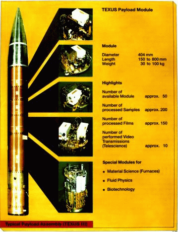
      Three other EtSC States have known rocketry capability. For example, in the mid-1970s, research undertaken by the German Space Agency (DARA), under the German Ministry of Research and Technology, 95  focused on sounding rocket manufacturing capabilities. 96  ERNO Raumfahrttechnik GmbH 97  took over the management of sounding-rocket programmes, developing, among others, the TEXUS sounding rocket, which is an exo-atmospheric rocket capable of carrying 250 kg of scientific experiments with a microgravity time of 6-7 minutes. In the late 1980s, ERNO also joined forces with the Swedish Space Corporation (SSC) to develop an even more powerful vehicle, 98  which resulted in the MAXUS sounding rocket (see Figure I.2.4). This uses a Castor IVB motor -- adapted from the American strap-on booster for the Delta II satellite launch vehicle -- and has more than twice the capability of the TEXUS. MAXUS can carry up to almost half a ton of scientific experiments in eight separate sections of its scientific payload-bay. It is available on the international market and has often been used by the ESA.


Figure I.2.4: MAXUS/TEXUS/MiniTESUS Sounding Rockets (Germany)

Courtesy of MBB/ERNO

      Sweden has also produced the MASER, an exo-atmospheric rocket which has technically similar features to the TEXUS. 99  MASER can carry 250 kg of scientific experiments to an altitude of just under 300 km and has a microgravity time of 6-7 minutes. The Swedish space programme has concentrated on the launching of sounding rockets and the operation of satellite ground-stations. Thus, in addition to the MAXUS and the MASER, Sweden has also launched sounding rockets from several other countries and stratospheric balloons from the ESRANGE site in northern Sweden, near Kiruna. 100 

      Norway is another Scandinavian country with an active launch programme. 101  The Royal Norwegian Council for Scientific and Industrial Research (NTNF) was established in January 1960 to promote sounding-rocket R&D. The creation of the Space Activity Division (SAD) within its ranks took place in 1965, but in June 1987 SAD was replaced by the Norwegian Space Centre (NSC). 102  Because of its geographical location, Norway has a long rocket history, the first launch being a Nike/Cajun rocket in August 1962; by the end of 1991, a total of 559 sounding rockets had been launched. 103  The NSC operates the Andøya Rocket Range (ARR) which has been used, under the ESA's special project arrangement, for rocketry programmes since 1972. In addition, the NSC also enables the Tromsø Satellite Station (TSS) in Tromsø to receive data from polar orbiting satellites.

      Italy has also been very active in rocketry since 1960, when Italy initiated both scientific research and a sounding-rocket programme. 104  This was followed, in 1962, by a co-operative programme between the Aerospace Research Centre of the University of Rome and NASA, for the development of a series of scientific satellites and launching capabilities. 105  This programme produced the first Italian satellite, the San Marco, which was launched in 1964 by a Scout vehicle. The programme also developed the San Marco range facility over two sea platforms. The range is located about 150 km miles north of Mombasa (Kenya), and consists of the San Marco Launching Pad and the Santa Rita Control Centre which are used to launch low equatorial orbit satellites. 106  However, it was only in 1979 that a National Space Plan (NSP) was created to promote outer space activities. In 1988, the Italian Space Agency (ASI) was established under the Ministry for the Universities and Science and Technology (MURST) to co-ordinate and manage NSP and Italian scientific and industrial participation in ESA and other international programmes. 107 

      Like Germany, Italy is much involved in the ESA's development of a space station module. For example, it is working on two Mini Pressurized Logistics Modules (MPLMs) for the transportation of user payloads and re-supply missions for the international space station. In addition, the Italian firm BPD has developed two generations of solid strap-on boosters for the European space launcher and a third generation of such boosters is being developed in co-operation with SEP, the French firm. 108  The Italians also produce qualified outer-space components for the American Space Shuttle such as the apogee motor--the solid-fuel Italian Research Interim Stage (IRIS). IRIS is also believed to be under study for possible use as a component for the third stage of the Chinese CZ-1M and other rockets. 109 


Photo I.2.22: Scout Launch Vehicle at San Marco

Courtesy of NASA


Photo I.2.23: Santa Rita and San Marco Platforms

Courtesy of NASA

      BPD has also initiated a feasibility analysis of the VEGA family of launch vehicles, 110  that could eventually include three different rocket versions: Capricornio BPD alternative, VEGA KO, and the VEGA K. VEGA vehicles are designed to carry satellites between 300 and 680 kg to various altitudes in low-Earth orbit (up to 550 km polar orbit). Furthermore, BPD has also, under joint Spanish/Italian industrial arrangements, proposed a specific vehicle configuration in the Spanish Capricornio launcher which is designed to carry spacecraft of up to 135 kg to 550 km polar orbit. While the BPD proposal would not increase this capability, it would provide an opportunity to utilize the company's new ZEFIRO rocket engine--a proposal that is reportedly also to be made to Aerospatiale for its new ELS vehicle.

      Most of the outer space technologies competence of the majority of Level II EtSC States are employed at ESA and ARIANESPACE. ESA regrouped the R&D work undertaken by its predecessors: the European Launcher Development Organization (ELDO) and the European Space Research Organization (ESRO). 111  ESRO developed sounding rockets (see Photo I.2.24) while ELDO developed Europe I and Europe II in the Europe rocket series between the mid-1960s and the early 1970s (see Photo I.2.25). 112  The Europe series launcher was a three-stage rocket combining mainly British (Black Knight), French (Diamant and Véronique), and German (third stage cryogenic propulsion) rocket technologies. A series of three flight tests of Europe I-F1 and F2 were made in 1964, all of them unsuccessfully.


Photo I.2.24: Sounding Rocket (ESRO)

Courtesy of ESA

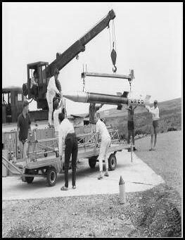
      Photo I.2.25: Europe I Space Launcher (ELDO) [non disponible]

Courtesy of ESA

      The next series, Europe II, was reportedly a modified version of its predecessor and basically designed for geostationary launches. 113  This series also failed, the last configuration tested being the Europe II-F11 rocket in 1971. Work on the subsequent Europe-III version was terminated on 30 April 1973 and one year later ELDO was dissolved. Despite this decision, ELDO had provided European countries with much experience in rocket technology. As a matter of fact, the present Ariane rocket series 114  (see Table .2.4) employed by ARIANESPACE 115  from the French launch-site at Kourou, originates in part from research on the Europe-III rocket initiated under ELDO and continued by ESRO.


Figure I.2.5: Ariane Space Launchers (Europe)

Courtesy of ESA


Figure I.2.6: Ariane 5 Multiple Mission Concept (Europe)

Courtesy of ESA

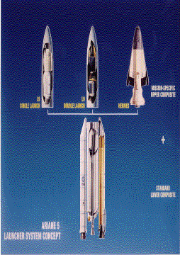
      Ariane 1 was first flown in December 1979 and the series has progressively evolved since then (see Figure I.2.5). The present rocket -- the Ariane 4 -- has solid/liquid/cryogenic-fuelled motors depending on which of its six versions is used to launch satellites for low and geostationary orbits. The next rocket in the series is expected to be a new generation vehicle with a radically different architecture. 116  Ariane 5 is expected to be capable of launching two large, or three smaller, satellites per launch when fully operational (see Figure I.2.6). Although its planned development was canceled, one other variation contemplated was the Ariane 5 HERMES, originally designed to place the now defunct European space shuttle, HERMES, into orbit. In addition, the first certification flight by Ariane 5, on 4 June 1996, was unsuccessful, but other follow on flights confirmed the vehicle's expected technological capabilities.

      
Table I.2.4: Selected Sounding Rocket/Space Launcher Technology Development by EtSC States: Level-II Countries
Country/ Rocket Rocket/ Function Propulsion Type Capability (kg) Status
China        
CZ-1 3 stages, SL Solid, liquid 700 to 300 km at 57ð Discontinued
CZ-1D 3 stages, SL Liquid, solid 750 to Lo Operational
CZ-1M 3 stages, SL Liquid   R&D
FB-1 2 stages, SL Liquid 2,800 to Lo/1,000 to Go Discontinued
CZ-2C 2 stages, SL Liquid 2,800 to Lo, 1,000 to Go Operational
CZ-2E 2 stages, SL Liquid 9,000 to Lo, 3,150 to Go Operational
CZ-2E/HO 3 stages, SL Liquid, cryogenic 4,800 to Go R&D
CZ-3 3 stages, SL Liquid, cryogenic 1,450 to Go Operational
CZ-3A 3 stages, SL Liquid, cryogenic 2,300 to Go R&D
CZ-4 3 stages, SL Liquid, cryogenic 1,500 to Ho, 4,000 to 200 km Operational
Europe        
Europe I¶¶ 3 stages, SL Liquid, cryogenic   Cancelled
Europe II-F11 3 stages, SL Liquid, cryogenic   Cancelled
Ariane 1 3 stages, SL Liquid, cryogenic 1,800 to Go Discontinued
Ariane 2 3 stages, SL Liquid, cryogenic 2,200 to Go Discontinued
Ariane 3 3 stages, SL Liquid, solid, and cryogenic 2,600 to Go Discontinued
Ariane 4
40
3 stages, SL Liquid, cryogenic 1,900 to To, 2,700 to
Ho, 4,270 to Lo
Operational
continue...        
Country/ Rocket Rocket/ Function Propulsion Type Capability (kg) Status
Ariane 4
44L
3 stages, SL Liquid, cryogenic 4,200 to To, 6,000 to Ho, 7,000 to Lo Operational
Ariane 5
L5 Double
2 stages, SL Liquid, cryogenic 6,800 to To, 12,000
to Ho, 7,000 to Lo
R&D
Hermès 2 stages, SSV cryogenic 22,000 to 90 km Suspended
France        
ESL 3 stages, SL   1200 to 550 km POLo- R&D
Germany        
TEXUS 1 stage, SR Solid 250 to 250-290 km Operational
MAXUS 1 stage, SR Solid 420-470 to 850 km Operational
Italy        
VEGA (KO) 2 stages, SL   300 to 550 km POLo R&D
VEGA (K) 2 stages, SL   680 to 550 km POLo R&D
Continues...        
Japan        
M-3S/M-3H 3 stages, SL Solid 300 to 250 km Suspended
M-4S 4 stages, SL Solid 180 to 250 km Suspended
M-3SII: 1/2 3 stages, SL Solid 770 to 250 km Operational
M-V 3 stages, SL Solid 1,800 to 250 km R&D
N-I 3 stages, SL Liquid 130 to Go Discontinued
N-II 3 stages, SL Solid, liquid and cryogenic 350 to Go Discontinued
continue...        
Country/ Rocket Rocket/ Function Propulsion Type Capability
(kg)
Status
H-I 3 stages, SL Solid, liquid and cryogenic 550 to Go Discontinued
H-II 2 stages, SL solid, cryogenic 2,000 to Go; 2to 3 ton probe to TO Operational
HOPE SSV boosted by H-II   R&D
Spain        
Capricornio 2 stages, SL   135 to 550 km POLo R&D
Capricornio¶¶¶ 2 stages, SL   130 to 550 km POLo R&D
Sweden        
MASER 1 stage, SR Solid 250 to 250-290 km Operational
MAXUS 1 stage, SR Solid 420-470 to 850 km Operational

      ¶= Joint venture between the ERNO Raumfahrttechnik GmbH and the Swedish Space Corporation (SSC); ¶¶= F1 to F9 and G1 to G2 versions; ¶¶¶= Proposed BPD alternative; CZ= Chang Zheng or Long March; FB= Feng Bao or Storm; Go= Geostationary orbit; Eo= Equatorial orbit; Ho= Helio-synchronous orbit; Lo= Low orbit; Mo= Molnya orbit; Po= Prognoz orbit; POLo= Polar orbit; EtSC= Established Space-Competent States; To= Transfer orbit (Moon, Venus, Mars, or Deep space); ..= Data unavailable.

Sources = Data compiled by the author partly on the basis of information given in China Academy of Launch Vehicle Technology, CALT, Beijing, 1991; Yang Chunfu, "China's LONG MARCH Series Carrier Rockets", Military World, May 1989, pp. 20-25; Atlas de Géographie de L'Espace. Sous la direction de Fernand Verger, Sides-Reclus, 1992, p. 81; "National Space Development Agency of Japan", NASDA Brochure, Japan, 1991; "National Space Development Agency of Japan", NASDA Brochure, Japan, 1992; Space in Japan: 1992, Research and Development Bureau, Science and Technology Agency, Keidanren, 1992, pp. 21-22; "Japanese National Report submitted to the Twenty-First Plenary Meeting of the ICSU Committee on Space Research", Japan, 1990; Institute of Space and Astronautical Science Activities, Japan, 1990; Microgravity MAXUS Brochure, Swedish Space Corporation; The European Space Agency, European Space Agency, Public Relations Division, Paris, June, 1992; "A European Success Story", 50th Launch Special, Ariane, European Space Agency, April 1992; Hermes, European Space Agency, ESA D/STS/H, May, 1991; ARIANESPACE: The World's First Commercial Space Transportation Company, ARIANESPACE, Evry, 1991; Balduccini, M., "BPD Hardware Development to Support Low Cost Missions", ESA Round-Table on "Space 2020', European Space Research and Technical Centre, European Space Agency, Noordwij, The Netherlands, 27-29 June 1995 and others.

      Information compiled in the open literature show that EtSC Level I and Level II States have made 3,395 successful space launches between the beginning of the space era and 1991. 117  (No such record seems to have been published after 1991. Despite this lack of available date, the information which follows is still pertinent, if only because it reflects most of the period of the space era.) As illustrated in Graph I.2.1, 2,315 of the launches (over 68%) for the period that data is available were conducted by the USSR, which made 80-100 launches a year between 1970 and 1978. Its successor, the Russian Federation, continues to be fairly active in space, despite some cutbacks overall. During the same period, the USA conducted 953 launches, or just over 28% of the total. No other State achieved successful triple-digit or double-digit figures per year.


Graph I.2.1: Reported EtSC States Successful Space Launches (1957-1991)

Source: Adapted from information given in Space Log: 1957-1991, International Space Year, 1992, TRW, 1992, p. 45; as well as information supplied by various space organizations of the respective countries.

      For example, the Japanese and the European programmes, which recorded the third highest successful figures during the same period, undertook only 43 operations each, or a little under 1.3% of the total. It should be noted, however, that Japan initiated operations only in 1970 and Europe in 1979. China conducted 29 launches, while the individual figures for Australia, France, and the United Kingdom were, respectively, 1, 10 and 1, making a joint total of 12 in all. 118 


2. Space-Based Devices

      The impressive record of development in the manufacture and operation of ballistic missiles and space launch vehicles discussed above is also indicative of the ability of the EtSC States to develop a number of other space-based devices. This is true for civil applications of artificial satellites, but also for their military uses. Dedicated and non-dedicated military satellites have played an important role in military preparedness and real-time battlefield operations for many of these States since the early 1960s. 119 

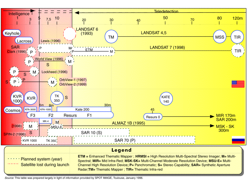
      As is the case for space launchers and ballistic missiles, the Soviet Union and the USA were the first to operate an array of satellites for different military applications. In photo reconnaissance, for example, experts generally believe that Russian space-based sensors have very high spatial resolution--in the order of centimetres. However, even today, there is little actually available in the open literature concerning Russian satellite application development--be it photo reconnaissance, early warning, or other military-related spacecraft. At time of writing, about six different types of cameras are believed to provide Russia with images from 300 m to less than 1 metre resolution in the Cosmos, Resurs, and other spacecraft configurations. The Resurs configuration provides images by collecting the data and returning the film back to Earth in the spacecraft which is then overhauled and re-used. These spacecraft are placed at altitudes of about 250 km into near-circular and near-polar orbits and usually have a very short life-span: about five Resurs spacecraft are launched annually. 120  Reportedly, Russia is now operating the newest (fifth or sixth generation) reconnaissance spacecraft of the NIKA satellite family. 121 

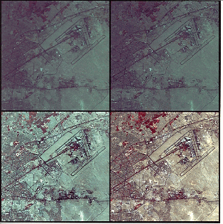
      There are more data on American military activity - for example, the KH [Key-Hole], Magnum, White Cloud and other satellites. KH satellites were launched in classified reconnaissance programmes such as the CORONA (August 1960), ARGON (May 1962) and LANYARD (July 1963). Images from the CORONA programme, including photos of cameras and the re-entry vehicle, were recently declassified, thus publicly revealing the development status of American reconnaissance spacecraft at the time. 122  For example, the KH-11 series has a ground resolution of 15.24 cm and is equipped with IR night-capable devices.


Figure I.2.7: CORONA Reconnaissance Satellite (USA)

Courtesy of NRO

      A more advanced series, the KH-11+/KH-12, has thermal-imaging and light-enhancement capabilities enabling night pictures to be taken, instant transmission imaging, and refuelling capability. The resolution of this series is suspected to be better than 15.24 cm. Other types of satellite are radar-imaging spacecraft, one example being the Lacrosse series which carries night/cloud cover-capable devices with reported ground resolutions of 60 cm to 3 m. As for navigation satellites, NAVSTAR is completely operational with a constellation of 24 spacecraft. The NAVSTAR--Global Positioning Satellite (GPS) provides navigation and positioning data to both military forces and the public civilian market worldwide. 123 


Figure I.2.8: CORONA Launching Sequence

Courtesy of NRO


Figure I.2.9: CORONA Recovery Sequence

Courtesy of NRO


Figure I.2.10: Artist View of NAVSTAR Satellite (USA)

Courtesy of NRO


Figure I.2.11: Artist View of Global Positioning System (USA)

Courtesy of NASA

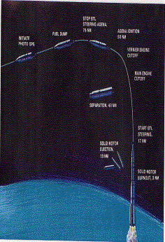
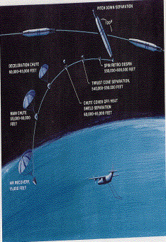
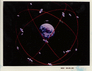
      Incentives to reach greater degrees of independence in outer space matters have also motivated other countries to develop their own space-based devices and most, if not all, Level II EtSC States have been able to produce different kinds of satellites for different applications although only a handful of these concern dedicated and non-dedicated military systems. One such country, however, is China. Satellite activities began in 1958 with the support of the military stimulating R&D 124 -- for example, the initiatives taken by the Fifth Research Academy of the Ministry of National Defence, which was already active at the time in the development of Chinese rockets. However, it was not until 1965, following the successful launch of a middle-range surface-to-surface missile, that an official proposal to construct and launch satellites was made. After the Commission of Science and Technology for National Defence (COSTND) had organized a feasibility demonstration study and submitted a report to the Central Special Committee (CSC), the Satellite Design Institute was created in September 1965 and China's first scientific experimental satellite, the DFH-1, was designed. In early 1967 the satellite programme was delayed because the general architecture of the spacecraft had to be modified to enable the song "The East is Red" to be broadcast. Since then, China has manufactured three major categories of spacecraft--scientific experimental, remote sensors, and communications satellites, some of which have been used for military purposes.

      Chinese remote-sensing satellites include Earth observation, technical experiment, and sun-synchronous orbit meteorological spacecraft. The Chinese Earth observation Fanhui Shi Weixing satellite, also known as Fanhui Shi Yao Gang Weixing, is a recoverable spacecraft. First generation satellites were launched in 1974 and, reportedly, second generation ones in 1992. 125  Like their Russian counterparts, these recoverable satellites also have a very low orbit of about 175 km for the perigee and 400 km for the apogee. They also have a short flight-life: the first generation satellites were able to stay in orbit for only 5-8 days, and their successors for 10-15 days. As of 1993, China was already working on its third generation system. Chinese remote-sensing satellites carry a visible light surface feature camera, but their spatial resolution has been kept secret. Nevertheless, in the early 1990s Chinese defence experts have indicated that China's satellites resolution levels were much better than those of civil-use satellites then. 126  This implied that Chinese sensors were able to provide data with resolutions equal to or better than 10 m. Nonetheless, if these experts were also taking Russian commercial satellite data into consideration, this meant that their imagery would be better than 2 m.

      The unique nature of satellites and their environment in general, but of remote sensing spacecraft in particular, is recognized in Chinese official documents. It is also acknowledged that "... recoverable remote sensing satellites had been widely used in national defence and economic constructions." 127  In addition, Chinese military authorities supported communications satellite R&D, 31 March 1975, the Standing Committee of the Central Military Commission (CMC) approved a report on the development of a Chinese communications satellite put forward by the State Planning Commission and the COSTND. This was promptly officially endorsed. Less than a decade later, in January 1984, China's first experimental communications satellite was launched.

      France took much longer than China to acquire military satellites. In photo reconnaissance, for example, France's HELIOS I spacecraft was launched by an Ariane-4 launcher on 7 April 1995. HELIOS I was a joint co-operative product between France, Italy, and Spain. 128  Although its ground resolution has not been published, some observers believe it to be in the order of 1-1.5 m. 129  It is possible that HELIOS I resolution is indeed much more than 1 m. HELIOS I provides Earth observation data for military manoeuvres and similar exercises. In addition, HELIOS I also gives France and its HELIOS partners the technological means to implement political decisions by using HELIOS data as their own NTM verification. It could also allow them to participate in selective or collective monitoring and verification of arms control and disarmament agreement as image providers.

      Figure I.2.12: Artist View of HELIOS I (France) [non disponible]

Courtesy of Matra Marconi Space

      Military-application satellites used by Level II EtSC States also include the dual-use of satellite platforms. For example, French civilian communication satellites carry military components on board or perform military or military-related assignments. TELECOM I and II, for example, carry SYRACUSE (Système de radio-communication utilisant un satellite) I and II, which are military payloads (one-sixth of TELECOM I, and a little less than 50% for its successor). 130  The same arrangement is true for the STENTOR satellite. 131  Similarly, the SIRIO satellite has been used by the Italian Navy for mobile communications, and SICRAL, an Italian multipurpose satellite, has been used for military purposes, national public security and civilian protection. 132  For its part, the United Kingdom has also manufactured dedicated satellites such as the SKYNET, which is a form of dedicated military communications network. Reports indicate that the United Kingdom is also developing a signals intelligent satellite called Zircon. 133 

      Graph I.2.2: Reported Military Satellite Launches 1985-1991 [non disponible]

      Intelligence = Imaging intelligence, electronic intelligence, naval intelligence, mapping and remote sensing, and weather satellites; Early-warning and Communications = Communications, navigation, and nuclear explosion detection; Satellite/Weapon Development = Ballistic missile development, ballistic missile defence, anti-tactic ballistic-missile defence, radar calibration, and geodetic; Other Missions = Space test programmes and minor military missions.

Source: Adapted from information published in the SIPRI Yearbook series (1986-1992)

      Some technologies have clearly been given more military priority than others during the period 1985-1991, as shown in Graph I.2.2. For this six-year period alone (for which data is available to the author), over 46% of the 700 military satellites placed in orbit were devoted to intelligence operations, with just under 42% concerning with early-warning and communications. Launches by the former USSR and the USA totaled almost 700--476 and 187, respectively - and no other country reached even double-digit launches during that period. As depicted in more detail in Graph I.2.3, the most active military applications have been intelligence imaging, representing 61.5% of all flights.


Graph I.2.3: Reported Intelligence Satellite Launches 1985-1991

Source: Adapted from information given in the SIPRI Yearbook series (1986-1992)

      The USSR devoted over two-thirds of its military intelligence activity to imaging satellites for the six-year period mentioned above while the USA emphasized naval intelligence, although they did strike a balance between imaging, electronic intelligence satellites, and weather applications. 134  China is the only other country to have reportedly launched imaging satellites. The military intelligence satellites launched by other countries have been limited to weather devices.

      In another area of activity, Graph I.2.4 shows how selective the launching of military satellites can be. It should be noted that the former USSR and the USA have launched an array of dedicated spacecraft as well as communication devices, notably early-warning and nuclear-explosion detection. To date, such devices have not been launched by any of the Level II EtSC States or EmSC States.

      Graph I.2.4: Reported Early-Warning and Communications Satellite Launches 1985-1991 [non disponible]

Source: Adapted from information published in the SIPRI Yearbook series (1986-1992)

      The technologies acquired by Level II EtSCs States has been internationally available, to at least some extent, for years. Technology transfer mostly occurs between major EtSC States. Even on the military side, entire BM systems have been sold internationally, as in the case of the British SLBMs. However, this did not happen with transfers to and from the former Soviet Union and countries then in the Soviet bloc. Co-operation in outer space and related activities between both Level I and Level II EtSC States is expanding and yesterday's potential enemies are emerging as tomorrow's probable partners. A new approach to co-operative programmes will therefore probably reshape the nature of the relationships between EtSC States.

      The priorities of the 1970s and 1980s are being revised to meet present requirements in Europe and growing financial constraints. Thus, communications (including broadcasting), observation (scientific research and Earth observation) satellites, probes for the Moon and also other planets, and man-in-space programmes involving, for example, space shuttles and permanent space stations have all been affected. A case in point is the international space station which is due to be completed in 2002 as the so- called Alpha configuration (see Figure I.2.13). 135 


Figure I.2.13: Artist View of the International Space Station (Alpha)

Courtesy of ESA, Photo ESA/D. Ducros

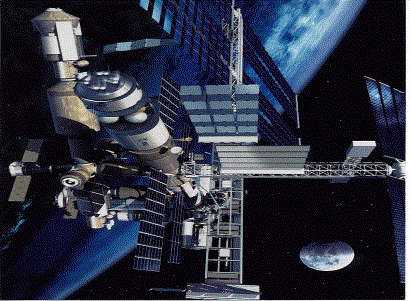
      In spite of these fundamental changes in perspective and behaviour, it is still uncertain as to how far co-operation between EtSC and EmSC States will develop in the future. While ad hoc and selective co-operation may still be envisaged, the dual-use nature of certain outer-space activities will, to some extent, condition comprehensive co-operation, particularly in the transfer of rocketry technology.


B. Emerging Space-Competent States: Technology-Recipient States

      In contrast to EtSC States, the Emerging Space-Competent States (EmSCs) have not yet mastered outer-space technology in all its aspects. Nevertheless they make considerable efforts to develop their qualified manufacturing capabilities. The number of EmSCs is small, but growing. Their major objective is to develop long-term political and development planning for autonomy, and eventually self-sufficiency, in highly specialized technology. This objective is also explained by a wish not to have to purchase American, Russian, European and, recently, Chinese or even Japanese spacewares, but to offer equipment and services in the international space market themselves.

      Among EmSCs are Argentina, Brazil, India, Israel, and Pakistan, although they are not all at the same level of development in space activities. Some EmSC States have already placed satellites in Earth orbit. Others are not so advanced but are already on the verge of testing indigenously-built space launchers. For example, India and Israel have already manufactured and launched sounding rockets and space launchers. Argentina and Brazil have still not developed launching technology, although they already operate satellites in Earth orbit. Nevertheless, with the exception of Argentina, all EmSC States have been seeking very intensively to close this gap.


1. The Quest to Reach Outer Space

      In many instances, the technology gap between established- and emerging-space-competent States is not necessarily due to a late start in outer space activities by EmSCs. Action in Argentina, for example, dates back to 1958, when sounding rockets were launched in the hills of Córdoba Province. 136  In 1960, a Presidential decree created the National Commission of Space Research (CNIE), 137  and rocket activity continued for 18 years. The CNIE, linked to the Secretariat for Science and Technology, also functioned under the auspices of the Air Force for over 30 years, although it was the Instituto de Investigaciones Aeronáuticas y Espaciales (IIAE) which served as the implementing agency for CNIE, by directing and developing a few specific rocketry programmes. The CNIE also participated, inter alia, in the EGANI, EXAMETNET, and EOLE projects in co-operation with companies from France, Germany, and the USA. 138  Experiments used sounding rockets to 400-km heights and involved Alfa Centaura, Orion, and Canopus rockets and balloons. In addition, indigenously-built Argentine rockets were also launched from the Wallops Station in the USA and from Peru and Antarctica. 139 

      In 1980, a propulsion systems project was created and the Alacran sounding rocket was developed. In addition, the CONDOR programme, also initiated in the early 1980s for the development of an indigenous sounding rocket, was perhaps the most important rocketry engagement undertaken by the CNIE. 140  CONDOR I was a sounding rocket and CONDOR II was expected to launch the Argentinean SAC-1 satellite. However, CNIE was replaced in March 1991 by the National Commission of Space Activities (CONAE), 141  which inherited most of the CNIE infrastructure and programmes including the CONDOR programme. By 1990, all Argentinian activity in sounding rockets and space launchers had ceased for political and economic reasons.

      Diagram I.2.A: Structure of Space Activity Institutions in Argentina [non disponible]

      In 1994, after its adherence to technology transfer controls, Argentina decided to produce a new generation of space launch vehicles. However, while considerable experience in sounding rockets has been acquired, it seems unlikely that Argentina will develop a space launch vehicle in less than a decade. Nonetheless, the new programme is planned to last from 1995 to 2006; 142  analysis and engineering design of a space vehicle for low-orbit launchers was due to begin in 1996 and last until the year 2000. Sub-system operation and testing were scheduled to run from 2001 to 2006 so that, if all goes well, it is expected that an Argentinian New Generation Space Vehicle (NGSV) could be operational within 10 years.

      Brazil has also been developing an industrial park in aeronautics and outer space since the creation, in 1961, of the Organizing Group of the National Commission for Space Activities (GOCNAE). 143  A sounding rocket programme initiated at the AVIBRAS Indústria Aeroespacial from 1965 to 1975 developed the SONDA rocket series--SONDA I, SONDA II-B and SONDA II-C. Reportedly, the SONDA programme utilized technology and components developed by both AVIBRAS and the Ministry of Aeronautics. 144  Starting in 1965, the two-stage SONDA I was used to test technology for solid propellants and short-range rockets, and over 200 SONDA I rockets were launched in a 12-year period . In 1966, work began on a single-stage SONDA II rocket for delivery of civil loads into earth orbit. SONDA II has also tested aerodynamic configuration and functioning during the separation stages. Since 1966, over 50 rockets have been launched in such areas as thermic protection, new propellants, aerodynamic configuration, and electronic components testing. 145 

      Work began on a two-stage SONDA III rocket for the study of magnetic anomaly in the South Atlantic in 1969 and over 20 of these rockets have been launched since then. In 1974, a bi-stage SONDA IV rocket was produced to test the major propulsion components of a future satellite launch vehicle (VLS), whose development was officially approved with the creation in 1981 of the Brazilian Complete Space Mission (MECB) programme. 146  The creation of the Brazilian Space Agency (BSA) in February 1994 and the approval of the Brazilian National Policy on the Development of Space Activities (PNDAE) in December of the same year endorsed the initial development of a space launcher. 147  The VLS has SONDA IV technology and uses a four-stage solid-propelled rocket. It is designed to place satellites weighing between 100 and 200 kg in a circular orbit of 250-1000 km (see Figure I.2.14). 148 


Figure I.2.14: Artist View of the SONDA Sounding Rockets and the VLS Space Launcher (Brazil)

Courtesy of CTA/IAE

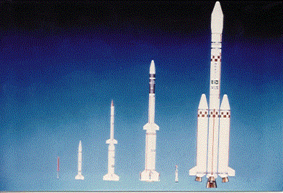
      Different versions of SONDA rockets have been constructed for the VLS. Although the VLS-R1 failed a test flight in 1987 (reportedly because of gyroscope guidance technology problems), the VLS-R2 version subsequently completed a test flight successfully. In addition, a two-stage rocket, the VS-40, consisting of a combination of stages from existing sounding rockets, is under construction for propulsion tests in a vacuum chamber. Although there have been several delays in construction, the vehicle was fully mounted in 1996 and underwent tests at IAE (see Photo I.2.26). The first launch of the Brazilian VLS vehicle took place in 1997, resulting in a failure when the vehicle was destroyed a few moments after it was take off. The VLS programme is expected to continue and four other vehicles are scheduled to be built.

      Photo I.2.26: VLS Space Launcher Undergoing Test (Brazil) [non diposnible]

Courtesy of CTA/IAE

      Brazil is also considering the production of a second-generation space-launcher, the Light Space Transport [Transporte Espacial Leve] (TEL). 149  In 1995, a feasibility study was approved for a vehicle capable of launching a 500-kg satellite up to 2,000 km. The vehicle would consist of a Brazilian solid-propellant booster added to a main liquid-propellant rocket acquired abroad, and is expected to be developed with foreign assistance between 1997 and 2002. It is believed that the vehicle could be financially viable for launching prospective Brazilian and other small low-orbit satellites in the next 15 years. In addition, the need for communications satellites is encouraging the development of a more-powerful vehicle to place satellites in geostationary orbit. Such a project could generate additional revenue and make the country's space launch site a more financially viable investment.

      In Israel, another EmSC State, activity related to outer space began in 1966 with the creation of the Space Research Institute at Tel-Aviv University. 150  Seventeen years later, in 1983, the Israel Space Agency (ISA) was set up under the Ministry of Science and Technology, since then outer-space-qualified launching capabilities for low Earth orbits have been developed.

      Unlike the Brazilian SLV, the Israeli booster has already made successful space launches. The launcher, called Shavit or Comet (see Photo I.2.27), reportedly originates from the solid propelled, one-stage, road-mobile Jericho missile, which is itself a product of French/Israeli co-operation in the late 1960s. 151  After the 1967 War, further development of the Jericho series is said to have become indigenous, and it was then that the Israel Aircraft Industries (IAI) would have introduced a second stage to the road-mobile missile's body, thus creating Jericho II BM, which enhanced both the range and payload capacity. 152  After different versions of Jericho II, Israel produced Jericho III, although the Shavit space launcher is believed to have inherited most of its technical characteristics from Jericho II. A third stage was added to the vehicle which constitutes the present configuration of the space launcher. The first- generation of the Shavit space launcher was launched three times, in 1988, 1990, and 1995, respectively.


Photo I.2.27: SHAVIT Space Launcher (Israel)

Courtesy of the Israeli Aircraft Industries International INC

      A new generation launcher designed for the international market is reportedly under consideration. 153  Analysts believe that Israel's bid to enter this market may also seek international co-operation to provide different rocket motors or stages for a multinationally-built launcher. Such commercial strategies are part of a trend being pursued by both established- and emerging-space-competent States, with the objective to provide services for the demand to launch small satellites in the next century.

      Another EmSC State of interest is India, its outer space programme has focused on sounding-rocket and space-launcher capabilities from the mid-1960s onwards. 154  One important development was the establishment of the Vikram Sarabhai Space Centre (VSSC) at Thumba, Thiruvananthapuram, which concentrates on indigenous sounding-rockets, space-launchers, and associated technologies, 155  including the Rohini (RH) rocket. The first rocket in this series, the RH-75, was launched in 1967 and there has been continuous development of follow-on versions. For instance, the RH-200 Single Stage Version (SSV) rocket has been successfully tested and another version--the RH-200 Dual Trust (DT) motor--was developed. Work on an even more advanced version, the RH-300, has been completed and is available for scientific experiments. However, at one point the flight of India's most advanced sounding-rocket, the RH-560, was said to be unsatisfactory, but scaled-down requirements have shown the rocket to be effective and it is therefore extensively used. 156  All RH rockets use solid propellent.

      Development of space launchers has been undertaken by the Indian Space Research Organization (ISRO) at its Trivandrum facility and includes four rocket types designated as Satellite Launch Vehicle (SLV-3), Augmented Satellite Launch Vehicle (ASLV), Geostationary Satellite Launch Vehicle (GSLV), and Polar Satellite Launch Vehicle (PSLV) (see Table I.2.5). 157  India's first indigenous space-launcher, the SLV-3, made four experimental flights between 1979 and 1983, the first (in 1979) being a failure but those in1980, 1981, and 1983 were considered as partly or fully successful. However, the SLV space-launcher is no longer being manufactured.

      There were other problems, such as the flight failures of the ASLV-D1 rocket in 1987 and the ASLV-D2 in 1988. After modification, an ASLV-D3 successfully placed a 110-kg Rohini satellite in orbit on 20 May 1992. The ASLV-D4 was also successfully launched two years later, on 4 May 1994, injecting a SROSS-C2 113-kg satellite into a near-Earth orbit (see Photo I.2.28). 158  While the ASLV-D4 has not yet been officially declared operational, it has been designed to prove a number of technologies that are required for PSLV and the GSLV missions: "[all the objectives of the ASLV programme have been realised." 159  It was therefore launched as an evaluation test flight to analyse, inter alia, (a) its performance in placing a satellite in low-Earth orbit (close to 500 km); (b) its closed-loop guidance system; and (c) its four-stage spin-up system. 160 

      In the case of the PSLV, however, the technology is quite different from the SLV-3 and the ASLV series, with the exception of the strap-on boosters. In fact, the four- stage rocket uses both SLV-3 solid-fuel boosters and Ariane technology liquid fuel motors. 161  The first PSLV flight, on 30 September 1993, failed owing to "... an error in the implementation of on-board software." 162  The second, the PSLV-D2, was launched on 15 October 1994 and successfully placed an Indian remote-sensing satellite in orbit (see Photo I.2.29). 163 

      Photo I.2.28: ASLV-D4 Space Launcher (India) [non diponible]

Courtesy of ISRO

      Photo I.2.29: PSLV Space Launcher (India) [non diponsible]

Courtesy of ISRO

      In respect of geostationary rockets, the GSLV configuration derives from the PSLV launcher. GSLV vehicles should replace the six solid-propellant strap-on boosters of the PSLV with four liquid strap-on motors. The third and fourth stages of the PSLV (solid and liquid fuel stages) are replaced by a single cryogenic fuel stage. 164  Manufacturing of the rocket system, sub-systems, and motors are were completed and the first flight test in October 1994 was successful.

      Last but not least is the rocketry research being undertaken by Pakistan. It began in 1961 with the establishment of the country's Space and Upper Atmosphere Research Committee. 165  A major Pakistani sounding-rocket programme was the construction of a vehicle using a mixture of indigenous and imported technology, the latter originating mostly from NASA, CNES, and BNSC [British National Space Centre] in the early 1960s. 166  For example, the first Pakistani sounding-rocket, the REHBAR-I, was launched from its Flight Test Range (FTR) at Sonmiani on 7 June 1962. 167  The construction of the SUPARCO Plant in 1968 168  provided Pakistan with facilities for building sounding-rockets and instrumentation for rocket-borne and ground-based applications. The first reported Pakistani-built sounding-rocket, a two-stage solid-propellant rocket named REHNUMA-1, was launched in 1969 from the FTR. This rocket was capable of carrying a 35-kg payload up to 160 km. A heavier version, although also a two-stage solid-propellant vehicle, the SHAHPAR, boosted Pakistani sounding-rocket capability to a 55-kg payload up to 450 km.

      Pakistan's sounding-rocket programme consists of four main missions using different configurations of its SHAHPAR vehicle (see Photo I.2.30). 169  One is used to study wind structures by reaching altitudes between 20 and 65 km. A second mission consists of launching a sounding-rocket with a dozen grenades which are ejected at altitudes between 25 and 60 km and exploded at pre-determined heights for studies on wind speed, temperature, and pressure. The third mission involves the launching of sounding-rockets to an altitude between 90 and 135 km to compute wind speed and direction, and a fourth mission will eject sodium vapours at altitudes between 200 and 400 km, also for atmospheric studies. In addition to these missions, Pakistan is also capable of lifting "... scientific payloads weighing 30-50 kg to altitudes up to 500 km". 170 


Photo: I.2.30: SHAHPAR Sounding Rocket (Pakistan)

Courtesy of SUPARCO

      Official documents make no mention of any intention by Pakistan to develop space-launcher capability. However, experts in the West believe that Pakistan does intend to lift light to medium-size satellites into low Earth orbits. The first launch of a three-stage rocket meeting these parameters reportedly took place in 1989.

      
Table I.2.5: Select Sounding Rocket/Space Launcher Technology Development by EmSC States
Country/ Rocket Rocket/Function ropulsion Type Capability(kg) Development Stage
Argentina        
Alacran 1 stage, SR Solid 250-300 km Cancelled
CONDOR I 1 stage, SR Solid 50 kg to 400 km Cancelled
NGSV     Low orbit A&C/FS
Brazil        
SONDA I 2 stages, SR Solid 60-75 km Operational
SONDA II 1 stage, SR Solid 70 kg to 100 km Operational
SONDA III 2 stages, SR Solid 50-80 kg to 500 km 130-160 kg to 300 km Operational
SONDA IV 2 stages, SR, SL Solid 500 kg to 600 km R&D
VS40 2 stages, SR Solid 60 km R&D
VLS 4 stages, SL Solid 200 kg to 1 000 km R&D
TEL   Solid & Liquid 500 kg to 2000 km A&C/FS
India        
RH-75 SR      
RH-125 SR      
RH-200 2 stages, SR Solid 10 kg to 80 km Operational
RH-200 DT, SSV SR      
RH-300 1 stage, SR Solid 50 kg to 140 km Operational
continued..        
Country/ Rocket Rocket/Function Propulsion Type Capability
(kg)
Development
Stage
RH-300 MK-II 1 stage, SR Solid 58 kg to 58 km  
RH-560 2 stages, SR Solid 100 kg to 350 km Operational
M-100 SR      
SLV-3 4 stages, SL Solid 40 kg to 400 km Discontinued
ASLV-D1, D2, D3, D4 5 stages, SL Solid 150 kg to 400 km R&D
PSLV-D1, D2, D3 4 stages, SL Solid: 1,3 stages
Liquid: 2,4 stages
1 000-900 km Spo R&D
GSLV 3 stages, SL Solid, cryogenic 2 500 to GSTo R&D
Israel        
Shavit 3 stages, SL Solid 156-250 kg to 1 000 km Operational
NGSV 3 stages, SL Solid 300 kg to Spo A&C/FS
Pakistan        
REHBAR-I 2 stages, SR Solid   Discontinued
REHNUMA 2 stages, SR Solid 35 kg up to 160 km Discontinued
SHAHPAR 1 stages, SR
stages, SR
Solid 135 km
55 kg to 450 km
30-50 kg to 200-500 km
Operational
(SLV) 3 stages, SL Solid. Low orbit R&D

      ¶ = Estimates made when launched from the Palmachim site and directed westward against the Earth's gravitational pull; A&C/FS = Analysis and Conception phase or Feasibility Study; ASLV = Augmented Satellite Launch Vehicle; ESCSs = Emerging Space-competent States; GSLV = Geostationary Satellite Launch Vehicle; GSTo = Geosynchronous transfer orbit; PSLV = Polar Satellite Launch Vehicle; NGSV = New Generation Space Vehicle; RH = Rohini; SLV = Satellite Launch Vehicle; Spo = Sun-Synchronous Polar orbit; SR = Sounding Rocket; SL = Space Launcher; VLS = Veiculo Lançador de Satélites; .. = Data unavailable; () = Not confirmed.

Source = Data compiled by the author partly in the light of information given in Aaron Karp, "Ballistic Missile Proliferation", World Armaments and Disarmament, SIPRI Yearbook: 1991, SIPRI, Oxford University Press, 1991; "Brazilian Space Program",Centro Técnico Aeroespacial, Instituto de Atividades Espaciais Brochure, Ministry of Aeronautics, Department of Research and Development, São José dos Campos; Brazilian Space Program: Sounding Rockets and Satellite Launcher Vehicle, Aerospace Technical Centre, Ministry of Aeronautics, São José dos Campos; 1991-92 Annual Report, Government of India, Department of Space, Institute of Space Research Organization, Bangalore, 1992; Space India, Volume I, Publication of the Indian Space Research Organisation, January-March 1988; Atlas de Géographie de L'Espace, op. cit., p. 93; John Simpson, Philip Acton and Simon Crowe, "The Israeli Satellite Launch: Capabilities, intentions and implications", Space Policy, vol. 5, No. 2, May 1989, pp. 117-128; Salim Mehmud, "Pakistan's Space Programme", Space Policy, vol. 5, No. 8, August 1989, pp. 217-225; and others.

      The above discussion clearly shows that it is difficult to compare the history EmSC States' sounding-rocket and space-launching activities with that of the major space-faring nations. Nevertheless, EmSC States do have, overall, significant rocketry experience, but it is difficult to ascertain the total number of sounding-rocket activities that these States have carried out so far. However, as Graph I.2.5 illustrates, sounding-rocket activities were expected to remain constant between 1994 and the year 2000 for all of these countries. Although this forecast depended greatly on the evolution of experimental scientific demands (which changes rapidly according to needs), it is interesting to note that India was expected to lead these countries with a planned 20 launches a year which, in one way, is indicative of the country's active effort to develop outer-space technologies. Taken together, the EmSC States reported here were expected to launch at least 26 sounding-rockets a year, giving a total of over 180 launches between 1994 and the year 2000.


Graph I.2.5: Select EmSC States Successful Sounding Rocket Launches and Forecast (1994-2000)

Source: Adapted from data provided by the space organizations of the countries concerned

      Unlike sounding-rockets, past and future space launches are easier to calculate so that projections can be much more accurate. Accordingly, Graph I.2.6 shows the space-launching activities already undertaken by EmSC States and a projection of what they are expected to do between 1995 and the year 2000. This graph highlights three important facts. First, EmSC States activity is still quite recent. Second, future trends predict a quantitative increase in both the launches themselves and the total number of States involved. While three countries made six launches between 1980 and 1991 (i.e., 11 years), it is predicted that four countries will carry out 16 launches in just over 5 years which is undoubtedly a quantum jump in launching activities by EmSC States.

      Thirdly, among the EmSC States, India is also in the lead in space launching. It was expected to carry out twice as many launches as Brazil and more than any of the reported forecasts for any other EmSC State. It should also be noted that, on aggregate, when the number of expected launches from 1995 until the end of the present decade is added to sounding-rocket activity, the total number of rocket launches forecast for that period is considerable: 200.


Graph I.2.6: Number of EmSC States Successful Launches and Forecast (1980-2000)

Source: Adapted from data provided by the space organizations of the countries concerned

      Unlike the major space-faring nations, EmSCs have few rocket launch-sites - about ten in all. Argentina has operated from two launch-sites: one, named Galopus, and the other, the Falda del Carmen, situated in the Province of Córdoba. The latter site was restored in 1995, but since Argentina no longer has an operational rocketry programme, neither of these sites is scheduled for further space activity. Nevertheless, if at least one of the country's national launching bases were modified to meet launching standards, Argentina could still be able to provide launching services on the international market.

      Brazil operates two launching-sites. 171  One is the Air Force's "Barreira do Inferno" - Hell's Barrier - installation near the city of Natal in the State of Rio Grande do Norte, which was previously used as a SONDA rocket test-site and still used for foreign rocket launching. However, for different technical and institutional reasons, it will not be used to launch VLS rockets for commercial purposes, and this has led to the construction of the Alcântara Launch Centre (CLA), a new launch-site in the State of Maranhão.

      India operates the TERLS sounding-rocket launch centre in South India and another, the Balasore Range, in the northwestern part of the country. India also operates a space launch-site called the Sriharikota Space Centre (SHAR), about 100 km north of Madras in the Bay of Bengal. SHAR is used for launching remote-sensing and communications satellites, as well as the production of solid propellants for space launchers. In addition, launch ranges at Balasore and Thumba are used by SHAR for space launches. Israel operates a launching site at Palmachim, a military base south of Tel-Aviv. Pakistan launches its sounding-rockets from the Flight Test Range (FTR), situated approximately 50 km northwest of Karachi at Sonmiani Beach on the shores of the Arabian Sea.

      Developing, testing, and launching sounding rockets and space boosters is closely related to R&D on BMs. In contrast to the EtSC States which have used BM technology to develop most of their space boosters, EmSC States have generally inversed this policy so that their BM programmes are usually the product of space-booster technology. This is apparently the case with the Argentinian CONDOR rocket, which often appears in the specialized literature under the BM heading. Indeed, it has been reported that Argentina developed the CONDOR II missile in 1984 from the CONDOR I sounding rocket. 172  This was seen by many other States as ballistic missile proliferation, not only because the development of the CONDOR II was launched under the auspices of the Air Force, but also because details on its progress and finance were largely placed under a veil of military-like secrecy. Nevertheless, the Argentinian Government has maintained that it was developing a space booster and not a missile.

      CONDOR I's first public appearance was at the Paris Bourget Air and Space show in 1985. The rocket had a special guidance system and was able to propel 50 kg up to a distance of 400 km. The follow-up CONDOR II version, however, was believed by different experts actually to be a two-stage missile with solid and liquid-propelled motors capable of reaching up to 600 km with a 500-kg payload. It was also a mobile missile using a Wegman-type launching base, but it is thought that it was never actually launched. A third missile, the CONDOR II Plus, was capable of doubling the distance carrying the same payload (see Table I.2.6).

      By 1988, the CONDOR project had run into budgetary problems and Argentina started work on a joint missile project with Egypt. After encountering technical problems and international pressure, President Menem's Government decided to halt the CONDOR programme and announced its legal termination in April 1990. 173  However, some CONDOR II tubes were found in Iraq during the 1991 Gulf War. These were thought to be filled with propulsion material, but the Argentinians argued that they were actually maquettes filled with sugar which had been delivered to Egypt, not Iraq. The discovery gave extra impetus to MTCR members, the USA in particular, to call for the destruction of the Argentinian missiles and their means of production. While Argentina found no difficulty with the elimination of the missiles and their accessories, the destruction of its industrial assets did create a problem and it took considerable high level negotiations to reevaluate the initial idea. The missiles and their parts (filled and empty tubes, liquid stages, etc.) were sent by cargo ship to a NATO base in Spain, since when their whereabouts are unknown.

      Thus, Argentina's missile production capability was brought to an end. New efforts are underway to develop a new generation of space vehicle which should, inter alia, ensure "...full transparency..." 174  and be "...in accordance with Argentinian policies on non-proliferation and with the international commitments [it has] assumedðin this matter", "ðrejecting any military offensive use of space activities." 175 

      BM R&D in Brazil has apparently also followed the space booster-to-BM route, developments in the SONDA rocket series being frequently related to private developments regarding BMs. 176  The most controversial missile projects suspected to benefit from SONDA technology were the AVIBRAS SS series (SS-150, SS-300, and SS-1000) and the ORBITA Sistemas Aeroespaciais, S.A., MB series (MB/EE-150, MB/EE-300, MB/EE-600, and MB/EE-1000). Because of the experience and credibility AVIBRAS enjoys in the field of military rocketry, many analysts expected that the SS-300 and the SS-1000 could have been the first Brazilian short- and mid-range ballistic missiles. However, all of the missile projects from both of the above-mentioned companies that were suspected of being SONDA-technology based were either cancelled or temporarily suspended (see Table I.2.6), reportedly because of a shortage of finance and confirmed orders. 177 

      India is another EmSC State where the civil space effort has been reported to have received some spin-off from on military programmes, despite the fact that the Indian civil and military programmes are run by distinct agencies operating under different civil and military ministries. This is particularly true in the case of the AGNI missile, 178  which is a two-stage solid- and liquid-propelled rocket produced by the Integrated Guided Missile Development Programme (IGMDP) by the Indian Defence Research and Development Laboratory (DRDL) of the Defence Research and Development Organization (DRDO). It is a nuclear-capable, intermediate-range ballistic missile, with a first solid-fuelled stage which is said to be similar to the SLV-3 space launcher. 179  In addition, the missile's on-board computer-guided technology was also reported in the mid-90s to be similar to that used in the Indian launch vehicle. 180  The spin-off argument is further strengthened by the fact that Dr A.P.J. Abdul Kalam, former director of the SLV-3 rocket programme, became Director of the IGMDP at Hyderabad in June 1982, and the AGNI missile programme was initiated shortly thereafter.

      The AGNI missile was successfully flight tested on 22 May 1989, but a second launch failed owing to premature ignition of the second liquid stage. Although problems were reported in connection with a third flight on 19 January 1994 at the Chandipur-on-Sea test range in Orissa, the test seems to have successfully validated the missile's re-entry technology, in that the missile's stage separation system and an advanced manoeuvring-type warhead are said to have been tracked by radar until it hit its target at sea 1200 km into the Bay of Bengal. 181  The development flights of Prithvi, a single-stage rocket propelled with liquid-fuel were successful as from 1988. Final approval for mass production of the Prithvi (SS-150) was given by the Indian Government in March 1994. 182  Prithvi was believed to be an operational missile in the mid-to-late 1990s. It is reported that a test flight of a longer version of the Prithvi missile was successfully made in 1996. 183  It was launched from a test site on the Orissa coast into the Bay of Bengal and noted in newspapers as being the fifteenth in a series since 1988 and to have boosted the vehicle's range beyond 160 km.

      Several military analysts believe that Pakistan's missile development originates, in part, from its sounding rocket facilities, but this development is not entirely indigenous and may also derive from Chinese, French, or Soviet technologies. 184  The French sounding rockets Dauphin, Dragon III, and the Eridan, and the Chinese ship-to shore missile SL-2, in particular, are presumed to be involved. Pakistan is believed to be developing three missiles in the designated Hatf missile family, each with different performances and ranges. The first in the series, Hatf-1, is a single-stage, short-range nuclear-capable rocket. The other two, Haft-2 and 3, are both two-stage, ballistic trajectory rockets believed to be nuclear-capable - particularly Haft-3, which is estimated to have an 800-km range with a 500-kg payload. 185  While Haft-1 is believed to have been operationally deployed as of 1992, Haft-2 is reportedly still under development. Research and development on Haft-3 are apparently still at the design and configuration stage and the missile is not expected to be operational or deployed before the late-1990s.

      However, although Pakistan seems to have acquired BM technology, it is generally believed that the country has sufficient facilities to manufacture only a limited quantity of Haft 1 and 2 missiles. Nevertheless, it is also thought that the industry itself requires further development before production on a large scale can be envisaged--for example, the manufacture of critical raw materials for propellant production and major testing of the rocket motors and the missiles themselves. 186 

      
Table I.2.6: Select Sounding Rocket/Space Launcher Technologies-Derived Missile Developments by EmSC States
Country/
Missile
No. of
Stages
Propulsion
Type
Payload
Capability & Range
Stage of
Development
ARGENTINA        
CONDOR I 1 Solid 50 kg to 400 km Cancelled
CONDOR II 2 Solid, liquid 500 kg to 600 km Cancelled
CONDOR II Plus 2 Solid, liquid 500 kg to 1000/1100 km Cancelled
BRAZIL        
SS-150 1 Solid 150 km Suspended
SS-300 1 Solid 300 km Suspended
SS-1000   Solid 1000 km Suspended
MB/EE-150   Solid 150 km Suspended
MB/EE-300   Solid 300 km Suspended
MB/EE-600   Solid 600 km Suspended
MB/EE-1000   Solid 1,000 km Suspended
INDIA        
Prithvi 1 Liquid 1,000 kg to 250 km In service (1994)ð
Agni 2 Solid, Liquid 1,000 kg to 2,500 km Under development
PAKISTAN      
Haft-1 1 Solid 500 kg to 60 km In service (1992)ð
Haft-2 2 Solid 500 kg to 280 km Under development
Haft-3 2 Solid 500 kg to 800 km Under development

      ¶= All missile payload capabilities and ranges are based on estimates from various sources; ð= Estimated deployment year.

Source = Data compiled by the author partly from information given in Chandrashekar, S., "An Assessment of Pakistan's Missile Programme", unpublished, 1992; Aaron Karp, "Ballistic Missile Proliferation", World Armaments and Disarmament, SIPRI Yearbook: 1991, SIPRI, Oxford University Press, 1991, p. 337; Vivek Raghuvanshi, "Prithvi Gives India Non-Nuclear Punch", Defense News, 7-13 March 1994, p. 12; The Nonproliferation Review, Spring-Summer 1994, vol. 1, No. 3, Monterey: Monterey Institute of International Studies, 1994, pp. 84-7; and others.

      As discussed above, the development of BMs in Israel, in contrast to other EmSC States, is said to have been the origin of the country's space booster. In addition to the five EmSC States already mentioned, other States, or private companies, with a lower technology level, are identified as having made links between space launch programmes and BM development. Africa and the Middle East are the regions where such links have been most evident--for example, space boosters and BMs in South Africa, which are reportedly linked to equipment and technology supplied by Israel. 187 

      In the case of Iraq, however, the alleged existence of a launcher programme, which pre-dated the 1991 Gulf War, appeared to be a mixture of missile and space booster technologies. 188  Some analysts argue that Iraq has never had a fully-fledged civilian space-launch programme. Others maintain that Iraq did have space-launcher ambitions. This latter argument is often sustained by the test launch of the so-called Tamouz 1 space launcher in 1989 from the Al Anbar Launch Centre. Apparently, Tamouz 1 was a triple-stage liquid-propelled rocket, which reportedly used the first stage of the Al Aabed missile. 189 

      Photo I.2.31: UNSCOM Inspection of Destroyed Ballistic Missiles (Iraq) [non disponible]

Courtesy of the United Nations, Photo 159121 / H. Arvidsson

      However, the Gulf War had two major repercussions on Iraq's ability to develop space launch capability. One was the Allied bombing of Iraq's industrial complex. The impact of the war on Iraq's rocket launch manufacturing capability should not be seen only as a matter of hardware destruction, but also from the standpoint of Iraq's capability to access capital for both rocketry and non-rocketry-related investment

      The second impact on Iraq's launch development programme is the implementation of UN Security Council Resolution 687. 190  Its objective is the destruction or neutralization of all of Iraq's BMs whose range is more than 150 km, and all principal BM components as well as their production and maintenance installations. Accordingly, both Iraq itself and the United Nations Special Commission (UNSCOM) have destroyed items used or intended for use in prohibited missile activities.

      Photo I.2.32: Chemical Agent Missile Warhead Sampling (Iraq) [non disponible]

Courtesy of the United Nations, Photo 158637 / Shankar Kunhambu

      For example, Iraq has announced the unilateral destruction of several BMs and this has been verified by UNSCOM inspectors, as may be seen from Photo I.2.31 which shows a UN inspection team looking at the remains of BMs destroyed by Iraq. Iraq has also said that it has destroyed Al-Hussein chemical-fill missile warheads. Photo I.2.32 shows an Iraqi worker in protective gear climbing into a chemical agent missile warhead so that the warhead can be opened for sampling by UNSCOM inspectors. The UNSCOM team also verified the destruction of missile launchers, decoy missiles, decoy missile launchers and missile support vehicles (see Photos I.2.33 and 34).


Photo I.2.33: Destroyed Decoy SCUD Launcher (Iraq)

Courtesy of the United Nations, Photo 159167 / H. Arvidsson

      The UNSCOM team has also supervised and verified the destruction of production equipment and buildings associated with the BM programme, such as madrels used in the production of solid fuel and rocket propellent for the BADR 2000 BM, and material used in the production of BM nozzles. Inspection of the destruction of solid propellant mixer storage facilities and missile-motor case preparation buildings was also carried out, as shown in Photos I.2.34 and 35.


Photo I.2.34: Destroyed Ballistic Missile Fuel and Oxidizer Vehicles (Iraq)

Courtesy of the United Nations, Photo 159169 / H. Arvidsson

      Photo I.2.35: Destroyed Missile-motor Case Preparation Building (Iraq) [non disponible]

Courtesy of the United Nations, Photo 159127 / H. Arvidsson

      Surveillance cameras have been installed at various missile test facilities for long-term monitoring, and in view of the complexity and time span needed to develop rocket- launch production, Iraq is not expected to possess such capability until well into the next century.


Photo I.2.36: Destroyed Solid Rocket Propellant Mixer Storage (Iraq)


2. Satellite Capabilities

      Satellite R&D is another area in which EmSC States have made considerable technological progress. However, it should be noted that, unlike their rocketry activities, most of the EmSC States did not start national R&D programmes until the 1980s. For example, although Argentina initiated satellite activities under CNIE auspices at the beginning of the decade, it was only in 1988 that a project known as SAC-1 (Scientific Applications Satellite-1) was set up with the aim of developing a small scientific satellite for placement in orbit by an American SCOUT rocket. 191  SAC-1 later became the SAC-B project where CONAE and NASA developed a scientific satellite to carry both Argentinian and American scientific devices. CONAE's role was to build the platform and structure and to operate the ground segment. 192  SAC-B was expected to stay in orbit for three years, but the satellite which was launched by the Pegasus launcher October 1996 remained attached to the last stage of the launcher.


Photo I.2.37: SAC-B Satellite (Argentina)

Courtesy of CONAE

      In 1994, there was a major shift in Argentina's space activities when the CONAE proposal for an 11-year National Space Plan (1995-2006) was adopted. 193  The plan endorses the SAC project and includes remote sensing and communications missions. Three satellites (SAC-C, D, and E) were scheduled to be manufactured and launched in 1998, 2001, and 2004, respectively. 194  For remote sensing, SAC-C and D will carry Multi Spectral-Medium-Resolutions Scanner (MMRS) cameras, although the exact resolution is not yet known. A series of communications satellites are also due to be launched early in the new millennium: SAOCOM-1 [Satellites for Observation and Communications] in 2000, SAOCOM-2 in 2003, and SAOCOM-3 in 2006. Some of these will also carry radar systems. 195  Other plans include the possible development of the SABIA Earth observation satellite with Brazil and the CESAR spacecraft with Spain.

      In Brazil, indigenous satellite development also began at the beginning of the 1980s. Four satellites are to be designed, developed, integrated, tested, and operated by the National Institute for Space Research (INPE) 196  within the MECB programme. 197  Two of these four satellites are designed to collect environmental data 198 --the SCD1 (see Photo 1.44) and SCD2 [Data Collecting Satellite or SCD]--and the other two will conduct remote-sensing operations--the SSR1 and SSR2 [Remote Sensing of the Earth or SSR]. 199  Although scheduled for 1989, delay in completing the Brazilian VLS meant that the SCD1 launch by an American Pegasus rocket had to be postponed until February 1993. The SCD2, which contained several design and component innovations, was also ready for launch before the completion of the Brazilian space launcher. The SCD2 satellite was lost during the unsuccessful flight of the VLS in 1997.

      In addition to the SSR1 and SSR2 series, further remote-sensing activity was envisaged after Brazil concluded an agreement, on 6 July 1988, with the People's Republic of China--the China-Brazil Earth Resources Satellites (CBERS)--to set up a programme of co-operation which included, inter alia, the development of two Earth imaging satellites. 200  CBERS 1 is expected to provide spatial resolutions between 20 and 260 m with three different sensors, one of which is a 20-m CCD [Charge Coupled Device] sensor. A second is an 80-m Infra-Red Multispectral Scanner (IR-MSS) for panchromatic and medium infra-red bands with 160 m for the thermal band. And the third is a Wide-Field Imager (WFI)--260 m. 201  The agreement called for CBERS 1 to be launched by a Long March Chinese rocket from the Shanxi launch-site and the satellite should have an expected lifespan of approximately two years to be replaced by the CBERS 2 spacecraft.

      The approval of a feasibility study of CBERS C and D may ensure the future of the series. Of particular importance are the optical sensors are these satellites, which would have image resolutions in the order of 1-2 m. 202  Other objectives in achieving indigenous satellite production capability include R&D in such areas as inertial platforms and gyroscopes, and atmospheric re-entry. 203  In addition, a programme has been approved under which Brazilian and American institutions will provide a radar satellite to look after environmental issues in the Amazon region. 204 

      Photo I.2.38: Data-Collecting Satellite 1 (Brazil) [non disponible]

Courtesy of INPE

      With regard to communications satellites, the purpose of the ECO-8 project is to manufacture and launch 8-10 (two spares) small spacecraft by the planned TEL vehicle. 205  The ECO-8 concept was conceived to cover an equatorial area of approximately 2000 km encompassing not only Brazil but also parts of Africa, Australia, and Asia. In all, the project was designed to launch a constellation of 32 small satellites during 14 years. ECO-8 was also expected to be merged with the American Bell Atlantic International and Constellation Communications, Inc. (CCI) System to form the Equatorial Constellation Communications (ECCO) system of 12 spacecraft, which would also enlarge the reach of the original satellite constellation. 206 


Photo I.2.39: OFEQ Experimental Satellite (Israel)

Courtesy of the Israeli Aircraft Industries International INC

      Three generations of spacecraft have been developed in Israel, 207  the first being an indigenous experimental satellite. A joint ISA/IAI venture drew up the OFEQ satellite programme, which led to the launching of the first Israeli-built spacecraft, the 156-kg OFEQ-1 or Horizon-1, on 19 September 1988 by a Shavit rocket. The satellite remained in orbit for three months testing the functional ability of its sub-systems and providing Israel with qualified platform design for follow-on generations. The second Israeli satellite, the OFEQ-2, was launched, again by a Shavit rocket, on 3 April 1990 and remained in orbit until July. 208  The Advanced OFEQ satellites are scientific spacecraft which conduct various experiments in the outer space environment and unlike the short life-span of their predecessors they are expected to remain in orbit for several years


Photo I.2.40: AMOS Satellite (Israel)

Courtesy of the Israeli Aircraft Industries International INC

      Third generation technology is concerned with the development of geostationary communications and reconnaissance satellites. One such satellite, approved in June 1989, and developed by the IAI, is the AMOS communications satellite. AMOS was launched on 16 of May 1996. A second spacecraft is the Israeli Institute of Technology's TECHSAT satellite. This was launched--unsuccessfully--by a Russian Start-1 rocket on 28 March 1994 and the satellite was lost. 209  OFEQ-3, a R&D and reconnaissance spacecraft, was launched by an Israeli launcher on 5 April 1995. 210 

      Pakistan is also involved in R&D on satellite programmes, although to a much lesser degree than the other EmSC States. The main objective is to be able to design and build small communication and remote-sensing satellites, 211  hence Pakistan's efforts to indigenously design and develop the country's first spacecraft--BADR-1. A light-weight (70-kg) scientific satellite for experimental communication, the BADR-1 was launched by a Chinese CZ-E2 rocket on 16 July 1990 and remained operational for 35 days. Another programme for a small second-generation satellite (50 kg), for low Earth orbit applications, the BADR-B, was developed. 212  The BADR-B carried a CCD Earth imager to operate at an altitude of about 800 km.

      A second programme, focused on telecommunications and television broadcasting, is the Domestic Communication Satellite System (PAKSAT), a project backed by private industry. Originally, it was to manufacture and launch two satellites positioned in geostationary orbit, one active, the other with in-orbit spare status. 213  However, little information is available on the development of PAKSAT's present architecture.


Photo I.2.41: BADR-1 Satellite with its Ejection Mechanism (Pakistan)

Courtesy of SUPARCO

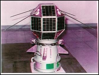
      Other satellite activities include SUPARCO's operation of satellite ground-stations; 214  the one at Islamabad receives LANDSAT, SPOT, and NOAA [the National Oceanic and Atmospheric Administration] data. Pakistan is also actively involved in international projects such as the ARGOS Network and the COSPAS-SAT programme. SUPARCO is also active in radio and optical tracking.

      Because India started satellite R&D in the 1970s, it has the most diversified programme of all the EmSC States in both the number and type of spacecraft produced. 215  India placed the Rohini Satellite 1 (RS-1) in orbit in 1980, the RS-2 in 1981, and the RS-3 in 1983. First-generation Indian satellites belong to the Indian National Satellite (INSAT) series, and the first such craft, INSAT-1B, developed by the American Ford Aerospace Company, was launched with a US STS in 1983, although operated by Indian ground facilities. Its successor, the INSAT-1C was launched in 1988 but, for technical reasons, became inoperable in the same year. The INSAT-1 series ended with the launch by Ariane of INSAT-1D in June 1990.


Figure I.2.15: Artist View of the INSAT-2B Satellite (India)

Courtesy of ISRO

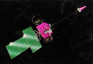
      The new generation of Indian satellites consists of INSAT-2, the Indian Remote-Sensing Satellite (IRS), and the Stretched Rohini Satellite Series (SROSS), all of which are indigenously-built spacecraft. 216  The launching of the INSAT-2A on 10 July 1992 by an Ariane booster marked a major milestone in the ISRO programme. INSAT-2A is a multipurpose satellite carrying high-power S-band TV transponders, 18 C-band transponders, and a very high resolution meteorological radiometer. 217  INSAT-2B carried instruments similar to its predecessor when launched by Ariane on 23 July 1993. More-advanced follow-on spacecraft such as the INSAT-2C, INSAT-2D and INSAT-2E are being developed and plans for a third generation (INSAT-3) have been announced. These are all planned to be launched by an Indian GSLV vehicle.

      Development of indigenous remote-sensing capability, including synthetic aperture radar, has been considerable. The IRS-1A [Indian Remote Sensing] was launched by a Soviet Proton rocket in March 1988, and the follow-on IRS-1B in August 1991 by a Vostok vehicle. Both satellites carried a Liner Imaging Self-Scanner (LISS-II), which operates in the visible and near infra-red regions of the optical spectrum. A third version, the IRS-1E, was lost through PSLV launch failure in September 1993. IRS-P2 (Photo 1.50), which carries an Earth imager with similar capability, was successfully launched on 15 October 1994 by an Indian rocket. The second generation IRS-1C and IRS-1D was launched in late-1997. The IRS-C is much more advanced than its predecessors and has a spatial resolution of 5.8 m, thereby privileging India in the commercial imagery market.

      However, the SROSS programme has encountered misfortune unrelated to the satellite's performance. The SROSS-A and SROSS-B, for example, were victims of failures by the ASLV space launcher, although the rocket successfully placed an SROSS-C2 in orbit in May 1994.

      As shown in Table I.2.7, EmSC States have overall developed (or are on the verge of doing so) satellite manufacturing capability for different applications, giving priority to communications and Earth observation. Other technologies, such as environmental monitoring and ground-based tracking, are also quite promising which, coupled with launching vehicles, has propelled the EmSC countries on to the international commercial market. However, this also causes concern about military activity and possible dual use.

      Photo I.2.42: IRS3-P2 Satellite (India) [non disponible]

Courtesy of ISRO

      
Table I.2.7: EmSC States - Satellite and Related Manufacturing Capabilities
Country Satellite Applications
Commun./
Broadcasting
Earth
bservation
Meteo-rology Scientific/Test Environ-
mental Data
Ground
Site
Argentina # #   @   o
Brazil # @ @   @ &
India @ @ @     &
Israel @ @   @   o
Pakistan @ @   @    
¶= Some satellites and their corresponding launch and tracking sites are not given owing to the absence of official State acknowledgment; @= At least one spacecraft (a) has been developed or (b) is under development; #= Development programme approved; ð= Related technology being developed; o= One ground-to-space tracking station; &= Two or more ground-to-space tracking stations; ..= Data unavailable.

Source = Complied from information given in Péricles Gasparini Alves, Access to Outer Space Technologies: Implications for International Security, UNIDIR, United Nations Publication, 1992; and others.

3. Access to Outer Space Capabilities: Challenges Ahead

      The preceding discussion has described the significant differences between Established and Emerging Space-Competent States, in terms of the scope of their outer-space activities and technology programmes. While EmSC States have mastered or are about to master activities such as sounding-rocket launches or launches to low orbits, only India appears to have attained the capability to boost rockets to geostationary orbit or indeed deep space.

      A second observation is that, as a rule, EmSC States are still developing small satellites (smallsats) weighing a few hundred kilograms with rather limited applications and life-spans. Again, India is an exception in that it has designed and developed larger multiple-application spacecraft. Israel has also significantly developed its military satellites.

      A third feature of EmSC States is that they have set up ground-control centres to receive, process, and disseminate national and foreign satellite data, with India again having the most ambitious programme of all. So far no EmSC State is involved in a major co-operation programme with an EtSC State of the magnitude of the Alpha International Space Station, India did send an astronaut into space with the Soyuz T-11 in 1984. It has also developed and produced solid and liquid propellants for both sounding rockets and space launchers.

      There is little doubt that the competence acquired by the EmSC States includes the basic technology for the military use of space boosters and development of missiles, particularly ballistic vehicles. However, the magnitude of EmSC States' BM programmes and the extent to which technology has moved from the civil to the military sector is less clearly identifiable than for EtSC States. Furthermore, most of the civil satellites that are capable of producing militarily-relevant data are owned by the major EtSC States. Thus, there is a clear gap between EtSC States and the new manufacturers in respect of both daylight sensors and infra-red devices and radars, and the acquisition of manufacturing capability for military-type space-based sensors by EmSC States constitutes a significant shortcoming.

      Nevertheless, in a broader sense, EmSC States appear to aim to have a footing in the international market for the sale of qualified outer space products, technologies and services. For the time being however, most of these States are only recipients of such commodities, their production capability being still unproven. As for the EtSC States, they too are also continuing to develop civil and military equipment and space applications. Given this evolving situation, it is worth noting that the possession and transfer of dual-use outer-space technologies pose at least three major challenges to the international community:


A. Civil and Military Uses of Outer Space Technologies

      Although it can be argued that technology itself is neutral, the use that is made of it can be detrimental to peace and security. For every one of the three areas of space exploration (launching, satellite, and tracking), there are dedicated military assets and civil systems that can be and are used for military purposes. Therefore, there is an urgent need to identify all the implications that access to outer space technology by both established and emerging space-competent States might have for international security. Since there is some technical distinction between the different launch vehicles, there is also a difference in their civil or military missions. This is less so in the case of satellites and Earth-tracking devices. Moreover, it is not only equipment and material that can be used for dual purposes, it is also the data they that they provide and the services which must accompany their use.

      Hence there is a need to assess the role that outer space technology plays in the restructurization of armed forces worldwide. It is not enough to know how these technologies can enhance war fighting capabilities; it is essential to know how these technologies can improve preventive diplomacy, conflict prevention, and conflict resolution. It is also vital to consider how space technology can contribute to the design and implementation of a durable new world order.


B. Technology Transfers and Control Regimes

      Non-proliferation is a central concern in the international security debate and outer space technologies are some of the significant components of that debate. That there is a gap in space competence between the EtSC and the EmSC States stems, in part, from the history of space technology development, it also reflects the development divide between industrialized countries and developing countries. Why does the experience of EtSC States make them resist opening up routes for technology transfer? How and why does the dual use of outer space technologies affect the EtSC States' non-proliferation strategies? Is the link between the development of BMs and space launchers, satellites and detection technology the only issue governing EtSC States' technology transfer policies; or are other political or economic considerations involved?

      An understanding of the issues at stake will help the international community to:

  1. address the military, political, and other aspects of non-proliferation;
  2. draw up realistic and practical multilateral action on technology transfer to close the gap between EtSC and EmSC States; and
  3. develop a multilateral agreement to ensure the transfer of space technology without undermining regional or global peace and security.

C. Liberalization of Military-Grade Goods

      As has already been stated, the commercial, civilian use of military assets, technologies, and services is an important factor in non-proliferation discussion. The end of the Cold War has had a fundamental impact on international relations. Access to outer space technologies can boost co-operation and sustainable development, but to address this challenge military spin-off activities in space and related sectors will need to be identified. This is already being implemented in such areas as the use of decommissioned BMs as commercial sounding rockets and space launchers. Another potential initiative could be a search for new synergies between military and civil uses of outer space.

      Such a search could also stimulate innovation and competitiveness. However, the most revolutionary aspect appears to relate more to end-use products and their users rather than to new equipment, where the objective is to develop a new culture in the use of space technology, equipment, and services. Promising initiatives with high future potential include synergy with industrial, scientific and traditional defence-oriented applications. The major challenge is to strike a balance between the search for new initiatives whereby the space industry and other sectors would attempt to penetrate the social fabric with improved and original services, and the danger that uncontrolled access to military-grade goods could pose if used by outlawed groups and individuals (e.g., terrorist and guerrilla groups, organized crime, etc.).


Part II
Increasing Access to Dual-Use Outer Space Technologies: Military, Geo-Political and Other Implications

      Following the discussion on the development of dual-use technologies and capabilities, Part II is an analysis of the military and strategic implications of the spread of these technologies in regional but also in a wider context, particularly the different types and BMs basing-modes--such as range and payload. In view of the recent fundamentally and strategically important geo-political changes, the implications for military doctrines and the perception of deterrent postures by different States are also the subject of appraisal.

      In addition to effecting purely military and strategic issues, real or suspected development of BMs also have implications to political and diplomatic security debates. How, therefore, do developments in BM capability affect regional security? Because of the range of some of these missiles, it is also important to assess the extent to which global security could be affected. Moreover, what effect could the spread of BMs have on existing and future arms limitation and disarmament agreements in general, and the Non-Proliferation Treaty (NPT) in particular? Where nuclear-threshold countries which are emerging space-competent states are involved, the question has even greater importance.

      Attention is also paid to the fact that an increasing number of States are now able to manufacture satellites and the implications this might have for international security. By increasing both horizontal and vertical access to BM capability, fundamentally aspects of war-fighting and war-prevention doctrines are undergoing changes. For example, satellite telecommunication links and imagery data are revolutionizing tactical military operations by bringing the battlefield "closer" both for communication to individual soldiers and visually to general staffs. Of special importance is the role that widespread access to satellite imagery data may play in arms limitation and disarmament verification and/or monitoring mechanisms. To this may be added the increased diversity of resources on which any international agency could draw to launch satellites or to assist the implementation of related tasks, such as the building of both confidence and security in outer space activities. Here the much debated do these issues (such as satellite trajectography and space debris surveillance capability) merit special attention.

      Last but not least are the economic implications of outer-space technologies themselves, be they dual-use or not. Just like the traditional space-competent states, EmSC States also find the international market an appealing sales outlet for their products and expertise, not only because of the need to recover some of the investment made in R&D, but also in respect of the commercial returns of conversion from military to civil applications.

      There is no doubt that the spread of outer space technologies is a highly complex and challenging issue, involving various events with uncertain results which might conflict with international security and peace. Yet, the spread of outer space technologies carries its load of constructive developments which should be singled out from the web of political, military and economic problems. Therefore, the objective of the present section is to sort out these and mixed interests and identify their complementarity in that they have a direct or indirect relationship to the central theme of this paper: the transfer of dual-use outer-space technologies.


1. Military and Geo-Political Developments

      Motivation to acquire dual-use outer-space technology can be based on various factors. One is the development of space and industrial parks. Another is the degree of military-relevant systems considered necessary for strategic security. However, the predefined objectives and technical constraints inherent in the technologies themselves may be limiting factors in the development of dual-use outer-space technologies. Tho these factors is added the issue of costs. For example, the production of launching vehicles and/or space-based devices may take precedence over ground-based radars and other sensors since, in purely military terms, the latter would have little value for a State which does not possess ballistic missile or satellite capabilities. The contrary would apply, however, for States whose military doctrines dictate the development of early-warning systems. Moreover, possessing or being perceived to possess dual-use assets such as BMs carries a number of implications other than military, since geo-political consequences are also an essential element of the security equation.

      Geo-political implications are rarely predictable, since there are no predefined patterns between one situation and another, or between one region and another. In the past, most geo-political analyses considered both the rationale and the values of political-military situations inherited from the Cold War. Now, a reconceptualization of regional security calls for a new approach in deciding the order of priorities. Does past and present possession of BMs indicate that there is a need to produce them? There is no easy answer, especially when the only point of reference is potential confrontation. In such a case, the "old" order of States' relations would still be valid. A departure from this reasoning would be naïve since, in this context, the wish to respond to technology transfer needs would be inhibited by security requirements. Thus, while the need to find alternative ways of addressing the situation is clear, this cannot be done without fully understanding what type of order of State's relation would replace the past or present one.


A. The Increasing Access to Ballistic Missiles

      In the past, the acquisition of BMs had clear implications for both global and regional security. Globally, Soviet/American technological production in the late 1950s led to an arms race in BM delivery systems. Since then, BM capability has become an increasingly important factor in military thinking and force structure, and in strategic and theatre contingency planning for land, sea and air forces, so that BM warhead delivery has profoundly affected the evolution of national nuclear and conventional doctrines, in war-fighting and deterrence for both war-prevention and first-strike/retaliation potential.

      For example, two of the three legs of the superpowers' nuclear triads are serviced by BMs. Prior to the existence of BMs, nuclear deterrence posture was based on deep-penetration of aircraft to deliver a payload by an air-dropping means as happened during the Second World War and for most of the following decade. However, the appearance of BMs in the early 1960s fundamentally changed the conceptual approach to deterrence, by making the Mutual Assured Destruction (MAD) doctrine technologically and technically feasible. In addition, BMs greatly affected the perception of an attacker's window of vulnerability, particularly in light of a growing number of BMs, and their warheads capability in terms of number--e.g., Mutual Re-entry Vehicles (MRVs), but also in terms of the flexibility of BM deployment system involving a variety of fixed and mobile basing-modes on the ground and at sea.

      BMs also had an impact on targeting principles for nuclear weapons for example, the targeting of cities versus the targeting of military troops and compounds. Thus, BMs have made it possible to raise or lower the degree of deterrence in the light of military as well as political interests, particularly with regard to the concept and policy of launch on warning or launch on attack, issues which are still the subject of debate in areas such as the role of nuclear forces in the present American/Russian relationship or the implementation of major bilateral nuclear disarmament agreements.

      Regionally, BMs were deployed by both the United States and the former Soviet Union in the European theatre during the Cold War era. Short- and intermediate-range BMs were aimed at military deterrence and designed to operate in war contingencies where limited use of nuclear or conventionally charged missiles was conceivably possible. The concept of limited nuclear war entered military doctrine. Strategy planners also considered, in the event of a global or regional confrontation, the use of BMs and/or their technologies as dedicated or non-dedicated Anti-Satellite (ASAT) weapons. The dividing line between dedicated and non-dedicated ASAT systems is very fine. In this context, it is important to remind that ASAT weapons are not only space-based devices, but also Earth-based launching vehicles or airborne direct ascending missiles for area-rendez-vous hit-to-kill weapons (e.g., Fractional Bombardment Systems).

      Over time, the military capability and geo-political conflict scenarios involving BMs evolved qualitatively and quantitatively. In respect to military capabilities, BM yield per warhead became evermore powerful and target-locking systems evermore accurate. In the case of conflict planning, new countries have joined the BM contingency scenario and their military doctrines not only accommodated BMs but also placed nuclear weapons and delivery systems at the centre of new nuclear-deterrence stands. The introduction of French and British nuclear capabilities based on both airborne and BM delivery systems naturally had an effect on the military doctrines of their "potential" enemies. The North Atlantic Treaty Organization (NATO) and the now-defunct Warsaw Pact Organization (WPO) were forced to include the possible use of BMs in their war planning. Moreover, in addition to China's nuclear explosion in 1964, the actual deployment of BMs in the region, whether nuclear or conventionally charged, also affected the perception of military confrontation in Asia, complicating the regional political/military balance, especially following the break in Chinese/Soviet relations in the early 1960s.

      Concomitantly, the possession and deployment of BMs had an impact on arms control and disarmament agreements, in that BM deployment was used as a bargaining chip in single and dual-track arms limitation and/or disarmament proposals, the most obvious example being the talks on Persian missile deployments in the 1980s not only between the United States and the former Soviet Union. Possession of BMs by both superpowers also affected military doctrines of members of the two European alliances. Similar consequences of BM possession were also recorded in Asia and the Middle East, with the uncertainty of how far would declaratory or undeclared nuclear umbrellas cover countries in these regions.

      BMs have therefore played an important role in the power struggle between the two superpowers, and between the different countries inside--and even outside--the framework of their respective alliances. However, for some countries, the possession of BMs and their deployment in conflict areas provided the opportunity to use them as a tool of war. As shown in Table II.1.1, the number of BMs used in conflicts is growing and the total number of missiles reported to have been used is quite impressive. The Iran/Iraq war in the 1980s and the 1990-91 Iraq offensive against the United States-led coalition showed the important psychological role of BMs and the significant human and material destruction that they can cause. This has also been demonstrated in the civil war in Afghanistan and in the Yemen in 1994, when South Yemen fired BMs against populated areas in North Yemen. What was unthinkable yesterday, because of the perception of the implications of BM use, has now become common practice. Charged with conventional warheads, IRBMs are no longer thought of primarily as a war-prevention tool, or to end a conflict, but rather as a regular weapon much like other instruments of war such as tanks and aircraft.

      
Table II.1.1: Reported Ballistic Missile Uses
Conflict Period Missile Type Reported
Numbers
Firing
Country
Target
Country
* Yom Kippur War 1973 Scud   Egypt Israel
    FROG-7   Egypt Israel
    FROG-7   Syria Israel
* Iran/Iraq War 1980-88 Scud - Over 600
in all
Iraq Iran
    Al Hussein    
    FROG-7    
    Scud Iran Iraq
    Oghab    
    Iran-130    
* US/Libya Clash 1986 Scud 2 Libya - Lampedusa (Italy)
* Afghanistan 1988-91 Scud over 2,000 Afghan Army Afghan Mujaheddin
* Iraq-U.S.-Led
Coalition
1991 Scud about 100
in all
Iraq Israel, Saudi Arabia, Qatar, Bahrain
Al Hussein
FROG-7
* Yemen Civil War 1994 Scud   South Yemen North Yemen

      ¶= Some missiles have been said to have fallen in Pakistan; ..= Data unavailable.

Source = Adapted by the author partly in the light of information given in Ballistic Missile Proliferation: An Emerging Threat, 1992, Arlington: System Planning Corporation, 1992, p. 32; and others.

      In addition to that is the growing use of Cruise Missile (CM), as shown in Table II.1.2--although CMs differ considerably from BMs in technological, trajectory, and doctrinal terms. The U.S. has used submirine- and surface ship-launched CMs both in a conflict situation and during peace time. In the first case, it was argued that the use of CMs was based on the fact that this weapon system provides the opportunity to strike deep inside Iraq, without further exposing allied air forces, destroy weapons' depots, and damage other strategic targets and locations before ground troops would move further inside the theatre of operations. Moreover, CMs were also used to aid air power in striking areas in Bagdad, where allied forces where not expected to be deployed. Although there were civilians injured and killed during the bombing campaign, CMs were used as weapon of war in a military conflict situation. A similar rationale was also used to explain the 8 weeks of NATO bombing of Yugoslavia in 1999, where CMs were launched against strategic and tactical targets.


Photo II.1.1: Tomahawk Cruise Missile (USA)
a. Missile launch phase


b. Missile cruise phase

Courtesy of DoD

      Table II.1.2: Examples of Cruise Missile Uses

      
Situation Period Missile Type Reported Numbers Firing Country Target Country
Egypt/Israel confrontation 1967 Soviet-built Styx 1 Egypt Israeli (destroyer Elath)
U.S.-led coalition force against Iraq 1991 Tomahawk 288 U.S. Iraq
1993 Tomahawk 45 U.S. Iraq
1993 Tomahawk 23 U.S. Iraq
1995 Tomahawk 13 U.S. Bosnia
1996 Tomahawk 31 U.S. Iraq
1998 Tomahawk 300 U.S Iraq
Reply to alleged terrorist activities 1998 Tomahawk 50 U.S. Afghanistan
1998 Tomahawk 24 U.S. Sudden
NATO Air campaign 1999 Tomahawk - U.S. Yugoslavia

Source: "United States Tomahawk Cruise Missile Program", Department of the Navy, Department of Defence, http:/www.peocu.Js.mil.pao/tomafacts.html, 8/3/99, and others. There are no official figures available at the open literature of the actual number of CMs used in Afghanistan and Sudden. No official figures seem to have been given on the 1999 NATO air campain in Yugoslavia.

      In the second case, however, CMs were used against targets in Afghanistan and Sudden, countries which were alleged to be linked to the 1998 bombings on the American Embassies in Kenya and Tanzania. In these particular cases, CMs were used to strike non-traditional military targets, as a new tool of American foreign policy to fight against terrorist acts.

      This evolution has far-reaching implications for military doctrines and, no doubt, for the transfer of dual-use outer-space technologies. For the moment, only conventionally charged BMs have been used in wars and other military conflicts. But strategic analysts often ask if nuclear, chemical, or biological (or toxic) charged missiles could be used just as their conventionally-charged missile counterparts. Yet another area of concern is whether nuclear-charged BMs should be considered in nuclear doctrines as weapon systems to be used both as a deterrent and as a means of retaliation, as it is the case with CMs. 218  Here one may question the stability of deterrence in the post-Cold War period and what will be the fundamental role of BMs in non-European political and military contingencies. Is deterrence by BMs, whether nuclear, chemical, biological or conventional, perceived in the same manner by not only their traditional possessors, but also between other possessor States and a host of other countries which now seek to acquire these weapon system?

      Much analytical work is needed to better understand how the deterrent threat is perceived by and between a new and larger group of countries with different backgrounds and regional concerns. In this analysis, the extent to which deterrence would follow the well-known behavioural patterns of the East/West relationship during the Cold War may be questioned. It is important to know if deterrence can be employed as a geo-political, and not a priori military, option outside the European context. If not, is there still time to halt the trend for BMs to play a military role, as distinct to ensuring a robust deterrent policy? This has particular importance since BMs and CMs now appear to be an attractive tactical option for cities and other populated areas as well as the battlefield. At the turn of the Century, the United States is reported to have planned to have approximately 3000 of what is often referred to, since the June 1993 strike against the Iraqi intelligence headquarters, the weapon of choice. The United Kingdom also possesses American-developed submarine-launched CMs, 219  while it is known the Russian Federation also develops this weapons system, it is believed that other countries such as France and Italy have the technological know-how to develop and industrialize CMs. How many more countries will develop this technology and how will this system affect the evolution of tactical and theatre military doctrines? It is difficult to answer this question with precision, but it is worth noting that some armed forces, notably the United States Air Force, are already considering to develop a Cruise Missile Defence (CMD) capability.

      Accordingly, military and geo-political thinking in the West has been affected in two major ways. One, the spread of BMs has provoked a fresh look at the new BM-possessor countries. Second, it has also encouraged a re-assessment of BM defence programmes. In most instances, the first situation conditions and stimulates the second, but in all instances BM defence is considered to be an adequate response, in terms of tactical operations, to the spread of such missiles.


1. Assessment of the Implications of BM Capability by EmSC States

      BM production or acquisition by several countries in the past decade has raised much concern. Map II.1.1 summarizes different rocketry capability worldwide. Rocket technology can be used for different purposes. It is appropriate here to identify the role it may be expected to play in the military strategies of these new possessor countries and its regional and global implications. Different appraisals of this situation have been made by various government organizations, academic and specialized research institutions in the recent past. 220  However, the present assessment ventures to build upon earlier studies to produce a comprehensive, updated analysis of BM acquisition in the light of confirmed new and prospective possessors. In doing so, this assessment particularly considers the implications of access to BM capability by EmSC States under the following three main themes:

  • Military issues:
    • The establishment of comprehensive and transparent military doctrines;
    • The planing and execution of military preparedness; and
    • The development of military-related nuclear, chemical, and biological programmes.
  • Economic issues:
    • The export of BMs, their technologies and services;
    • The export of other major weapon systems; and
    • Spin-offs of space-launch capabilities.
  • Political issues:
    • The potentiality of State-to-State conflicts;
    • The nature of political/miliary alliances and obligations; and
    • The stability of governments.

      Map II.1.1: Worldwide Rocket Launch Capability [Non disponible]

      The first general observation of note is that, as shown in Map II.1.1, not all EmSC States possess both space launchers and BMs nor, for that matter, do all EtSC States. In many instances, rocketry technology development is to a large extent caused by regional rivalries and conflicts, although in others they may only represent a desire to reach an expected lucrative international market in missile sales. In actual fact, some possessor countries continue to develop new versions of their BMs for both their national arsenals and the export market.

      The second observation is that, in the different EmSC States, BM origin usually falls into one of three categories namely, (1) missiles imported from the former Soviet Union, China, and the Democratic People's Republic of Korea; (2) missiles that have been imported but modified in sito by foreign or national missile experts; sometimes space launcher technology experts may have been employed to improve the technical sophistication and range of missiles, while in other cases, BM programmes have progressed with the assistance of BM technicians and equipment from other States; (3) missiles that have been indigenously produced-- and here the assumption that dual-use outer space technologies and specialist has been used to develop BMs is often true, the spread of acquisition by EmSC States in South Asia being a case in point since BM R&D in North Asia often stems from attempts to copy a foreign BM. 221 

      The third general observation concerns other uses of rocketry. As discussed above, this technology has been attributed different functions by different traditional possessors as shown in Diagram 1.B--for example, by deploying the vehicles as BMs proper or by undertaking significant R&D on some other potential delivery systems, notably ASAT weapons. However, the development pattern of BMs as well as the functions attributed to BM technology by EmSC States appear to differ from those employed by traditional possessors. Unlike some of the EtSCs, it is not expected that EmSC States will develop BMs in every conceivable basing-mode. Nevertheless, it may be noted that BM defence systems are being considered by at least one EmSC State.

      The fourth general observation is that the manufacture of BMs is being coupled with the manufacture of mass destruction payloads. Several countries now have access to sensitive technologies that could be used for both military and dual-purpose objectives, including the construction of weapons of mass destruction, the most threatening being weapon-grade nuclear material. However, chemical and biological weapons are also areas of concern. In this connection, the entry-into-force of the 1993 Chemical Weapons Convention (CWC), which calls for States parties to declare their CW stockpiles, may reveal that more States possess chemical weapons than the USA and the former Soviet Union. 222 

      For the above reasons alone, BM development by any State, not simply EmSC States, is no longer limited to potential political and military regional implications, but it has much wider significance. Traditional BM possessors do not limit their reasoning to the possibility that country A may use such weapons against country B in a regional conflict; they often also envisage the possibility that their own forces and indeed territories may be involved in the eventuality of a confrontation, such as when several States were so involved in the 1990-91 Gulf conflict and that BMs were used by Iraq. It is often argued that, unless the spread of BMs is halted, a similar situation might happen elsewhere: this widens the scope of the discussion below.


a. Asia

      Asia is a vast area of land and water mass and its political and military geo-strategic situation is as complex as its cultural and ethnic diversity. However, it may be said that, as far as impact on international security is concerned, there are two sub-regions of importance. One is South Asia where very active rocketry programmes have been undertaken by such EmSC States as India and Pakistan. Here relations between the two countries is a vital aspect of their BM programmes. Added to the fact that Indo-Chinese relations also play a role in the national defence planning of India, Pakistan, and China.

      North and South Asia is also a sub-region of considerable concern, particularly the Korean Peninsula, since any repercussions from here could well extend into the Sea of Japan and even further. However, the security of both South and North Asia is not limited to the relationships of these countries alone. BM development should therefore be seen in terms of a much larger security inter-relationship in Asia as a whole, which includes Russian space rocketry and BMs possession, manufacturing and sales markets. Whether related to outer-space programmes or not, rocketry technology transfer is another critical issue of concern, with the increasing number of BMs in Asia and the evolution of political events and military doctrines being additional pieces of the region's security puzzle.


(i). The South Asia Sub-Region

(a). India and Pakistan

      Relations between these two countries have been tense ever since Partition of the sub-continent in 1947, as four wars have shown. 223  Their points of contention are mainly focussed on the following three major areas of concern: (1) the Kashmir Valley -- most of which is under Indian control, (2) the separatist movement in the Indian Punjab (India claims that Pakistan supports Sikh militants) and (3) the religious friction between Muslims, Hindus, and Sikhs, Pakistan is also accused of supporting Muslim activists. In Mid-1999, a number of border classes with several casualties on both sides were reported. Although diplomacy has done much to reduce the tension in different occasions, there is no simple and immediate solution to any of these problems. Should their present BM activity continue at the same pace, India and Pakistan will each have the ability to strike deep inside each other's territory--although, at the time of writing, Indian missiles would clearly surpass capabilities in Pakistan (see Map II.1.2).

      With its Prithvi missile, which has a range of 250 km and can carry a 1,000 kg payload, India is developing a missile capability that could technically cover major tactical and strategic military objectives in Pakistan, not only because of the missile's range and its capacity to complement army artillery and deep strikes by the Indian Air Force, but also because of the closeness of potential Pakistani targets. All the more so, if it is recalled that the Prithvi missile is intended to be deployed in Army unit along the border with Pakistan, 224  and that its mobile basing-mode is an important tactical asset, because it allows for quick deployment and camouflage techniques, thus somewhat counter-balancing its short range.

      Indeed, major cities such as Karachi or Lahore would be well within Prithvi's range if launched from the Indian-Pakistani border area. 225  If launched from the north of India they could reach as far as the Islamabad region. Moreover, the military value of delivery vehicles is often evaluated in a larger perspective by taking into consideration their target-hitting accuracy, also known as Circle Probable Error (CPE). For instance, the well-known Russian Scud B missile has a CPE of 450 m, while the Prithvi's CPE is considerably more accurate at 250 m. 226  Deployment of the Agni missile, 227  whose range carrying the same payload as the Prithvi is 2500 km, would greatly boost India's deterrent capability and military strength in the event of conflict.

      For Pakistan, however, the range of its delivery vehicles now in service or about to be deployed are not the same as Indian missiles. Its Haft-1 missiles are reportedly limited to 60 km with a 500-kg payload. Apart from a few Chinese-supplied M-11 BMs, only the Haft-2 would be able to strike deeper inside India. However, the Haft-3, which is still under development, should be able to penetrate deeper into India, since it has an estimated range of 800 km with a 500-kg payload, making it capable of reaching highly populated cities such as New Delhi and Bombay which are about 350 and 400 km from the Pakistani border, respectively. The Haft-3 missile could even reach Hyderabad which is about 700 km from the border. On its other border, most of Afghanistan (which, like Pakistan, lacks strategic depth) could be covered by Haft-2 and all of it by Haft-3. The range of the Ghori missile (reportedly 1500km), flight tested on 6 April 1998 will almost double Pakistan's strategic option. Apart from the large cities which could be within the range of these BMs, it is also possible that there may well be several different military targets as well. This demonstrates the complementary nature of India and Pakistan's production of reconnaissance satellites and aircraft development and BM development, a point which is discussed in further detail below.

      With the above production capability in mind, any further analysis of the spread of BMs must include the other regional implications involved. As illustrated in Map II.1.2, none of the BMs mentioned above could reach the USA or continental Europe. The Agni missile could, however, reach Turkey and, therefore, NATO territory. NATO enlargement brings the territory of the alliance even closer. Hatf-2 could cover large parts of Iran, while the use of the Hatf-3 and the Ghori missiles would extend this coverage considerably further into southern parts of the Middle East, the Red Sea area, and Europe. In addition, ships of any country cruising in most of the Indian Ocean and part of the Pacific Ocean would also come within the operational range of some of these missiles, especially the Agni, Haft-3, and the Ghori. Used further north, any of these missiles could reach large parts of Russia and China.


(b) India and China

      Indo-Chinese relations and border disputes are factors of particular significance in Indo-Pakistani political/military history. 228  For example, there was the Indo-Chinese War of 1962 when China challenged the border arrangement between Tibet and India that was originally recognized in 1913-1914--the so-called MacMahon Line. There is also the controversial Chinese claim for sovereignty over the East China Sea and the Spratly and Paracel Islands in the South China Sea, which is disputed by other States in the region. A political solution to these differences can not be said to be in sight.

      In structuring regional security strategy, military planners in the above-mentioned countries do not exclude the deployment of BMs in and alongside their respective borders. While Prithvi missiles may be expected to strengthen Indian military might if deployed in strategic areas of the Indian-Chinese border, it is in this theatre that military analysts see the rationale for the development of the Agni missile. Technically speaking, the Agni would enable India to penetrate deep into Chinese territory with more reliability and less human risk than with the Prithvi or by aircraft means. In any case, in the event of a conflict air strikes would pose several technical problems for India, owing to the long distance to reach strategic targets. As illustrated in Map II.1.2, short of eventual Chinese vulnerability through military targets at sea, only the Agni could cover targets in major Chinese cities. However, India is expected to test SLBMs in the late 1990s. This would give the carrier's mobility could greatly increase her ability to reach areas within and outside Asia.

      In contrast, the distance from the border of some major Indian cities and military assets would be almost negligible, since New Delhi is only about 200 km from the Chinese border while other cities such as Hyderabad and Calcutta also fall within Chinese BM range. In actual fact all of the operational Chinese ICBMs (CSS-2, CSS-3, CSS-4, and the Chinese submarine-launched CSS-N3) cover a range well beyond the capability required for deterrence within the sub-region.


Map II.1.2: Ballistic Missile Ranges in South, North and Pacific Asia


(ii). The North Asia/Pacific Sub-Region

      BM production in this sub-region adds to the complexity of the situation in Asia, especially since R&D does not necessarily derive directly from outer space programmes. One example of BM development in the area concerns Taiwan and China. Their differences stem from their separation and China's claim that Taiwan is part of the mainland. Representatives of both countries have held top level meetings from time to time since 1994, but little optimism of reaching a solution to their differences is expected soon.

      While China has had BMs since the early 1970s, Taiwan is believed to have developed its own missile--called the Green Bee (Ching Feng)--and made it operational in 1983. 229  Reportedly, Green Bee's range is between 30 and 250 km. 230  This missile could be militarily significant to cover the area between Taiwan mainland China. Another vehicle reportedly being developed by Taiwan is the Sky Horse (Tien Ma), with a range of about 950 km and a 500-kg payload. 231  This would put a number of major cities and military assets on the mainland within the operational range of Taiwanese BMs.

      Other examples in this sub-region are the two Koreas: the Democratic People's Republic of Korea (DPRK) and the Republic of Korea (RoK). Although there have been many periods of friction between the two countries since the 1950s, tension was again heightened in the early 1990s vis-à-vis the international community after the DPRK's refusal to allow international inspection of suspected nuclear facilities. This was exacerbated in March 1993 when the DPRK announced its intention to withdraw from the NPT. In this connection, the DPRK's missile programme, and reports of the ever-extending ranges of its ballistic delivery vehicles 232  give another dimension to the proliferation issue. The DPRK reportedly possesses a production facility which manufactures Scud-type missiles in the vicinity of Pyongyang. 233  The DPRK is also thought to have modified the range of the Scud B from 300 to 600 km (the so-called Scud C), which would make it possible for the DPRK to cover almost all of the Korean Peninsula, including Korea Bay, part of the Pacific Ocean facing Japan, and different parts of Chinese territory (see Map II.1.2).

      Even though the Korean Peninsula as a whole lacks strategic depth, there are reports that the DPRK has an improved version of the Scud B missile called No Dong-1, which underwent test fire in the Sea of Japan with an alleged range of about 1,000 km. 234  An advanced version of this missile, the No Dong-2 with an unconfirmed range between 1,500 and 2,000 km, is also said to be under development, 235  but unconfirmed reports speculate that the DPRK has a much more advanced BM, the Taepo Dong-2. This is thought to be a solid, liquid-fuel rocket with a range of at least 3,500 km. 236  It is, of course, a sensitive issue for Japan that the DPRK's BM capability covers not only the Sea of Japan but also the mainland. 237 However, it is also a delicate security issue for other countries in the region which might feel it necessary to prepare adequate means of deterring the DPRK or reacting to it in the event of hostilities.

      On the other side of the 38th parallel, the RoK receives US military support in deploying troops, heavy-equipment such as artillery, tanks and several batteries of BMD Patriot missiles. However, the RoK is believed to have developed its own BMs, designated NHK, which appear to have two versions with ranges of 180 and 250 km. 238  Both of these missiles cover important areas in the DPRK and a third missile reportedly under development--the NHK-A--is suspected to have a longer range. 239  However, some sources in the open literature refer to the RoK's KSR-1 (KSR-420), which is expected to have a range of 250 km carrying a 200-kg payload, but in fact its range may be substantially greater. 240 


(iii). Lingering Regional Concerns

      The changing strategic depth in regional and more global terms due to present and foreseeable production of BM capabilities are issues of major concern. However, they cannot be seen in isolation and the evolution of several other military and political factors also merit attention here. First, in strictly military terms, the development of BMs, coupled with air strike capability, provides a second leg for delivery systems on which military doctrines can be developed. It may therefore be asked whether future events will also (1) lead to the development of longer-range BMs of the ICBM type (i.e., 5,000 km or more) and (2) sustain the development of a third leg of delivery systems (sea-launched BMs). In the first case, priority is more on security concerns than on over-the-horizon capability, and although there are rumours that some degree of technical expertise has already been acquired by EmSC States, costly investment in this area is unlikely in the near future. In the second case, some countries would appreciate the mobility and increased degree of deterrence sea-launched BMs can provide. However, the confirmation of such developments would place a serious additional burden on the already complex military balance of the region and further complicate future military contingencies--especially since China already possesses SLBM capability.

      Moreover, in the case of the deployment of the Indian Prithvi BM, Indian's military doctrine is expected to be "drastically altered" as far as potential conflicts with Pakistan and China are concerned. 241  While this missile would be employed as a complement to deep strike engagements--support to artillery forces being a major scenario, one possibility is that the missile is attributed "...substantial roles dedicated to the Air Force", 242  In addition, India's DRDO has initiated work, within the framework of the IGMDP, on a BM defence system equivalent to the US Patriot missile. 243  There is, for instance, the Akash missile, whose production was reported to begin in the late 1990s. The missile is believed to be usable against both aircraft and short-range BMs, including Pakistan's Haft-1 missile. 244 

      Indian, Pakistani, and Chinese military base locations and their means of protection are apparently being re-evaluated. Primary concerns are probably the survivability of a traditional air strike and new delivery vehicles and the increase in readiness techniques and capabilities (e.g., procurement of BMs and aircraft early-warning systems) to reduce changing windows of vulnerability while increasing retaliatory capability. In this respect, it should be noted that China has conducted a military exercise in Tibet and the Karakoram region, in which missile delivery systems with nuclear weapons have reportedly taken part. 245  There is no doubt that access to military-grade satellite data constitutes an important additional military-support tool in the rethinking of the different scenarios involving a military conflict in the region.

      In addition to the psychological effect and hit-to-kill power of conventionally-loaded missiles, some of the BMs being developed by India, Pakistan (and possibly the DPRK) may well be capable of carrying mass destruction payloads, a fact which has even more significance when it is recalled that these countries have access to military-grade nuclear material. Some Chinese missiles are nuclear-charged. India has an important nuclear programme and conducted its first nuclear test nearly 25 years ago (1974). 246  In May 1998, India became a declared nuclear power. Pakistan, which was for long thought not to have the same capability, proved in May 1998 that it not only had a programme of fissile material and had already extracted some amount of Highly Enriched Uranium (HEU), but that it too had the capability of testing a nuclear bomb. 247 

      The nuclear threshold in North Asia is similarly delicate. The DPRK is seriously considered to be a nuclear threshold country and most analysts of its nuclear capability believe that the country could probably acquire nuclear weapons before the end of the century. 248  Accordingly, RoK legislators have begun to debate a possible amendment to the "Declaration of Denuclearization" made in 1991, to enable the RoK to use reprocessing technology for peaceful purposes (although the danger to divert this technology to weaponry still exists. Taiwan is also developing a nuclear programme for peaceful purposes, but some reports allege that , in actual fact, Taiwan is seeking to develop nuclear weapons.

      This nuclear puzzle becomes even more intricate when one considers the fact that India, Pakistan, and the RoK are not parties to the NPT agreement, nor have they signed any full-scale safeguard agreements with the International Atomic Energy Agency (IAEA). Moreover, the announcement of DPRK's withdrawal from the NPT showed the fragility of the Treaty's non-proliferation regime since if a country can escape monitoring after withdrawing from the Treaty. This possibility could raise concern of a proliferation nature among the international community, particularly among neighbour countries which could, in turn, lead to other withdrawals as a political reaction, thus further complicating the regional geopolitical situation. Such a state of affairs would fuel uncertainty about peace and security in Asia, and it has also cast a shadow on the hope that agreement could be reached among countries in the region [in respect of the indefinite renewal of the NPT in April 1995. 249 

      Yet another matter of preoccupation in this sub-region is the of missile and/or technology sales in the international export market by both traditional and new suppliers. While BMs have been sold for some years--e.g., Soviet transfers of Scuds and the reported Chinese transfer of M-11 and related equipment (including their launchers and/or training vehicles) 250 --the regional suppliers' group is growing, as shown by Indian proposals to sell missiles. Over and above plans for the export of small missiles such as the Akash, 251  the question remains open as to whether the Prithvi itself or its technology is also going to be placed on the international market. This could be seen as an exploitable avenue to reduce production costs, [as for example, sales to countries in regions for which the missile's range would not reach the Indian territory.

      Apart from short-range missiles, it may also be asked whether the longer-range Agni missiles are also going to be exported. Here, the DPRK's BM transactions are also important in that, apart from the DPRK's Scud transfers, No Dong missiles are known to have been offered for sale on the international market. Confirmation of such reports would considerably boost the firing range of BMs available on the market and widen their acquisition sources. It could also further affect regional security and political stability. Thus, would a conflict in the next century be limited to the military parameters of four decades earlier? Would BMs be used in such a confrontation? How would nuclear deterrence be perceived by countries in the region? Would the function of BMs be seen in the traditional sense as they were known to characterize the East/West relationship: that is to say as a deterrent tool? Is it conceivable that a different type of deterrence relationship might develop in Asia? There has been no precise statement on the fundamentals of deterrence and nuclear military doctrine, such as targeting, levels of sufficiency, etc., by any of the countries discussed above in the recent literature.

      Furthermore, to what extent would extra-regional powers participate in a regional conflict, thus evoking a domino effect? Access to or possession of BMs and nuclear-grade material may have undesirable repercussions for security and peace in the Asia-Pacific region as a whole. The development of such expertise by certain countries could lead, say, Japan to acquire its own ballistic means of delivery, given Japan's access to rocketry technology. Moreover, Japan's access to nuclear fissionable material (both uranium and plutonium) and the possibility that it could technically develop nuclear-charged missiles are additional concerns. If such conjectures came to pass, a spiral of proliferation could be fuelled.

      Lastly, the instability of certain governments in the region has shown that the problems associated with the possession of BMs are not only limited to their use in State-to-State conflict. As demonstrated in Afghanistan, BMs can also be used in civil wars. Apart from Afghanistan (where, it is said, about 500 Scuds out of the 2,500 sold by Moscow have not been used) other countries in the region also provide fertile ground for the use of BMs in civil conflicts.


b. Middle East

      The Middle East is also a region where space launcher capability intertwines with the development of BMs, basically because of the drive for security which can itself be said to be based on three concerns. One is the Israeli-Arabic/Persian struggle and the inability to find peaceful ways of living together during the past 50 years. Secondly, there is the risk of confrontation between Arabic/Persian countries themselves, either because of border definition problems or because of a wish for greater influence in the Arab world. Examples are the eight year Iraqi-Iranian war, Libya's 1980 intervention in Chad, and the Iraqi invasion of Kuwait in 1990. Other potential conflict situations involve, among others, Egypt and Libya, Saudi Arabia and Iran, Iraq, or Yemen, and Syria and Iran or Iraq. Yet other concerns are the ethnic disputes within States such as Yemen's civil war and the guerilla warfare in Iraq and Iran.


(i). Israeli and Arabian/Persian BM Ranges

      Since its creation as an independent State in 1948, Israel has been involved in four major conflicts - in 1967, 1973, 1977, and 1982, respectively - with neighbouring countries such as Jordan, Syria, and Egypt, as well as several border clashes and other disputes involving the Palestinian Liberation Organization (PLO) and different militias in the southern Lebanon. The Israeli-Egyptian relationship was normalized after the 1978 Camp David Accords. Subsequently, quantum jumps towards peace in the Middle East were made after the 1992 Madrid Conference. For example, the 1994 Washington Accords included limited and progressive Palestinian autonomy, the Accord officially ended the state of war between Israel and Jordan, and the 1994 September statements made by both Israel and Syria were important initiatives towards a future settlement of the Golan Heights problem.

      However, despite the need to continue and broaden the peace talks, regional BM-range capability in the Middle East is impressive (see Maps II.1.3 and 1.4). Like Lebanon and several other small Gulf States, Israel lacks strategic depth. However, the American-made Lance BM permits Israel to deploy a tactical missile for up to 130 km beyond from its borders. Moreover, the Israeli Jericho I and II missiles both provide coverage of all the major capitals and military-relevant targets within a distance of 1,450 km. This ranges from the Libyan-Tunisian border in the west to Iran to the east.

      BM programmes in other countries in the region do not seem to be directly linked with launcher programmes, although Iraq's BM development may be an exception. Given that the implementation of UN Security Council Resolution 687 has led to the destruction of all Scud, Al Hussein, Al Abbas, and Al Aabed BMs, Iraq is presently limited to missiles with a range under150 km. 252  Thus, it has lost considerable military might and lethality, since only the FROG-7 and the Ababil-100 missiles could be legally retained. 253  Before the Resolution came into force, Iraqi BMs could reach most of Egypt (including Cairo), Turkey (including Istanbul), Iran (including Teheran),Syria, Saudi Arabia (including Riyadh), and all of Israel, Lebanon, Jordan, the United Arab Emirates, Bahrain, and the Arabian-Persian Gulf. 254  FROG-7 missiles for deployment were for tactical use (70 km) along the border regions of Saudi Arabia, Iran, Syria, Jordan, and Kuwait. Israel and other countries in the region are in principle no longer attainable. It should be noted, however, that even the deployment of such missiles is probably impossible because of the two exclusion zones declared and monitored by the allied forces in the north and south of Iraq.

      Before the Iraqi invasion in August 1990, Kuwait was said to possess FROG-7 missiles, but it is doubtful whether any remained after the war. The number of BMs possessed by Iran is uncertain. In the road-mobile solid-propelled Iran-130 and the solid/liquid-propelled 8610 rockets, Iran has missiles with a shorter range (130 km maximum) than the Scuds it possesses, but which are reportedly indigenously-built and, to some extent more easily available than Scuds. Another Iranian BM is the Mushak rocket, which consists of three series of solid-propelled missiles: the Mushak-120, Mushak-160, Mushak-200--the last reportedly still under development. 255  However, these missiles have a rather short range and would fail to reach any strategic targets of a potential enemy. Only an unconfirmed number of liquid-propelled Scuds B and C could reach Baghdad or other strategically significant locations in the Arabian/Persian Gulf. 256 

      Development of a longer range BM known in the West as the Tondar-68 missile would greatly increase Iranian missile capability, since its estimated range of 1,000 km with a 500-kg payload would cover most of the Middle East.


Map II.1.3: Ballistic Missile Ranges in the Middle East: Israeli Capabilities

Courtesy of Geospace


Map II.1.4: Ballistic Missile Ranges in the Middle East: Arab/Persian Capabilities

Courtesy of Geospace

      Further to the north is Syria. It possesses FROG-7, SS-21, and Scuds B and C missiles. In addition, the Chinese M-9 BM has reportedly been ordered. 257  In pure military terms and given Israel's lack of strategic depth, all of these missiles could cover most of the highly populated cities and militarily significant areas of Israel. 258  Longer range BMs such as the Scud C and M-9 missiles (500 to 650 km) would also cover large areas of Iran, Turkey, Greece, Egypt, and Saudi Arabia - and, consequently, most of their respective capitals - as well as the Mediterranean, the Red Sea, and the Arabian/Persian Gulf.

      Egypt lies in the western region of the Middle East. Therefore, it would probably only be able to deploy its FROG-7, Sakr-80, and Scud B missiles for tactical purposes. However, reported improvements to the Scud B could extend its range to about 450 km and thus provide greater strategic capability. Nevertheless, only development of the Vector, 259  with a range of about 1,200 km, could give Egypt real stretch into the Middle East and beyond. Some sources refer to another missile under development as the Badr Project. 260  This is expected to be a 850-1,000 km liquid-propelled BM with a 500-kg payload. From Egypt, both of these missiles could cover all of the region's major capitals, reach all of such NATO countries as Greece and Turkey and most of Italy, as well as a considerable area of the Mediterranean and the Red Sea.

      To the west of Egypt lies Libya, whose SS-21 (120 km) and Scud B (280 km) BMs have very limited operational coverage. While neither would reach Cairo or Tunis, the Scud C and M-9 would. Similarly, Libya's own Al Fatah--a liquid-propelled BM with a 500-kg payload and a 950-km range--is expected to cover areas including Algiers, Dijamena and Khartoum. 261  It is also estimated that missiles of this type could also reach, Athens, Rome and Tirana as well as southern Israel.

      Yemen and Saudi Arabia are in the southern part of the Middle East. Both possess BMs, but neither country is known to produce them. Yemen plunged into a civil war in the mid to late 1990s to once again separate the North from the South. It appears that most, if not all, of its stockpiles of SS-21and Scud BMs have been retained in the South. Given Yemen's geographical location, only North Yemen, Saudi Arabia, and Oman are likely to be within the range of its Scuds. In contrast, Saudi Arabia reportedly possesses Chinese-made SS-2s and is, along with Israel, the only country in the Middle East to possess operational intermediate-range BMs. These afford extensive coverage--between 2,400 and 2,700 km--bringing all of the Middle East, a large portion of western Africa, the Mediterranean Sea, and the Indian Ocean under their range.


(ii). Enduring Security Problems

      Whenever peace is achieved between Israel and is neighbour, security in the Middle East will likely continue to be an ongoing issue of concern, because military arsenals and strategies will also continue to evolve. For instance, the exact role of BMs in the region cannot be foreseen nor is it known how long Iraq will be denied BM capability beyond 150 km. However, what does seem certain is that restraint will be increasingly appreciated due to the potential military threat of BMs to States within and in the periphery of the region, as well as to the role of BMs in a changing regional balance of power. Particularly, in view of the continuing access to ever longer-range BMs in the absence of self or multilateral restraints. Hence, there is also a need to discuss access to BMs, their ranges and implications to regional security in a much wider context than regional conflicts only.

      Although one may think at occasions that peace in the region is just around the corner, the dividend of peace is less discernable than it might, at first glance, seem. For instance, the return of the Golan Heights to Syria would probably cause Israel to acquire efficient early-warning systems. If the Golans are returned, this would enable Syria to deploy missiles, including Scuds, in the Heights--unless, of course, it is decided to demilitarize the zone or limit missile deployment in some other way. 262  In the past, Israel has relied on its formidable air power for defence, but missile capability may now become an increasing important deterrent, in that missiles could undertake the Air Force's traditional role in certain specific situations. If so, it will then be important to assess the impact of BM spread on regional military policies. As in Asia, conventionally or chemically charged BMs may not be intended solely for deterrent use and their firepower function could be increased. This may not be the case, as a rule, for the doctrinal function of nuclear-charged missiles, which could be perceived as weapons acquisition specifically aimed for a deterrent posture role. No doubt, such evolution would prove to be detrimental to the perception of strategic parity and therefore to the flow of arms into the regional.

      Early-warning capability is important, since it is often said that such warning could be provided by Awacs-type aircraft for over-the-mountain reconnaissance. However, Israel is not alone in needing early-warning systems, because although the firing of Israeli Shavit space launchers are carried out under major technical constraints, 263  they could be mistaken by Israel's neighbours as a BM attack. Nevertheless, it is very unlikely that a Shavit launch would be mistaken for an attack in peacetime, because of the considerable advance preparation required. Moreover, various governments and even the general public can be informed in advance, thus removing any element of "surprise". At the same time, misinterpretation would be plausible in a crisis situation if Israel wished to launch a reconnaissance or other military-grade data satellite without prior notification. Just one single event could be detrimental to security and peace, triggering a rapid response in the form of "retaliation" with BMs or even, given the proximity of the "enemy countries", other military means.

      At present, BMs can possibly be used in the Middle East accidentally, for example, in the case of malfunctioning early-warning mechanisms. Yet, strategy experts also do not exclude the use of BMs should a conflict occur. Although Israel and Saudi Arabia were both attacked by Iraqi BMs on several occasions during the 1991 Gulf War, not a single Jericho or an SS-2 missile was used in retaliation. However, it is unlikely that these countries would pursue such a "no-action" policy in the future. It would be too presumptions to describe a scenario for a future war in the Middle East, but it does not appear naïve to state that the different roles BMs may play could further complicate the understanding of the regional balance of power. How would Arab countries react if Israel launched BMs? Would they react collectively? Quite apart from the accuracy of Scuds, SS-21s, and other indigenously-built missiles, the sheer number or these missiles could create a profound negative psychological effect on politicians and the populations alike thus raising the risks of increasing the level of a potential conflict.

      The use of BMs by at least three countries in the region has clearly affected Israel's perception of vulnerability and the roles BMs may be expected to play for some of its potential enemies, which led Israel to a move in the direction of BMD. Immediately after the 1991 Gulf war, PATRIOT missile batteries were deployed by the U.S. in strategic areas of Israel. However, PATRIOTs are not designed to counter Scud-like missiles and their performance showed that a more advanced system is required for efficient defence, hence the principal doctrinal role for the ground-based ARROW endo-atmospheric missile interceptor now being developed by Israel in co-operation with the United States. 264  At the same time, the acquisition of credible BMD capability may also have other perturbing effect. For example, it could influence Israel's perception of rather or not there is a need to pursue a first-strike doctrine.

      Another matter of continuing concern is the production of mass destruction-capable payloads by different countries in the region, as has been confirmed in the case of chemical weapons. While most of Iraq's destroyed chemical weapons had been deployed in traditional artillery systems, 265  they were also found in Al Hussein BM warheads. 266  Although there is considerable suspicion about other States in the Middle East such as Egypt, Libya, and Israel, the extent of their CW investment is unknown, nor is there any information available as to whether their BMs have CW payloads. Nuclear-charged BMs are somewhat different. Although UNSCOM has destroyed Iraq's nuclear programme, it is thought that similar programmes may be under development elsewhere in the region, e.g., in Iran and Libya: both countries are often reported in the specialized literature to be seeking such capability. Another country in the region suspected to be seeking nuclear capability is Israel.

      The BM international export market is another matter of preoccupation in the Middle East, not only as regards the flow of weapons into the region, but also out of it. Although most of the BMs in the Middle East originally came from extra-regional nations, indigenous BM production is now being very actively pursued. Hence, there is a potential for horizontal increase in weapon arsenals. There is also the possibility that some of the countries with long-range BM capability may subsequently become suppliers. Several unconfirmed reports suggest that Israel may have already exported its Jericho technology on at least one occasion (South Africa). Similarly, Egypt could become a Vector or Badr supplier.


c. Latin America

      Argentina and Brazil are both reported to had BMs development programmes. It was argued in Argentina that missile capability would strengthen the country's defence if ever there were military confrontation with Chile over border disputes, that it would also have enhanced its political and military prestige, and that it could avoid the repetition of a situation such as the Falkland Islands defeat. Similar arguments were also advanced when BM R&D were initiated by Brazilian companies in the 1980s - for example, BM capability would have strengthened the country's influence in Latin America. BM production was also argued on the grounds that the pursuit of such option was necessary to maintain a certain level of technological parity in military developments vis-à-vis each other. It was also maintained in both countries that missiles and missile technology had been sold by various countries for many years and they could provide commercial spinoffs in the international export market due to, among other reasons, cheaper production costs in Latin America as compared with missiles sold by traditional suppliers.

      However, in the mid-1980s, production problems in both Argentina and Brazil had a negative impact both politically and militarily. Once there was no justification for their deployment, interest in BM development for geo-political purposes waned. Indeed, in the absence of any concrete regional threat, missile production was considered to be a destabilizing factor, which the geographical locations of BM-possessor countries and the South American continent did little to counteract. Therefore, BM acquisition by Argentina or Brazil was not thought to be indispensable for sub-regional or continent-wide defence, especially when the role of BMs is compared with that of other conventional weapons.

      Politically, the rapprochement between Argentina and Brazil in the mid-1980s, particularly in the nuclear field, legally constrained their development of nuclear-charged missiles. Priority was placed on economic exchange and development, notably sub-regionally with the Southern Common Market (MECOSUR). Argentina and Chile also entered a new era where military might and gun-boat diplomacy have much less importance in their relations: the possession of BMs could have adversely changed the direction of their relationship.

      Another obstacle to BM production was finance. Without a clear security rationale in favour of ballistic missiles, there was considerable doubt about the real size of purchase orders for the national markets. This discouraged BM producers from investing in R&D, and private companies did not have sufficient funds for full production of the different BM. BM producers had therefore to reach out to the international market outside of the region and engage in joint venture projects for the development of missile qualification stages, this prior to the full-development of missiles. Joint ventures and other forms of cooperation were thought to be essential to offset the costs of R&D and production; a task which was not easy and delayed development programmes.

      While such arrangements have been beneficial in some instances, they have caused constraints in others. For example, the UN weapon embargoes on Libya and Iraq, which were key countries for co-operation in this domain for Argentina and Brazil respectively, restrained BM development in cooperation programmes, especially the participation of technicians. In another instance, technology transfer constraints on the part of EtSC States (notably, the USA) hindered the already difficult development of BM technology in Argentina and Brazil.

      Therefore, regional issues plus economic and political circumstances have prevented the production of BMs from being developed and deployed in Latin America. However, because Argentina and Brazil still retain technical BM development capability, certain areas of concern remain, the most relevant being a potential brain drain. Experts from certain countries in Latin American working in the field of space launchers, BMs, and nuclear technologies can still legally work on the development of BMs and weapons of mass destruction outside the region. However, this is not a specifically Latin America problem, as will be discussed below.


d. Other Regions

      Reports of BM development and deployment in regions other than those mentioned above concern South African and Central and Eastern Europe. The case of South Africa is unique, since the country appears to have dismantled its BM programme which reportedly developed the Arniston missile--reportedly from Jericho I technology. There is little speculation in the specialized literature on the military and geo-political impact of these missile developments and implications of brain drain with respect to experts from that.

      In Central and Eastern Europe, however, the situation is quite different from the Southern African one. Several countries in a relatively small area of Central and Eastern Europe had purchased Soviet-made BMs--for example, the Czech Republic and Slovakia, which reportedly have FROG-7, SS-21, SS-23, and Scud B missiles. Hungary, Poland, and Rumania are believed to retain FROG-7s and Scud Bs, while the former Yugoslavia has FROG-7 missiles. Byelarus possesses SS-21s and Scud B BMs, Kazakistan possesses FROG-7s and SS-21s, and Ukraine FROG-7s, SS-21s, and Scud Bs. 267  In addition to these short-range missiles, and even though there was a vivid debate after the dissolution of the Soviet Union on who actually retained practical control over former Soviet ICBMs, the Ukraine had reportedly inherited over 170 SS-19s (130) and SS-24s (46), Byelarus 80 SS-25s, and Kazakistan 104 SS-18s.

      Map II.1.5 illustrates BM ranges in Central and Eastern Europe: all of the countries in this region are within BM reach. During the Cold War, the threat of BM use was contained between the two European alliances, but the danger has now shifted to other potential State-to-State conflicts, as well as civil ethic, religious, or other conflicts. There have been unconfirmed reports that FROG-7 BMs were used in Yugoslavia in 1992, which makes it possible to speculate that even more powerful BMs could be employed in the future. The removal of SS-18 from Kazakistan prevents the potential use of such nuclear missiles. The removal of SS-25 ICBMs from Byelarus and SS-19 warheads from the Ukraine as well.

      Moreover, the Ukraine still retains a measure of industrial structure and human resources for long-range rocket production. No doubt, the export of missile and space launcher products, resources, and technologies could constitute an important source of income, but it could also threaten international security and peace by spreading BM-related technology, particularly if it is coupled with the transfer of weapon-grade nuclear material.


Map II.1.5: BM Ranges in Central and Eastern Europe


2. Military Reaction to Increased BM Capability: EtSC States

      The geo-political situation of the 1990s has encouraged many nations to reassess their perception of present and possible future threats to both their own national security and the security of the world at large. This stimulates a number of EtSC States to make fundamental changes of focus. One of which is a growing desire to curb the proliferation of weapons of mass destruction and their components, including dual-use outer-space technologies. For many EtSCs, this has become the security issue of the decade. Their quest has been pursued by different means. At least three initiatives merit attention here.

      One is a foreign policy which strengthens the legislation curbing access to weapons of mass destruction. This appeared to be the goal behind the move in the mid-1990s to support an indefinite extension of the NPT Treaty and conclude a CTBT [Comprehensive Nuclear Test Ban Treaty] document without delay. A second initiative was to extend restrictions on technology transfers, particularly dual-use equipment and methods of manufacturing weapons of mass destruction and their delivery vehicles. A third initiative was the effort to develop the technology base to counter BM attacks. These initiatives, which are all complementary, were pursued simultaneously. The first and second basically call for national/international political and diplomatic action and are discussed in Parts 3 and 4 of this paper. The present section will therefore concentrate on military reaction to increased access to BM capability.

      States perceive the BM threat in different ways and with different intensity--namely, that it actually exists or that it could be a possibility. Thus, they accord different priority to the development of BM defence capability. Some, for example, place more emphasis on the development of ground-based defence for continental interception. Others with over-the-horizon power projection and capability also choose to add sea-mounted and/or air-launched BM defence systems to their arsenals. Despite of these differences, similarities both in the reasons to develop BM defence and their very R&D programmes can be identified and almost all of the States concerned have advanced the following arguments to justify their strategy.

      First, that it may in the future provide adequate protection against BM attack for troops, civilians, and cities. Second, that it may deter potential proliferators of BMs. Third, it could raise the requirements for the development of BMs and their attack strategy by potential enemies, thus lifting the veil from clandestine BM programmes. In addition, most EtSC States are focusing more attention on the interception of BMs and the detection/destruction of mobile BM launchers. These and other reasons have stimulated more than 12 countries in different cooperative ventures to develop BM defence capabilities that, provided that the technology works to acceptable levels of interception, could be deployed in different phases during the next 10 years.


a. United States of America

      While BM defence is also being studied or developed in the Middle East, Europe, and the Asia/Pacific region, it is in the USA that it is most active and where, in fact, international cooperation often originates. This is because of the USA's determination and effort to develop an anti-missile defence system for more than 15 years. During that period, one of the cornerstones of its comprehensive non-proliferation policy was the concept and development of a defence against ICBM attacks under the Strategic Defence Initiative (SDI) Programme. However, a changing international security environment and inadequate technical capability have necessitated a revision of R&D. Originally, the aim of the SDI programme, which began during the Cold War, was to provide protection against, inter alia, a Soviet nuclear attack using more than 1000 warheads. A subsequent initiative--the Global Protection Against Limited Strikes (GPALS)--was a more modest programme capable of countering around 200 warheads. This was followed by an even more curtailed defence architecture known as the Ballistic Missile Defense (BMD) programme, which, in its national territory defence mode, is aimed at countering 4 to 20 warheads depending on different scenarios: e.g., 4 warheads from an indigenous type of missile or 20 from two ICBMs of the SS-18 class due to limited deliberate, accidental, or unauthorized launches. 268 

      American R&D on BMD was again reshaped after the 1990-91 Gulf conflict between Iraq and the US-led coalition forces, in the light of experience with Scud missiles (which caused a heavy toll on American forces in Saudi Arabia) and Scud attacks in Israel, Bahrain, and Qatar. Scud interception provided by the American PATRIOT system received mixed performance reviews. 269  In 1993, the DoD undertook a 'Department Bottom-Up Review (BUR)" which reshaped, inter alia, the National Missile Defense (NMD) component of the BMD programme. 270  The study concluded that the USA was not under immediate threat of a BM attack, but that such a threat could emerge as and when '...Third World countries develop or acquire simple or perhaps even sophisticated ballistic missiles.' 271  NMD has therefore been re-aligned to a limited deliberate or accidental launch with vehicles built by the former Soviet Union or with less sophisticated indigenous vehicles launched by non-European counties. While indigenous development of BMs that could threaten the US is not expected to reach full maturity before a reliable BMD system is deployed (about 8-10 years from now), there is concern that there could be technology or hardware transfer during that period.

      Therefore, because of the decreasing likelihood of an ICBM being used against the USA, coupled with the increasing likelihood of BM use in regional conflicts, American BMD policy is now focusing on Theater Ballistic Missile Defense (TBMD) R&D. In addition, today's conception of theatre missile defence has broadened. It is defined by the DoD as including attacks from '...ballistic missiles, cruise missiles, and air-to-surface guided missiles whose target is within a theater or which is capable of attacking targets in a theater', hence the increasing use of the acronym TMD [Theater Missile Defense]. 272  Continuation of BMD R&D and the expansion of anti-missile missions are expected to have several technical and other implications for war-fighting doctrines and for the transfer of dual-use outer-space technologies.


(i). National Missile Defense

      National Missile Defence (NMD) is based on five different base modes: Early Warning System (EWS), Ground-Based Interceptor (GBI), Ground-Based Radar (GBR), Space-Based Infrared System-Low (SBIRS-Low), (formerly Space and Missile Tracking System (SMTS)), and Battle Management/Command, Control, Communications (BM/C3). EW Systems employ both ground- and space-based devices and some, being part of the American nuclear triad EWS capability, are already available; others are being upgraded or will be developed. GBI systems are reported to have been designed for NMD and to have a Hit-To-Kill (HTK) exo-atmospheric vehicle which can destroy incoming missiles in mid-flight. A specific HTK vehicle is undergoing a series of flight tests and it could take a few years before it is considered operational for battle.

      R&D is also in progress on another key technology, the Space-Based Infrared System (SBIRS), which will improve the performance of existing Defense Support Program (DSP) systems providing mid-course tracking and discrimination data. SBIRS (High and Low components) is a constellation of spacecraft in different orbits which provides global coverage at all times (see Figure II.1.1), and it is expected to play a role in both NMD and TMD architectures. SBIRS-Low (SMTS also formerly known as Brilliant Eyes)--a constellation of low earth-orbiting satellites that is expected to provide mid-course tracking for re-entry vehicles--is also still being researched, flight tests were foreseen to take place between 1997-99.

      Figure II.1.1: SBIRS Architecture--Space segment (USA) [non disponible]

      NMD deployment is still undecided, for a number of political, technical, and legal reasons. One is that R&D on NMD capability is still in the initial stages and the technology required for all the elements to function in the architecture has not yet been tested. The restrictions laid down in the Anti-Ballistic Missile (ABM) Treaty are another reason. An initial NMD would therefore have to consist of a single BMD site, although other options are also planned. 273  Nevertheless, the DoD has estimated that "a first deployment opportunity' could have occurred from the mid-1990s onward, with the ground-based systems being deployed in less than four years and the full system--space segment included--in about seven years. However, no deployment has been decided by end 1999. The time required for the deployment of an NMD is expected to be shorter if a decision is made later: it is estimated that deployment of the full system would take no more than five years if a decision is made in 2003. In 1995, the DoD announced a shift of focus to allow deployment within three years of a decision and, in 1998, it was believed that a decision could occur much earlier, by 2000. 274 


(ii). Theatre Missile Defence

      However, the deployment of an NMD has lower priority than TMD [Theatre Missile Defence]. 275  This reflects the perception that BMs are less of a threat to the continental United States than the threat against US forces in forward deployment mode. Various upgrades and development programmes are underway to improve BMD by the different branches of the Armed Forces both individually and together in their Joint Theater Missile Defense Architecture. 276  This reflects the need to adapt BMD to the specificity of the different services and to conform with the guidance given in the Doctrine for Joint Theater Missile Defense, which states that '[n]o single system or technology can counter the entire spectrum of the theater missile threat.' 277 

      The Air Force, for example, is responsible for developing missile detection and warning capability as well as BMD interceptors. In the first case--missile detection and warning capability, as with the NMD architecture, a number of operational detection sensors are being upgraded and new ones are being studied or developed. Satellites and radars play a key role in these passive defence systems, 278  since they provide missile launch detection, sensor cueing, target identification, and locking--whether they are owned and operated by the Air Force, other military services, or inter-service units. This is the case of the Extended Airborne Global Launch Evaluator (EAGLE).It is designed to detect and track TBMs during their boost and mid-course phases. In 1999, EAGLE is noted as undergoing a series of demonstration and validation tests. Another major passive defence system under R&D by the Air Force is the SBIRS mentioned earlier, which should be operational (if a deployment decision is made) around the turn of the century.

      As regards active defence, 279  the Air Force is carrying out advanced study on an endo-atmospheric air-launched weapon (F-15 for the Air Force and F-14 for the Navy) to intercept theatre BMs in the boost-phase--the airborne Boost-Phase Interceptor (BPI). 280  Such an interceptor would be based on Kinetic Energy Kill (KEK), but directed energy sources have also been subject of a feasibility study. 281  Given the speed of the detection and kill operation necessary to intercept a BM in its boost-phase, the major platforms now being considered are not expected to use satellites in their system architecture, 282  but this may well change in future satellite data transmission systems, particularly those using laser beams. 283  It is expected that the system under study will intercept a missile within the atmosphere with a boosted High-Speed Antiradiation Missile, which should ultimately be able to intercept between 20 and 90 seconds after launch. 284  In addition, the US Air Force is also developing an Airborne Laser (ABL) Demonstrator, to detect, acquire, identify, track, and destroy BMs in the boost phase. Demonstrations of the ABL are said to be scheduled early in the next century.

      The US Army is developing a two-tiered defence: the Theater High Altitude Area Defence (THAAD). This is a mobile KEK interceptor which is said to be able to destroy targets such as the Scud or the CSS-2 missile and to have endo- and exo-atmospheric capabilities (probably at up to altitudes to about 150 km). 285  THAAD is designed as a transportable single-stage, solid-fuel interceptor of '... tactical missile threats directed against wide areas, dispersed assets, and strategic assets such as population centres and industrial facilities.' 286  THAAD's endo- and exo-atmospheric interception capability is based on a combination of ground-based (TMD-GBR), airborne (AWACS), and space-based (GPS) sensors. 287  The DoD is reported to have carried out a successful THAAD flight test on 21 April 1995 (see Photo II.1.2). Other successful THAAD tests have taken place allowing the programme to move forward. By August 1999, it was believed that a decision to move into a new engineering, manufacturing and development stage could come as earl as 2001. 288 

      The first THAAD battery was assembled on 6 June 1996 at Fort Bliss, Texas. It was attached to the 6th Air Defence Artillery to provide the Army with early military deployment capability, operational assessment, user influence on a final system design, and to explore and refine doctrinal, organizational and operational concepts. 289  The battery will conduct the User Operational Evaluation System (UOES) with four launchers, 40 missile interceptors, two radar units, two BMC3I systems, and support equipment. UOES was expected to meet the Congressional mandate for a deployable system before the year 2000. 290 


Photo II.1.2: Theater High Altitude Area Defence Battery (USA)
(a) Initial missile launch phase

      (b) Missile released from its canister [non disponible]

Courtesy of the U.S. Army

      A second BMD tier will be made up of PATRIOT Advanced Capability (PAC) levels 2 and 3 missile batteries. PATRIOT PAC-2 has benefited from the 'near-term improvements' programme and has been upgraded with radar enhancements and the addition of an optical disk for radar operations. 291  The PATRIOT PAC-3 (see Photo II.1.3), expected to have been configured as of 1998, is designed to intercept both BM and cruise missiles. PATRIOT PAC-3 will use Extended Range Intercept Technology (ERINT) missiles (see Photo II.1.4). 292 

      Another Army missile is the Medium Extended Air Defence System (MEADS), formerly the Corps Surface-to-Air Missile (SAM), which is an advanced concept to provide area air and missile defence capability for highly mobile land forces. 293  It has been designed to counter tactical BM and air breathing threats (including cruise missiles and unmanned aerial vehicles) charged with conventional and unconventional warheads. The US Army is also developing the Joint Tactical Ground Station (JTAGS), which is said to be the US Space Command Tactical Event System element in the theaters of operations.

      Photo II.1.3: PATRIOT PAC-3 Missile (USA) [non disponible]

Courtesy of DoD

      However, the other Armed Services are also considering KEK interceptors and, in the case of the Navy, its lower-tier, endo-atmospheric intercept capability is expected to be an Area Theater Ballistic Missile Defence (TBMD), 294  which will be a modified version of the AEGIS weapon system deployed in cruiser and destroyer ship-mounted functions. In addition, the STANDARD Missile-2 is also to be modified to a configuration called Block IVA TBMD. An important task of the STANDARD Missile-2 is that it is:

      being designed to retain capability against antiship cruise missiles while providing significant capability to defeat the majority of the world's tactical ballistic missiles. Future efforts will focus on improving the guidance of the Block IVA to effect increased lethality against emerging threats including chemical submunitions and other weapons of mass destruction. 295 

      Photo II.1.4: ERINT Missile Interception Test (USA)

      (a) Missile launch [non disponible]

      b) Missile homing in on a storm target vehicle approximately 14 seconds after liftoff [non disponible]


(c) Fireball resulting from high velocity impact

      (d) Destruction of a storm target and its submunition payload by kinetic energy kill (hit-to-kill) interception [non disponible]

Courtesy of DoD

The Extended Range Interceptor (ERINT) missile was successfully tested against a storm target ballistic re-entry vehicle on 30 November 1993 at the White Sands Missile Range, New Mexico.


Figure II.1.2: Theater Missile Defence Architecture (USA)

      The Navy will also construct an exo-atmospheric combat system (building on the AEGIS) to form an upper-tier defence in what it calls Navy Theatre-Wide Defence (NTWD). 296  This exo-atmospheric interceptor is an advanced concept and was still under study in mid-to-late 1990s.

      The US Marine Corps is also developing active and passive TMD capabilities but, in contrast to the other Armed Services, the Marine Corps will probably focus its attention on a system which can counteract short-range BM attack. Accordingly, the TPS-59 Radar and HAWK weapon systems will be upgraded for this task. In an interception test in 1994 the HAWK TMD countered and destroyed two Lance missiles. 297 

      Other major BMD R&D capabilities include the location and detection of decoys, and the destruction of mobile BM launchers by fighter aircraft, preferably within 10 minutes of a missile launch. 298  Such capabilities are expected to have both a kill capability and a deterrent effect. As in airborne boost-phase interceptor (BPI), detection sensors would not, primarily, come from satellites but from aircraft--possibly the U2, Joint STARS and the Cobra Ball, which relay data to fighter aircraft. However, while the overall mission defence architecture remains unchanged in 1999, more performing defence against BMs for the ascending (boost-phase intercepts), terminal phases, and launcher intercept are being studied.

      However, as in the case of NMD, all these refinements could create legal problems for existing international agreements. For example, the development and deployment of the THAAD has been curtailed in order to avoid any allegation that the ABM Treaty is being violated. 299  The major issues include explicit differentiation between strategic BMD and tactical systems; mobile basing-modes and fixed ground-based ones; and space-based radar sensors, as well as their interrelationship and implications to treaty limits. Moreover, would these constraints continue, and to what extent, if the Treaty were to be renegotiated? Renegotiation might lead to the removal of certain restrictions; alternatively, the Treaty might cease to exist either by unilateral withdrawal or by bilateral decisions to end restrictions.

      Although testing of new BMD architecture including the different Armed Services could possibly be made on a yearly basis, 300  the deployment of TMD is still uncertain. Apart from a possible lack of political will, the question of major funding could hinder, perhaps even halt, the R&D of BMD programmes. For instance, there is often fierce intra-Service competition when a congressional decision is being taken on the funding of major weapons programmes and BMD is no exception. 301  However, it is the actual authorization of funds that counts and it is the availability of cash that determines whether selective BMD R&D should continue or not. Those who favour BMD find it difficult to convince the US Administration that different programmes should be maintained, although they may succeed in some selected cases. 302 

      Alook at SDI, GPALS, and BMD fundings indicates that the Clinton Administration has reduced the 'President's Request' for funding from 1993 to 1996 (see Graph II.1.1). Conversely, in 1996, 'Authorization Passed' was considerably more than the President's request, the renewed Republican-dominated Congress having a more lenient view of BMD than the Democrats. This increase is more significant than it may seem, since none of the House and Senate Authorizations, House and Senate Appropriations, and Appropriations and Authorizations Passed for the 1996 Financial Year included funding for Brilliant Eyes. The pace of BMD R&D, and the actual future of BMD, are consequently closely linked to the USA's decision-making process.


Graph II.1.1: Historical Funding for SDI, GPALS, and BMD Programmes Fiscal Years 1985-1996

      As of Fiscal Year 1994, House and Senate Authorizations, House and Senate Appropriations, and Appropriations and Authorizations Passed did not include funding for Brilliant Eyes, which was transferred to the Air Force Budget.

Source: 'Historical Funding for (SDI) BMD: Fiscal Year 1985-96', Ballistic Missile Defense Organization, mj-40169/022696, Department of Defense, 1996.

      The United States is not alone on the path to develop BMD and co-operation with several other countries on the matter is aimed to offset the cost of different programmes. Moreover, besides the potential benefits of protecting against a BM attack, supporters of such co-operation also argue that cooperation (a) complements US counter-proliferation strategy, (b) helps to strengthen the allied relationship, (c) gives the opportunity for States to adapt different approaches to their own needs, and (d) provides a platform whereby cooperation towards R&D on BMD, and later deployment, finds larger political support since more countries than the USA would participate in the conception, production, and integrated deployment of equipment and doctrines.


b. Middle East

      Israel is the only EmSC with a BMD R&D programme. It is worth noting that Israel is also the only EmSC States that has been the target of Scuds and Al Hussein missiles. This has probably reinforced Israel's determination to push ahead BMD R&D. Israel joined the USA in researching the Raptor-Talon project--a lightweight unmanned aircraft capable of carrying up to six miniature air-to-air rockets, and, reportedly, of striking a missile more than 150 miles away. 303  However, it was Israel's participation in the American SDI programme, with the signing of a memorandum of understanding (MOU) in May 1986 and a MOA in June 1988, that intensified its BMD research. 304  In 1989, the the Strategic Defence Initiative Organization (SDIO) and Israel signed a cost-sharing contract to develop a low-cost hypervelocity gun. At that time, Israel was concentrating on propulsion, short-wave chemical lasers and theatre defence architecture and its investment had amounted to US 412.08 million by FY 1992. 305  Since then, Israel has joined at least half a dozen co-operative projects.

      One of these is the ARROW Continuation Experiment (ACES), which is a follow-up to the ARROW Experiments Project that developed the ARROW I KEK endo-atmospheric interceptor pre-prototype. 306  Israeli participation includes partial funding and fire control, and surveillance and other equipment. It has been reported that the first flight of the single-stage solid-propelled ARROW I missile from an Israeli test-range (in August 1990) was a failure.

      Photo II.1.5: ARROW ATBM Test Launch: 1994 (Israel) [non disponible]

Courtesy of Israeli Aircraft Industries International INC

      In December 1990, the ARROW I missile was successfully tested and is said to have intercepted a surrogate tactical ballistic missile in 1991. 307  There were other flight tests, notably on 6 December 1994 (Photo II.1.5). The ARROW I missile programme has served to acquire a vehicle interceptor technology and its results have permitted continuation of BMD R&D.

      The Arrow Continuation Experiment is therefore in its second phase where a two-stage solid-propelled ARROW II vehicle will be developed with an already existing ARROW II warhead. The first flight of the ARROW II vehicle on 30 July 1995 was successful and reached an altitude over 20 km. 308  There was another flight test on 2 February 1996 (see Photo II.1.6): three other tests were planned for 1996, including one where the ARROW would intercept a missile target.

      Photo II.1.6: ARROW ATBM Test Launch: 1996 (Israel) [non disponible]

Courtesy of the Israeli Aircraft Industries International INC

      ARROW technology is expected to be incorporated in an American two-tier TMD system. In addition, the US DoD has said it intends to use the Israeli boost-phase intercept study for American multi-service (BMDO, Air Force, Navy, and Army) R&D on an endo-atmospheric KEK vehicle to '...minimize schedule and costs...'. 309  The latest agreement between the USA and Israel is the ARROW Deployment Project, which pursues "...research and development of technologies associated withe the deployment of the Arrow Weapon System." 310  This and other joint deployment initiatives are largely geared towards the identification of areas of inter-operability between Israeli, American, and other forces.

      Unlike the USA, Israel has reportedly announced its intention to deploy a NMD system. However, Bahrain, Qatar, and Saudi Arabia, which have also been BM targets, have not announced their intention to enter into a special agreement with the US or any other countries as and when BMD systems become operational. Given the technical, financial, and time investment needed to develop BMD, it is therefore likely that Israel will continue to be the only country in the Middle East which may have anti-missile capability in the foreseeable future.


c. Western Europe and Canada

      In Europe, American/British BMD activity began in the mid-1980s when both the UK Ministry of Defence and British private firms undertook some R&D on SDI. The United Kingdom was formally invited to participate in the US programme and a MOU was signed in December 1985. 311  This included British research commitments on optical and electron computing, ion sources for particle beams, electromagnetic rail gun technology, advanced lethality technology, and theatre defence architecture. 312  By the 1992 fiscal year, British involvement in SDI-related work amounted to US$129.09 million. To mention one example, the Culham Laboratory provided the continuous ion source used in the neutral particle beam experiment--the Beam Experiment Aboard Rocket (BEAR)--which was tested in outer space in July 1989. The Dynamics Division of British Aerospace Defence is said to have participated in BMD and TMD studies on interceptor guidance, target acquisition, and lethality since 1986. 313 

      In 1995, the United Kingdom provided major input to the BMDO Space Test Research Vehicle (STRV)-1b, a micro satellite which investigated, among other things, the dynamics of the Van Allen Belts and their effect on satellite systems. 314  The British have developed a Medium Wavelength InfraRed system aimed at evaluating contamination and radiation damage to a space-based mid-course sensor focal plane array and microelectronics. The United Kingdom also participates in the bilateral Scientific Co-operation Research Exchange and studies within the NATO framework.

      Since the Gulf War, the possibility that the acquisition of BMs by certain nations could threaten the security of Western countries has given rise to much debate in the United Kingdom. The idea that British Armed Forces overseas as well as its territory might be at risk prompted the UK to undertake a two-year Pre-Feasibility Study (PFS) of a BMD network. 315  This identified the nations which were in a position to acquire BMs, the potential types of payload, and the extent to which KEK or other defence systems would be effective against BMs covering British requirements for both a national missile defence system and the protection of forward-deployed forces. 316  The study also assessed the financial implications that might arise from the development of BMD capability.

      France is another European country which has been developing BMD for many years. The French Ministry of Defence signed a five-year Memorandum of Agreement (MOA) with SDIO in January 1990 for both an exchange of information and co-operative research. 317  Accordingly, French firms were authorized to undertake SDI research under contract in such areas as sensor technology, free electron lasers, klystrons rocket propulsion components and casings, Extended Air Defence (EAD) simulations, and defence architecture. 318  By FY 1992, French expenditure amounted to US$ 17.37 million on such studies. 319  In 1994, France decided to reshape its research on BMDs, 320  particularly in the light of some 30 countries in the Middle East and Asia acquiring access to BMs with ranges superior to 300 km and missiles with ranges equal to or more than 1000 km.

      It was therefore decided to support studies on air- and space-based anti-missile detection and air defence, 321  with particular reference to improved air defence with anti-missile capability based on EAD. France's long-term aim is to possess means of detecting and alerting BM attacks. 322  In April 1994 there were reports in the Press that France and the USA had formed a working group to examine possible bilateral cooperation in the area of BMD, including the sharing of early-warning data. 323  It was therefore not surprising that, on 20 February 1995, France signed a Statement of Intent (SOI) to cooperate in the multilateral development of MEADS, with a cost share amounting to 20% of the total project, which is due to enter into service in 2005. 324  Other BMD cooperation programmes include the bilateral Group on Plumes, Backgrounds, and Re-entry Signatures.

      In the case of Germany, the first co-operation in the area of BMD is said to date back to 1984 with the sighing of the Roland PATRIOT Agreement with the United States. This agreement aimed to improve the defence of American airfields in Germany and led to the development of the PATRIOT Missile Multimode Seeker. 325  But it was not until March 1986 that the United States and Germany signed two agreements related to BMD and outer space technology, one of which was a MOU regarding the participation of German firms and research institutes in the SDI programme. 326  German participation in SDI research includes advanced technology contracts and subcontracts related to pointing and tracking, free electron laser technology, theatre defence architecture, lightweight mirrors, membrane tool technology, and optics. During this time, SDIO had conceived the use of and flight tested the German-built Shuttle Pallet Satellite (SPAS) as a carrier for SDIO infra-red sensors to be part of the space-based Infrared Background Signature Survey (IBSS) device. Germany's involvement in SDI related research had amounted to US$ 88.55 million by FY 1992. 327 

      In 1994, the German White Paper contained statements on BMD showing further involvement on this area of research. Germany also signed the SOI on the development of MEADS with the same amount of cost share as the French: 20%. This new missile defence system shall replace the current HAWK used to date. In addition, Germany is also working with the United States '... to develop a fully operable capability between PATRIOT systems.' 328 

      Canadian involvement in BMD was carried out by private firms which had signed commercial agreements to participate in SDI research, the Canadian government itself having declined an American invitation to participate. 329  According to official American reports, Canadian research had been limited to the areas of power materials, particle accelerators, platforms, and theatre defence architecture. 330  By FY 1992, Canadian participation had reportedly amounted to US$ 8 million in SDI related work. 331  In FY 1994, Canadian participation also involved work on sounding rockets. 332  But it was only one year later that Canadian activities reportedly focused on interest in '...gaining a better understanding of missile defence though research in consultation with like-minded allies.' 333 

      Italian firms also took part in research related to SDI after Italy had signed a MOU in September 1986. 334  Like other European countries, research which was undertaken by Italian firms included theatre defence architecture, but also focused on cryogenic induction, millimetre-wave radar seeker, and smart electro-optical sensor techniques. By FY 1992, Italian participation had amounted to US$ 15.79 million in SDI related work. 335  In 1995, Italy also was one of the four countries which signed the SOI on the development of MEADS. Italy shall participate with a cost share of 10% of the total budget.

      In the years of the SDI programme, the Dutch undertook co-operative ventures in theatre defence architecture and electromagnetic launcher technology amounting to US$ 14.34 million dollars by FY 1992. 336  Later on, the Netherlands is said to have been interested in the PATRIOT PAC-3 and the Navy's STANDARD Missile-2 Block IVA system. 337  Belgian firms have also been involved in SDI research and, by FY 1992, Belgium had spent over half a million undertaking co-operative work in theatre defence architecture, laser algorithms, and some software technologies. 338  Denmark's participation involved US$ 0.03 million on optics by FY 1992. 339  In FY 1994, Danish research had been identified as covering magnetic optics for free electron laser beam steering. 340 


d. The NATO Alliance

      As an alliance, NATO cannot afford to disregard BMD R&D being undertaken by several members of its own military forces. Co-operation within the framework of NATO is a quantitative but also qualitatively jump in respect to BMD conception and R&D. By expanding to the multi-nation level what for years was mainly unilateral or bilateral R&D efforts, NATO has opened up a new dimension in the alliance's tactical and strategic thinking as regards defences against BMs and technology transfer. A number of meetings and studies have been undertaken at different political, military, and technical/industrial levels. As summarized in Table II.1.3, NATO has taken several steps with the view of considering the development of BMD. This new direction has been emphasized at summit meetings since 1991 by heads of States, thus triggering the necessary political will to reshape NATO's security concept. In 1994, an important classified report was prepared by the Defence Group on Proliferation on risk assessment of the threat of proliferation; other, more technical, classified reports were concluded in 1995 by the Extended Air Defence/Theatre Defence Ad Hoc Working Group (EAD/TD AHWG) and the NATO Industrial Advisory Group (IAG).

      
Table II.1.3: NATO Ballistic Missile Defence Initiatives
Entity Period Statement/Objective Recommendations
ANSC 7-8 Nov. 1991 Announcement of the Alliance "New Strategic Concept" A new basis for the Alliance to lay its security concern, particularly taking into consideration the proliferation of WMD
Rome DPC 8 Nov. 1991 Reiterate the importance of addressing the Alliance's security needs taking into account risks of global context, in particular the proliferation of WMD Reaffirm the need for consultation in view of co-ordinating efforts to properly respond to such risks
NAC Jun. 1992 NATO Air Defence Committee would investigate approaches to satisfy the requirement for TBMDs -
NAC Aug. 1993 Approval of the NADC conceptual framework for the provision of EAD -
CNAD Oct. 1993 Establishment of the AHWG on EAD/TMD -
SHAPE 1994 NATO military authorities initiated work on a formal military operational requirement for TMD -
Brussels' SHSs Jan. 1994 Formally acknowledging the security threat posed by the proliferation of WMD and associated delivery means To intensify and expand the Alliance's political and defence efforts against proliferation
NAC 1994 Establishment of the Senior Politico-Military Group on Proliferation To address political aspects of NATO's approach to the proliferation problem
NAC 1994 Establishment of the Senior Defence Group on Proliferation To address the military capabilities needed to discourage NBC proliferation, deter threats or use of NBC weapons, and to protect NATO populations, territory and forces
NAC 9 June 1994 Issuing of the Alliance Policy Framework on Proliferation of WMD which describes developments in the evolving security environment that give rise to the possibility of proliferation NATO's efforts must incorporate both political and military capabilities against ballistic and cruise missiles
SHAPE Oct. 1994 Completion of the TMD Draft Military Operational Requirement Protection of NATO forces , territory and population against BM by means of an evolutionary capabilities including multiple defensive tiers
DGP Dec. 1994 Assessment of the risk posed to the Alliance by the proliferation of WMD and their delivery means -
DPC Dec. 1994 Growing proliferation risk with regards to State in NATO's periphery and the continuing risk of illicit traffic of WMD and related material Alliance's counter such a risk and to protect its population, territory, and forces
NADC 1995 TBM Counter-Measures Report -
NADC 1995 Presentation of the Air Defence Programme for 1995-2005 Alliance guidance for all bodies on aspects of extended air defence
AHWG Apr. 1995 Study identifying future opportunities and methods of co-operation Urged nations and Alliance bodies to proceed specific co-operative technical projects and to identify additional areas of co-operation
MDAHG   Establishment of the group with a view to identify EAD/TMD concepts and to develop technical configurations and associated costs for EAD/TM interceptors, sensors, battle management, and command, control, and communications -
DPC & NPG Nov. 1995 An appropriate mix of conventional response capabilities, including active defence would complement NATO's nuclear forces and reinforce overall deterrence posture against proliferation -
DGP 29 Nov. 1995 Proliferation must be taken into account in order to maintain NATO's ability to safeguard ther security of its member States and to carry out new missions. Of particular concern are growing proliferation of risks on NATO's periphery, the role of suppliers of WMD-related technology to them, the continuing risks of illicit transfer of WMD and related material, and political-military uncertainties and future technological trends related to WMD A mixture of capabilities is necessary for adequate deterrence and protection against the risk of proliferation core capabilities: EAD/TBM
DGP 1996 Identification of areas in NATO's military posture to include EAD To be reported at the 1996 NAC Summit

      AHWG= Ad Hoc Working Group; ANSC= Alliance New Strategic Concept; Brussels' SHSs= Brussels' Summit of Heads of State; CNAD= ; ; DGP= Senio Defence Group on Proliferation; EAD= Extended Air Defence; NAC= North Atlantic Council; MDAHG= Missile Defence Ad Hoc Group; ROME DPC= Rome Declaration on Peace and Co-operation; SGP= Senior Politico-Military Group on Proliferation; SHAPE= Supreme Headquarters Allied Powers Europe; TMD= Theatre Missile Defence; WMD= Weapons of Mass Destruction;

Source: Adapted from information given in David Martin, "Towards an Alliance Framework for Extended Air Defence/Theatre Missile Defence," NATO Review, May 1996; "NATO's Response to Proliferation of Weapons of Mass Destruction: Facts and Way Ahead," Press Release, (95)124, 29 November 1995; Gregory L. Schutle, "Responding to Proliferation: NATO's Role," NATO Review, N° 4, 4 July 1995;"The Alliance's New Strategic Concept," Agreed by the Heads of State and Government participating in the meeting of the North Atlantic Council in Rome, 7th-8th November 1991; "Rome Declaration on Peace and Co-operation," Issued by the Head of States and Government participating in the meeting of the North Atlantic Council in Rome, 7th-8th November 1991.

      The BM threat is taken into consideration in light of the growing number of States acquiring such delivery vehicles, but also in view of the Alliance's new strategic role and missions, where NATO forces could be deployed outside of the traditional borders of Member States 341 --in particular, as regards crisis management, peace and humanitarian operations. 342  In addition, any future enlargement of NATO which, for example would include the countries today in NATO's "Partnership for Peace", wwould also extend further east the territory to be defended by NATO forces, thus placing this territory further inside BM ranges of non-member States. Such threats been described in detail in the above-mentioned classified NATO Risk Assessment of the Proliferation Threat report. An open source of information may hint to its contents by indicating that:

      Approximately two dozen counties, including a number in the Middle East and the Mediterranean region, have ongoing programmes to develop or acquire nuclear, biological or chemical weapons, while in some cases, the capability already exists. Many countries, particularly in the Middle East, are also gaining the capability to build surface-to-surface missiles as a delivery system. By early next century, these capabilities are likely to have advanced significantly, particularly if abetted by the purchase of illicit transfer of weapons, delivery systems, and related technologies. 343 

      Under such perception of security threat, it is often said that measures against BMs should be studied further, 344  which explains the rationale for NATO "... to examine carefully the requirement for extended air defence/theatre missile defence (EAD/TMD)." 345  All NATO countries that have bilateral discussions with the United States or which are already undertaking joint projects on BMD are participating in discussions. For example, Canada, France, Germany, Italy, the Netherlands, Norway, the United Kingdom, and the United States are part of the EAD/TD ad hoc working group. Although the results of the group's reports remain classified, it appears that the need to develop a BMD doctrine and capability within NATO, or as a contribution of individual national armed forces, does not find much resistance as it could have been the case in the days of SDI.

      Judging by the debate that takes place in NATO today, the question does not seem to be any longer whether or not NATO should acquire BMD capability, but how such capability could be integrated into NATO's forces. This leads to further questions, such as how standard theatre equipment should be conceived and in what ways could the military operational requirements drafted by the Supreme Headquarters of the Allied Powers in Europe's (SHAPE) be revised and implemented. 346  In the same vein, how to implement the "concept of operations" being prepared by SHAPE in conjunction with the NATO Air Defence Committee (NADC) and the Conference of National Armaments Directors (CNAD)? 347  From the American perspective, the long-term objective seems to be the integration of TMD '... into the air defence and airspace command/control systems ....', 348  which would ensure operational interoperability of the different military contingents. This objective is said to be in-line with the conclusions made by the EAD/TD AHWG in its 1995 report, which does not contradict an American proposal "... to share ballistic missile early warning information with NATO allies." 349 

      As in the case of NATO, the Assembly of the Western European Union has conducted several meetings on the issue of BMD in the 1990s. Its first recorded meeting took place in 1992 in the Technological and Aerospace Committee, which submitted a report from the Thirty-Eighth Ordinary Session on 'Anti-Ballistic Missile Defence'. 350  The report mainly assessed the threat of BMs to Europe and appraised defence measures against such threat, as well as summarized the position of different European countries towards (what was at the time) GPALS. The most important outcome of the meeting and which was recorded in the report was perhaps the document's 'draft recommendations' to pursue a more comprehensive assessment of BM threats and BMD initiatives. Among these requests was the expression of the need to provide a joint European position towards the American programme.

      Some of these recommendations were taken into consideration at a major symposium organized by the Assembly of the Western European Union in Rome on 20-21 April of the following year. 351  Guidelines drawn from the symposium were to a large extent similar to the recommendations of the 1992 report. However, a new recommendation also suggested that the Council of the Western European Union '[t]ake an initiative in the United Nations with the aim of establishing an international early warning and surveillance centre open to all counties interested in sharing data and information on missile activities and linked to an obligation to notify all missile firings and space launches.' 352  This recommendation has not been implemented so far. However, it does illustrate the extent to which BM detection was considered to be a concern. The downsizing of GPALS and the closer co-operation between the United States and the Russian Federation in the BMD area also influenced the Assembly's recommendation.

      By promoting this type of collective dialogue, the Assembly has contributed to a larger reflection in different bodies and defence ministries in Europe to clarify the perception of BM threat and the role BMD could play to sustain European security either in terms of alliances or by individual States. Given the pace of political/military developments and the different commercial and industrial challenges and opportunities involved with such assessment, European countries may reach a decision on the implementation of BMD before the end of the century and probably in co-operation with the United States.


e. The Russian Federation

      In contrast to other European and NATO member countries, the history of Russian involvement in BMD is much richer. This is primarily due to Soviet R&D on ABM systems. But it is the changes that occurred after the dismantlement of the Soviet Union that constitute the most drastic policy shift in BMD co-operation programmes, chiefly because the original BMD programme announced by the United States in the framework of SDI was directed at countering Soviet ICBMs. Yet, Russian involvement in BMD came in stages and continues to increase. Preliminary consultations between American and Russian representatives on possibilities for establishing GPALS started on 13 July 1992. 353  Both countries engaged in the exploration of the potential for Russian co-operation in the development of ballistic missile defence capabilities and technologies with other GPALS-participating States. One of the first initiative taken was a decision to establish three working groups to co-ordinate American/Russian relations in this field: the Global Protection System Concept Working Group (GPSCWG), the Technology Co-operation Working Group (TCWG), and the Non-Proliferation Working Group (NPWG). A directive for the creation of subgroups had also been given, wherein they would consider issues such as analysis, concepts, early warning, and co-operation which would involve the structure, modalities, and functions of a future GPALS.

      Among the most important and radical decisions taken at the time was that of considering the sharing of ballistic missile early warning information, possibly through the establishment of an early warning centre. However, this decision should not be surprising, since the Russian military had already envisaged miliary co-operation with the United States prior to the creation of the above-mentioned working groups in March 1992. 354  Reports had appeared in the press then that the Russians had proposed to the Americans to conduct a joint space tracking network test using radars and other devices, with the aim of exchanging their data on upper atmosphere/spacecraft decay and reentry characteristics. In 1994, other reports indicated that the sharing of space-based BM tracking data between the Russian Federation and the United States was being considered, where data collected by American DPS spacecraft on tactical and strategic missile firings would be relayed to Russia, while the United States would receive similar data from Russian early warning satellites. 355 

      This aspect of the American/Russian relationship grew and several technological co-operation projects involving research and experiments were initiated jointly by Russia and the United States 356 --notably the Active Geophysical Rocket Experiment (AGRE). It involves active and passive sensor technologies for the American NMD programme. In particular, AGRE provides vehicle launches for observation by the BMDO's Midcourse Space Experiment satellite, the data from which shall be analysed and delivered to the Air Force's space-based tracking sensor programme. 357 

      In addition, Russian technology has been under study to assess its contribution to BMDO's programme on directed energy and other demonstrations for airborne weapon applications. 358  For example, the Russian American Observation Satellites (RAMOS) programme collects infrared background phenomology and target signatures, which includes space-based infrared systems. 359  Still in the space sector, the Russian TOPAZ II satellite space nuclear reactors provide test data for the Advanced Interceptor Materials and Systems Technology programme. 360  Russian participation in both of these BMDO projects is part of research aimed at developing technologies for NMD and TMD architectures.

      In the area of active defence, besides the Galish-type of BMD, the Russian Federation also possesses the S-300V missile system, which is believed to be capable of anti-aircraft and anti-tactical BMD. So far there are no reports in the open literature that either of these missiles, their technologies, or other Russian active defence technologies are under discussion for bilateral or multilateral co-operation in the framework of the TMD programme.


f. Asia/Pacific

      Three countries have taken the lead in early co-operation with the United States in BMD: Japan, Australia, and the Republic of Korea. As in the case of the Canadian Government, Japan declined participation in SDI R&D. However, the United States and Japan signed an agreement which facilitated the participation of Japanese enterprises in this programme. 361  Japanese companies undertook a study on Western Pacific theatre defence architecture for SDI, as well as took part in research regarding computer software applications such as the engineering of the architecture of programming tools. 362  However, no Japanese firms reportedly took part in hardware research, although it was believed that such activity could also have been initiated if required but would have been limited to electronic devices such as integrated circuits and large-scale integrated circuits. By FY 1992, Japanese SDI-related work had amounted to six million dollars. 363 

      In the years following SDI and GPALS, Japan commenced a bilateral BMD study with the United States tailored to its regional threat perception needs. Japan is described as acquiring the basic infrastructure which could serve a TMD system: notably, by producing the updated PATRIOT PAC-2. 364  This is a missile with which Japan has considerable manufacturing experience since it has produced the PATRIOT PAC-1 since 1985. 365  Other reported weapons systems under acquisition by Japan are the AEGIS-class destroyer and AWACS aircraft.

      Rocket test undertaken by PDRK during the second semester of 1998 have caused much concern to neighbouring countries, particularly Japan, the Republic of Korea, and allies the United States. These test, whether or not they are intended to qualify space launcher or ballistic missile technologies, will probably further stimulate Japan to and the Republic of Korea to intensify their participation in BMD. The Republic of Korea involvement in BMD is not often made public, but American military presence in the country with PATRIOT missiles 366  indicates that any future BMD would also be deployed in strategic areas in the region so as to counter any BM attack that might come from the PDRK.

      Another country in the Pacific which might be interested in some degree of involvement in BMD is Australia. Although Australia is not reportedly undertaking any work with the United States in this area, scientific cooperation in this field has been identified as a possible subject for future efforts. 367 


B. The Evolving Military Importance of Satellite Systems

      Satellite technologies have played an important role in military activities in the past, and future technical developments in space-borne devices in this field are likely to increase their role. Of particular importance seems to be a qualitative, but also quantitative, increase in the capabilities of new generation spacecraft. This is notably the case with Level I and, to a lesser extent, Level II EtSC States, but also with respect to developments by EmSC Sates. Several new trends are unfolding (see Table II.1.4), but three merit special attention here. One such trend is that, as of the late 1980s, replacement of military-grade satellites have indicated the development of new spacecraft both in their technical equipment and functions. New applications of satellite technologies have in turn affected the perception of the nature of their military role: satellites have become increasingly combat oriented support equipment. This evolution was noticeable especially after the 1991 Gulf War. Satellites have since been perceived as one of the essential tools which will influence military strategies and combat operations in the future.

      
Table II.1.4: Evolving Trends in Military-Grade Satellites
Technological Aspects Data Accessibility
* Replacement of the present generation of satellites
* Qualitative increase in capabilities
* Provision of new battlefield-related roles
* Increase in mission functionality
* Greater interoperability between and among different satellite systems and architectures
* Creation of network systems operating various satellites simultaneously in a constatation mode
* Growth in the dedicated/non-dedicated military satellite population
* Increase in the number of possessor countries
* Increase in the number of service providers
* Increase in number of end-users
* Increase in the type of end-users
* Greater openness in the international commercial market

      While another of these trends is not actually new, it has an innovative approach: increasingly, one satellite is assigned several functions. What is innovative about it is that the concept of having both civil and military applications in the same satellite is no longer a taboo issue but common practice. In the past, increasing capabilities in one was often coupled with denial of the same capabilities to the other, although some civil satellites have traditionally been charged with certain military payloads or attributed additional military roles. Multifunction spacecraft seem to be the product of the new political and diplomatic environment, which is more conducive to such a mix of end-use applications, notably in the international commercial market. But it is also, and some would argue it is primarily, the result of a quest to diminish satellite production costs. Moreover, this approach also responds to a need to broaden the basis of financial income for satellite applications.

      A third trend is that military-grade technologies are becoming more easily attainable, available, and employable. This is more so true due to a qualitative increase in satellite capabilities with respect to imagery and other functions. For over three decades, almost no satellite imagery of military value was commercially available in the international market. From 1986 to 1992, the threshold of image resolution available to this market was stable at around 10 m. Since then, the international commercial market has seen the appearance of 2 m and subsequently 1 m resolution imagery. The question of when this "resolution revolution" is expected to end is an open one.

      These new changes are not occurring without affecting decade-old practices related to satellite manufacturing capabilities and access to their data. Nor are these changes unrelated to a desire to rethink policies covering technology transfer. One issue of the debate is how to avoid the spread of military-grade satellite technology and data, and especially how to deny it to potential enemies of today, but also of yesterday. However, would such restrictive efforts be effective, and if so, for how long? On the technical level, such a denial appears to be difficult. On the economic one, it is virtually impossible due to the spread of these technologies and the evolution of real and potential international commercial markets. Yet, these are questions of great importance in a world of uncertainties with respect to how access to these technologies and data could affect military postures either in regional or global terms . Hence, the question that should be raised is that of inquiring whether any collective diplomatic initiative can be taken to provide coherent guidelines for both the transfer of such technologies and the use of its data.


1. Dedicated/Non-Dedicated Military-Use Satellites

      Major trends in American capabilities cover both space and ground devices and basically include three types of satellites: signal intelligence, navigation, and early-warning spacecraft. 368  Considerable changes are expected to occur in imagery satellites, where KH-11 spacecraft will be phased out and replaced by KH-12/KH-11+ satellites and the number of which in orbit will be double (four satellites) by the year 2000. Additionally, the number of Lacrosse spacecraft is expected to triple (six satellites). Estimates also indicate that the number of electronic intelligence satellites, such as the Magnum spacecraft, will double to four spacecraft, while that of White Cloud satellites will remain at sixteen.

      The greatest change will occur in the de-commissioning of the five Defence Support Programme (DSP) satellites used to provide early-warning of missile tests and attacks. DSP will be replaced by five new technology Boost Surveillance and Tracking Satellite (BSTS) spacecraft. New early-warning satellites such as the BSTS will be able to detect the launch of ballistic missiles and track them through their flight. In addition, they will also be able to assess the size of boosters on the vehicle and to help with the target acquisition for ballistic missile defence. This type of new multipurpose technology satellite may deeply affect strategic visions for combat capabilities in the twenty-first century.

      As for Russian spacecraft, updated versions of cameras and new types of film were expected to improve spatial resolution and planned to come into service in the mid-1990s. 369  Some reports make reference to a new longer life spacecraft, the Resurs-F2M, which was expected to have its first launch in 1996. 370  Other reports have indicated that a new spacecraft--the "Kuban"--was expected to appear in 1997, which should provide Russian systems with more propellants and therefore a longer duration in outer space. 371 

      In the case of France, HELIOS I was originally expected to be followed by at least five other satellites in the same series. 372  The first two would carry only optical systems, including infra-red sensors. With the successful launch of the first satellite, HELIOS II is under development as planned and is expected to be launched by 2001. Although there seems to be no public statements on other satellites in the series, a third spacecraft was originally planned to be constructed with improved accuracies for infra-red operations and a fourth craft would be capable of Electronic Intelligence (ELINT) missions. A fifth satellite was expected to carry a 1 m resolution SAR system, but development of this technology has come into question due to cost constraints. 373 

      France also develops technologies related to microsatellites capable of electronic/signals intelligence. 374  A French study satellite, designated "Cerise", was also carried in the same Ariane launch with HELIOS I, and is expected to provide the basic platform for future dedicated ELINT satellites. Reports indicate that Japan is another Level II EtSC State that may well develop dedicated military satellites. 375  Japan already possesses the basic technology and is acquiring experience in building non-dedicated military-grade imaging satellites. However, while it faces both legal and political constraints to acquire a dedicated military capability, it appears that such military-grade satellites data could be developed for the international commercial market without major constraints.

      The only EmSC State possessing a military satellite is Israel, with its Ofeq-3 spacecraft capable of providing the country with military-intelligence data. Should present trends in manufacturing capabilities continue, only one or two more EmSC States might develop dedicated military Earth observation satellites in the near future: India and Pakistan. Both may focus on optical systems, but the former may concentrate more on technologies for the detection and tracking of BMs. Little, however, actually permeates through the veil of secrecy into the open literature on any of these potential developments and comments remain conjectural.

      A number of implications can be noted from the above discussion. In terms of spacecraft technologies, while recoverable satellite technologies were developed by the United States, the former Soviet Union and China in the 1960s and 1970s, new possessors of military-grade satellite technologies have opted for long-life spacecraft systems. This implies a more frequent coverage capability system, which in turn indicates that satellite intelligence would be incorporated in military doctrines in a different manner than those in countries which possess recoverable systems. In terms of resolution technology, some reports claim that the most advanced military space surveillance systems have a ground resolution in the order of 10 cm. Few countries, however, have reached such fine ground resolution, but almost half a dozen have already reached quite fine resolution levels on the order of centimetres. It is still too early to ascertain the full military implications of such developments. However, it appears safe to state that implications would probably not only be of national military use, but also extend to the use of such devices for collective security purposes. Concomitantly, technology spin-offs from the military to the civil sector are already on the way. In the long run, this type of development may also be of significant military importance due to the dual-nature of their technologies.

      Some military implications can also be seen in terms of satellite navigation technologies. At its base, this technology is used by commercial airlines, ships, and soon by ordinary vehicles to find their way through busy traffic in cities and freeways. The present Global Positioning System (GPS) provides navigational data to the United States military of an accuracy of 6 m, while limiting the accuracy to the civil sector worldwide to 100 m. 376  Despite this error margin, navigation satellites may play an increasing role of accurately pin-pointing armed forces in distant areas, boosting the accuracy of ballistic and other missiles, as well as a host of other military applications. Given the low cost and easy accessibility of receivers, improvements of the performance of military operations could be achieved not only by sophisticated armies, but also by less technologically-oriented ones.


2. Increases in Military-Use Satellite Missions

      As discussed above, satellite applications have grown both quantitatively and qualitatively over time. A number of fundamentally new military applications of satellites are under development or already operational (see Diagram II.1.A). For example, greater focus has been turned towards increasing assistance by satellites in actual, real-time, combat operations. Exploration of the role of satellites should be emphasized for conventional conflicts, but some attention should also be devoted to contingencies involving non-conventional military equipment. Stereoscopic images of terrain are a clear example. This is a relatively new military application of satellite technology. It provides armed forces with satellite imagery of areas designated to be targeted by air strikes. The French SPOT satellite is a well known civil satellite system that can record in stereo (SPOT stereopairs) mode with 10 m resolution, thus allowing a relief view of a given terrain. Stereopairs compute the height of a specific area, if needed, in a three-dimensional (3D) perspective, computes radar shadow zones, and also generates 3D imagery for simulation systems (see an example in Photo II.1.7). 377 

      Diagram II.1.A: Evolving Military Uses of Satellite Technologies [non disponible]


Photo II.1.7: Example of Satellite Stereoscopic Data (Mont Blanc, France)

© CNES Distribution SPOT IMAGE by Courtesy of SPOT IMAGE

      In another area, a prospective application of satellite technology involves a new concept of managing combat down to the battlefield level. This would offer better, continued and more flexible data than presently provided by systems such as unmanned aerial vehicles. In the future so-called digitized battlefield, battle surveillance may well involve the creation of military television networks via a combination of air-mounted and space-based devices. This could be made possible by establishing data links via video systems that would allow top-level decision-makers away from the theatre of operations to view the unfolding, real-time, combat in the field on desktop displays. 378  In addition, new Command and Control (C2) and sensor technologies are expected to join the individual soldier in the battlefield. Such techniques would allow infantry soldiers to detect targets and relay the information to weapon systems prepared to undertake seek and kill operations. 379 

      Two additional battlefield-related applications are worth mentioning here. One is the use of satellite transmission systems to supply medical intervention teams in the battlefield with information and expertise of doctors outside the battle area via an on-line network system: the so called telemedicine application. Some institutions both in the United States and Europe are working on the development of concepts and test-applications. 380  The other application involves direct broadcast satellites. This type of satellite is envisaged to be used in conflicts, just as radio broadcasts and leaflets have been used to conduct psychological warfare in the past. 381  In the area of early-warning of intercontinental-ballistic missile launches, satellites are expected to be evermore accurate, have larger radio ranges, and detect shorter range ballistic missile launches. Yet another prospective application of satellite technologies is the detection of submerged submarines, reportedly by using radar devices to detect a unique pattern of ocean waves caused by submarines. 382 

      Certain military, geo-political, and other implications would follow from the development of the above-mentioned applications. Indeed, some prospective applications could deeply affect military doctrines, although some others may be indifferent to military postures and planning. The first remark to be made is that these new applications are expected to be operational, first and foremost, from the military forces in EtSC States. As a matter of fact, most present and future military applications of satellite technologies are not conducted by EmSC States. As regards battlefield satellite activities, for example, the development of large scale early-warning and navigation systems is not seen as a priority item on the agenda of EmSC States satellite development. The further development of special military communications satellites would be critical for improving the readiness, speed, and efficiency of such new missions. Hence, the development of such capabilities would constitute an important possible indicator of developments in this direction.

      The French monopoly on civilian imagery stereo capability ended in the mid-1990s. Almost all high resolution commercial Earth observation satellites to be placed in orbit as of this period are expected to provide stereo imagery. Therefore, there could be a number of improvements to military operations which would not necessarily depend on one country's satellite capability. Such flexibility renders military implications derived from the advancement of space technologies even more difficult to control.

      Submarine detection is another area that could have fundamental implications for the role of nuclear submarines. This would be the case since submarines are for the most part the centrepiece of strategic BM triads. This is another area where prospective new capabilities would seem to be limited to EtSC States.


3. The Spread of Military-Grade Satellite Data

      Commercial satellite imagery is also, no doubt, of particular importance to international security. As discussed above, despite the fact that some data supplied by certain civilian Earth observation satellites could also serve military purposes, 383  no military-grade satellite data were available in the open market for decades. In the recent past, however, the civilian/military applications gap in satellite technologies for navigation, Earth observation and other satellite applications for civilian and military uses has considerably narrowed. In addition, access to military-grade satellite data has also changed, where more of this type of data is available in the international commercial market. These trends are expected to continue into the near future, although they may vary according to the level of space competence.

      In the Earth observation area, Level I EtSC States have always been more advanced than other States in R&D and operation of dedicated and non-dedicated military satellites. The resolution of their Earth observation spacecraft range from teledetection that provides imagery in the order of hundreds of metres to intelligence which enables the imaging of very small objects on the ground--in the order of centimetres (see Diagram II.1.B). However, the French SPOT IMAGE Corporation (SPOT-IMAGE) (from a Level II EtSC State) was the first company to organize the sale of remote sensing data in the civilian market in 1986. Since then, SPOT has marketed imagery of military-relevant resolution provided by various spacecraft in the SPOT satellite series (see Diagram II.1.C). The first generation of French Earth observation satellites (SPOT-1, 2, 3, and 4) have sensors providing multispectral images with a resolution of 20 m or panchromatic images with approximately 10 m ground resolution.. While SPOT-4 is was placed into orbit in March 1998 with the same resolution of its predecessors, SPOT 5 will be part of a new generation spacecraft. The design work for SPOT-5, which has already begun, is expected to yield ground resolution data nearing 5 m. In fact, civilian Earth observation satellite systems offer a defence service to selected customers. This service enables defence agencies to compile views of targeted areas of different locations.

      The best ground resolution of current commercial satellites is close to 1 m. Imagery acquired by several former Soviet imaging satellite systems started to be marketed by SOYUZKARTA in 1987. SOYUZKARTA offers imagery between 5 and 8 m acquired using KFA-1000 and MK-4 cameras (see Diagram II.1.B). 384  In 1992, imagery resolution available in the commercial market was improved with the services provided by Sovinformsputnik. Sovinformsputnik was able to obtain images from recoverable films of military and State-owned satellites, 385  marketing Earth images with spatial resolution between 2 and 10 m. High resolution data deriving from military satellite systems are provided using KVR-1000, TK-350 and DD-5 cameras. 386  A third service provider, the Priroda Centre of Roskartografia of the Federal Service of Geodesy and Cartography, 387  also markets satellite data obtained in recovery mode--providing images with resolutions between 5 and 30 m. With the creation of the WorldMap consortium in 1993, Priroda's archives of images ranging from 2 to 20 m became available via JEBCO Information Services of London. 388  In addition to these service providers, RPO Planeta, another State organization, is a research and production organization also marketing imagery using Resurs 0 type of capability. However, Planeta's imagery have spacial resolution between 45 to 170 m obtained by transmission of data to the ground via radio-channels. 389 

      A new partnership for the provision of COSMOS Kometa System image has been formed between Sovinformsputnik, Aerial Imaging Corporation, and Microsoft Corporation, providing 2m images and making an archive available which dates back to 1984. 390  Although other Russian systems are expected to be launched before the end of the century, none seem to provide revolutionary technologies, procedures, or resolution capability.

      Imagery from the American LANDSAT satellite system has been available since 1974, but was marketed by EOSAT only in the mid-1990s. Of particular importance in the international commercial market are LANDSAT-4 and 5, which were constructed to provide 30 m ground resolution. A follow-on spacecraft, LANDSAT-6, carried an improved remote sensing device, the Enhanced Thematic Mapper (ETM), capable of providing 15 m resolution data. However, LANDSAT-6 was lost during launch in 1993 and therefore LANDSAT-5 is still providing imagery. The DoD is one of the four American departments utilising the system's data. In announcing a long-term strategy for the federal agencies involved in the LANDSAT programme, the Bush Administration had elaborated on the DoD's role to undertake, in conjunction with NASA, research and development on remote sensing technology. 391  The directive instructed both agencies to develop and launch LANDSAT-7 and given the technological capability in remote sensing that DoD satellites have, 392  it may be expected that LANDSAT-7, which was launched on 15 April 1999 by a Delta II rocket, will provide at least 15 m panchromatic and 60 m thermal band resolution image capabilities.

      American high resolution imagery of around 1 m appeared in the international commercial market only in 1999. One example is the launching of the EarthWatch Corporation satellite series as of late 1990s. Its first satellite, EarlyBird--lost in December 1997--was expected to provide 3 metres resolution in panchromatic mode and up to 15 m for multispectral scenes. QuickBird, which is scheduled to be launched around 1999-2000, will have the lowest resolution ever in commercial satellite images: 0.82 m for panchromatic and 3.28 m for multispectral services. Also by 2000, Orbimager Corporation will launch Orbview-3, which will provide 1 and 4 m imagery, panchromatic and multispectral services respectively. OrbView-4, shall provide the same imagery as of 2000, with the addition of 8m hyperspectral images. 393  It should also be noted that OrbView imagery is expected to be provided via real-time down-link mode to customers, which would further increase access time by end-users. But it is images from the Space Imaging-EOSAT Ikonos satellite that may provide the first 1m (panchromatic) and 4 m (multispectral) American commercial images in the international market.

      Among other civil optical and radar satellites are the Japanese MOS series with 50 m resolution capability. JERS-1 performance is better since it carries 25 m VNIR and 18 m SAR resolutions. The ADEOS1 satellite shall offer about 7 m panchromatic and 20 m multispectral imagery. However, it is the HIROS satellite series that shall make a quantum jump in Japanese Earth observation capability. HIROS-I, which may resemble JERS-1 with SAR systems in the year 2000, will not add new features but assure continuation of a given capability. Nonetheless, the planned HIROS-II, to be ready in 2005, shall make a significant innovation in Japanese imagery with spacial resolution in the order of 1 metre. Japan will be one of the few countries to provide intelligence-type satellite data in the international commercial market.

      Thirty metres resolution SAR scenes from the ESA's ERS-I and II are also available in the commercial market and can be obtained from, among other sources, SPOT-IMAGE ERS services. By 1999, slightly better resolution should be available with the planned ENVISAT system. With better resolution than ESA spacecraft, the Canadian RADARSAT can provide 10 m SAR ground resolutions, as well as a 30 m VNIR scenes. This spacecraft was successfully launched on 28 November 1995 with a Delta II rocket. 394  On 14 December, RADARSAT provided its first data and on 14 February 1996 its images became officially available in the international market.


Diagram II.1.B: Resolution of Observation Satellite Systems: EtSC States--Level I Countries


Diagram II.1.C: Resolution of Observation Satellite Systems: EtSC States --Level II Countries

      Reportedly, RADARSAT images are delivered more quickly than its counterparts. A follow-on spacecraft, RADARSAT II--with 3 m resolution, should be built to give continuity to the programme. It is scheduled to be launched in 2001. 395 

      Satellite manufacturing technology capabilities by EmSC States have been rather modest for a long time when compared to EtSC States. However, this situation is changing and a growing number of new satellites have acquired high resolution data as of 1995 (see Diagram II.1.D). An important new trend for EmSC States is the provision of such data in the international commercial market. For example, India provides IRS 1A and 1B satellite data with spatial resolutions between 30 to 70 m. It also provides 5.8 m panchromatic and 20 multispectral resolution data from its IRS C which was launched on 28 December 1995 by a Russian Molniya rocket. 396  IRS C data became officially commercially available both within and outside the country as of January 1996.

      The American EOSAT company has become the first service provider of Indian remote sensing satellite data. 397  Of course, this represents a fundamental change in past practices, where EmSC States were limited to receiving and treating satellite data of EtSC States. In 1997, a follow-on satellite, the IRS D, was successfully launched thus ensuring continuity in commercial services. Other planned Indian satellites include the IRS-P5 and IRS-P6. IRS-P5 is scheduled to be launched by 1999-2000 and will have a panchromatic resolution of 2.8 m and also stereoscopic imaging, while the follow-on aircraft will be launched in 2000 with 5.8 m and 23 m for panchromatic and multispectral imaging respectively. 398 

      Satellite data from the Israeli OFEQ-3 spacecraft is unlikely to be available in the commercial market. However, the existence of this satellite illustrates the country's level of space technology independence and advancement. As regards other EmSC States, Argentina, Brazil, Pakistan, and South Africa are still at the stage of developing satellites primarily for their own use which are not expected to provide military-relevant data anytime soon. Nor are they expected to become active competitors in the international commercial market in the near future. Brazil's imaging satellite to be launched in the late 1990s shall be limited to 20 m spacial resolution. South Africa, which had the most advanced planned system with resolutions between 1 and 3 m, has cancelled its programme. Yet, present trends in manufacturing efforts will probably continue and more EmSC States should achieve self-sufficiency in the production of communications, meteorology, and Earth observation satellites within the first two decades of the twenty-first century.


Diagram II.1.D: Resolution of Observation Satellite Systems: EmSC States


4. Potential Uses of Military-Grade Satellite Data Obtained in the International Commercial Market

      Taking into consideration all the potential events in access to military-grade satellite data discussed above, one may ponder what implications increasingly accurate data may have on international security. From the military standpoint, the mere detection of an object or activity may be sufficient, while other tasks may require recognition, identification, or description which are more demanding in terms of resolution. 399  Optimal use of remote sensing data requires at least three procedures: (a) localization of a target area; (b) classification of specific objectives; and (c) analysis of the collected information. A number of techniques and procedures combined may alter generally accepted static parameter requirements, thus improving the capability for military use of satellite data in the international commercial market. Techniques such as computer-aided photo-analysis, multiple overlays, and trained human interpretation are also used to optimize analysis.

      Photo II.1.8 regroups four images which illustrate different stages in the optimization of a satellite image using a scene of the Cairo airport in Egypt as an example. The first image on the upper left corner of the photo shows how a raw data is obtained in a scanner reception system such as the one used by SPOT IMAGE. The upper right image, texture processing, brings out the linear structures such as roads, borders, etc. This procedure also provides a better clarity of the scene. The lower left scene shows the image after a third procedure, local processing contrast, which allows for some details to appear.


Photo II.1.8: Example of a Four-Stage Satellite Imagery Optimization Procedure

© CNES Distribution SPOT Image by Courtesy of SPOT IMAGE

      The last processing stage is shown on the lower right of the photo, where all of the different natural and human-input features of the image are assembled over the entire scene. It is only after these procedures that the most optimal conditions for interpretation can be made. In addition, the fact that civil satellites have created a databank of earlier images provides an analyst with the capability to compare previous and updated views, thus increasing the possibilities for detection, recognition, identification, and/or description missions.

      Hence, depending on mission requirements, data from satellites in the international commercial market could eventually be used for military purposes. As an example, a resolution of 4.5 m has been established as necessary to detect an aircraft on the ground using optical sensors, while 0.9 m would be needed to identify the aircraft. 400  Photo II.1.9 illustrates a 10 m spatial resolution scene of another airport area (Geneva, Switzerland). Notice that, even for those who do not know Geneva, it is relatively easy to detect a large white form within the red circle. It is not so easy, however, to recognize it if one does not know what it is. In addition, it is also difficult to identify this white form, and it is impossible to describe what it is: the United Nations Palais des Nations building. In contrast, the Geneva airport is easily identified. One may even detect white objects parked on the aeroplane taxi area and recognize them as aircraft. However, exact identification or description of such aircraft are not possible. This is proven by Photo II.1.10, which shows a "zoomed" extract of the previous image. Regardless of the viewing mode, the spatial resolution does not change and photo interpretation problems are the same.

      Photos II.1.9: First Example of a Ten Metre Satellite Image [non disponible]

© CNES Distribution SPOT Image by Courtesy of SPOT IMAGE


Photos II.1.10: Second Example of Ten Metre Satellite Image

© CNES Distribution SPOT Image by Courtesy of SPOT IMAGE

      However, certain military missions do not require very fine resolution such as the description of enemy assets in the battlefield, but instead only require detection or recognition of the battlefield environment or the general area where the enemy is or is not situated. In addition, 3D stereo viewing capability may be used to assist in accessing terrain conditions and in devising low-altitude aircraft strike-routes. In same cases, infra-red sensors can detect and recognize long columns of troops moving in the desert and other environments at night. Other sensors, originally designed to detect forest defoliation, could also detect mass vegetation losses in a biological and toxin warfare environment.

      A brief examination of the satellite data that will be available in the international commercial market between now and by the year 2005 provides useful information on their military-grade potentials. 401  Graph II.1.2 presents existing and planned satellite detection capabilities of some established and emerging space-competent States and/or service providers therein, China being an exception. From this graph it is clear that some degree of detection can, or will, be carried out with imagery of satellites from all of the ten countries/group of countries listed. However, for the most part, imagery resolutions would be limited to the detection of large (of 20 m or above), military-relevant objects such as docking and urban areas, submarines on the surface, and military airfields.Graph

      II.1.2: Military-Grade Satellite Detection Capabilities in the International Commercial Market (Existing and Planned Spacecraft until 2005) [non disponible]

Source= Information covering satellite images obtained from governments, agencies, and private companies. Data on capabilities has been defined by the author partially in light of information on resolution necessary for identification, recognition, identification, and description purposes given in "The Implications of Establishing an International Satellite Monitoring Agency", Report of the Secretary-General, Department of Disarmament Affairs, Study Series, No. 9, New York: United Nations Publication, 1983, p. 30; and others.

      Not all of Brazil's planned CBERS's three sensor devices will have military utilities. While the 20 m CCD sensor will provide military-relevant data, CBERS's 80 and 160 m IR-MSS and the 260 m WFI will not. Nor will the 200 m ground spatial resolution provided by CCD of the planned Brazilian SSR1 and SSR2 satellites. This is not the case of India. With its IRS 1A and 1B, Indian satellite imagery can provide military-grade imagery for large structures. But the true innovation is the imagery provided by both IRS 1C and 1D, as well as the future IRS P-6 spacecraft. With 5.8 m resolution data in the international commercial market, Indian images--which have better resolution capability than the present SPOT IMAGE services--have significant military value. There is no need to discuss further the military value of the future Indian IRS P-5 satellite.

      Canadian, ESA, Japanese, and COSMO imagery in the international commercial market also further increase the number of suppliers of high resolution data. RADARSAT imagery provides relevant data detecting objects of 10 m. With its 3 m resolution, RADARSAT II will be the highest SAR available. Japan's 18 m imagery resolution from JERS-1 matches military detection values of most of the above-mentioned sensors. However, it is the ADEOS1 7 to 7.5 m imagery resolution that should diversify, along with Indian data, the sources of supply for relatively high resolution military-grade data in the international commercial market. With such capability, some strategic and tactical objects such as roads and medium-sized surface vessels could be detected.

      If the HIROS-II satellites and the COSMO constellation are completed as planned, then Japanese and COSMO countries' data in the international commercial market will match both American and Russian services--although Japanese spacecraft will not provide an all weather, day and night, capability. Nonetheless, all of these satellites can or will be able to detect more than just military-relevant structures and equipment.

      The higher the resolution demanded, the fewer image sources available in the international commercial market. This can be seen with respect to recognition capability. Note from Graph II.1.3 that Brazilian, Canadian, and ESA imagery would provide recognition only for urban areas and military airfields. Canadian, French, Indian, Japanese, and COSMO imagery would provide better uses of the image. One example is illustrated in Photo II.1.11. A 10 m resolution image available in the international commercial market can detect a missile installation near Basra in Iraq. Recognition of the missiles themselves is not possible, but military experts could probably recognize the type of the installation's general layout and organization. One interpretation locates the missile battery at the intersection of the converging network of roads, while the buildings in the northwest corner of the photo could serve maintenance purposes. This photo therefore highlights the usefulness of this type of resolution for mapping and for the location and recognition of large items or infrastructure. In this connection, such capability could also be extended to the recognition of other large structures such as ports, roads, and possibly land mine fields.

      Graph II.1.3: Military-Grade Satellite Recognition Capabilities in the International Commercial Market (Existing and Planned Spacecraft until 2005) [non disponible]

Source= Information covering satellite images obtained from governments, agencies, and private companies. Data on capabilities has been defined by the author partially in light of information on resolution necessary for identification, recognition, identification, and description purposes given in "The Implications of Establishing an International Satellite Monitoring Agency", Report of the Secretary-General, Department of Disarmament Affairs, Study Series, No. 9, New York: United Nations Publication, 1983, p. 30; and others.

      Photo II.1.11: Satellite Imagery of a Missile Battery: August 1990 (10 m Resolution) [non disponible]

© CNES Distribution SPOT Image by Courtesy of SPOT IMAGE

      Photo II.1.12: Satellite Imagery of a Missile Battery: February 1991 (10 m Resolution) [non disponible]

© CNES Distribution SPOT Image by Courtesy of SPOT IMAGE

      Note that Photo II.1.12 shows the same missile battery site seven months later--after the allied coalition forces had started military operations. 402  The site might have been a target of air attack since smoke is coming from fuel tanks on fire. However, the image does not allow an expert to assess the damage caused to the missile battery. This is due to the inability of the sensors to penetrate the smoke that masks the site and further analysis is below the threshold of the 10 m resolution. Ten metre resolution imagery therefore offers little in terms of tactical intelligence. Only American, Canadian, COSMO, Indian, Japanese, and Russian imagery could provide damage recognition capability in this case and most of them could recognize all of the structures and objects listed in Graph II.1.3.

      As regards identification capability, it appears that identification missions could be carried out with imagery in the international commercial market from only one EmSC State--India (see Graph II.1.4). However, identification would probably be limited to a few targets of large size. Even French imagery would be limited to a very small number of tasks, and many objects of primary military relevance would not be identifiable.

      Photo II.1.13 illustrates that a 10 m resolution scene can provide detection, recognition, and some identification needs depending on the context of analysis. One can easily note the main features of a tank farm site near the city of Basra, Iraq. The farm contains sixteen tanks. Due to mapping techniques, it is estimated that it measures around 1.5 km2. Each tank can be estimated to be about 90 m in diameter with a capacity of around 35,000 m3. Each tank is surrounded by a levee forming a spill-containment trench. The scene is so clear that one can not only detect and recognize a 3,000 m-long airstrip, but also identify it as a civilian and not military strip; the access road and associated buildings not representing any known military aircraft disposition structure.

      Graph II.1.4: Military-Grade Satellite Identification Capabilitiesin the International Commercial Market (Existing and Planned Spacecraft until 2005) [non disponible]

Source= Information covering satellite images obtained from governments, agencies, and private companies. Data on capabilities has been defined by the author partially in light of information on resolution necessary for identification, recognition, identification, and description purposes given in "The Implications of Establishing an International Satellite Monitoring Agency", Report of the Secretary-General, Department of Disarmament Affairs, Study Series, No. 9, New York: United Nations Publication, 1983, p. 30; and others.

      Photo II.1.14 shows the same tank farm seven months latter. The thick smoke indicates that some of the tanks are on fire, but the resolution is no longer sufficient to identify the status of the airstrip. Hence, it would be impossible to determine whether or not the airstrip has been damaged as in the case of the tanks. In other cases, only very high resolution imagery available in the international commercial market would allow identification of other military assets of importance as shown in Graph II.1.4: medium-sized vessels, aircraft, and land mine fields. It is therefore regarding identification tasks that 1 m resolution becomes an important asset for military purposes.

      Photo II.1.13: Satellite Imagery of a Tank Farm Site: August 1990 (10 m Resolution) [non disponible]

© CNES Distribution SPOT Image by Courtesy of SPOT IMAGE

      Photo II.1.14: Satellite Imagery of a Tank Farm Site: February 1991 (10 m Resolution) [non disponible]

© CNES Distribution SPOT Image by Courtesy of SPOT IMAGE

      Graph II.1.5: Military-Grade Satellite Description Capabilities in the International Commercial Market (Existing and Planned Spacecraft until 2005) [non disponible]

Source= Information covering satellite images obtained from governments, agencies, and private companies. Data on capabilities has been defined by the author partially in light of information on resolution necessary for identification, recognition, identification, and description purposes given in "The Implications of Establishing an International Satellite Monitoring Agency", Report of the Secretary-General, Department of Disarmament Affairs, Study Series, No. 9, New York: United Nations Publication, 1983, p. 30; and others.

      The use of most satellite imagery available in the international commercial market for description purposes would provide very poor results. Description is extremely demanding in terms of resolution, as can be seen in Graph II.1.5. Images from most of the ten countries/group of countries listed are not sufficient for description purposes. For example, the 5 m resolution data shown in Photo II.1.15 provides considerably more interpretation capability than the 10 m resolution which has been available in the commercial market for years. However, it is the 2 m resolution scene in Photo II.1.16 that illustrates how such resolution data not only can provide for detection, recognition, and identification capabilities, but also for some description of objects on the ground. The 2 m panchromatic image is enhanced for better interpretation by merging it with lower resolution multispectral satellite image (30 m in this case). No doubt, this level of resolution has significant military utility.

      Only American, Canadian, COSMO, Indian, Japanese, and Russian imagery will be able to provide some minor military-grade data for structures and objects requiring image resolution greater than 1 m. However, the majority of the items listed in Graph II.1.5 require resolution better than 1 metre, and some even require resolution capabilities of less than 30 cm.

      Photo II.1.15: Example 5 m Resolution Imagery (Panchromatic) [non disponible]

Courtesy of EOSAT

      Photo II.1.16: Example 2m Resolution Imagery (Merged 2 m Panchromatic Resolution with 30 m Multispectral Resolution [non disponible]

Courtesy of EOSAT

      Although EmSC States have undertaken the development of different civil satellite applications and resolution capabilities, from the technical standpoint their military utility has remained quite limited in the past. It seems clear from the above discussion that, apart from Indian spacecraft, it is not necessarily EmSC States that can provide the best civil satellite resolution for military-grade imagery in the international commercial market. This phenomenon is due to several factors. One is because of EmSC States' low level of military-grade data. A second reason is their small numbers, coupled with the small number of satellites they have in orbit. Again, with the exception of India, most EmSC States' Earth observation satellites under development are first and second generation devices. Another reason is the short lifetime and usual absence of quick follow-on replacement spacecrafts. A forth reason could be attributed to a lack of financial investments. The R&D costs for high resolution sensors are quite significant and require either a potential manufacturer to explore its services or a demanding need to provide returns in terms of security issues.

      However, in most of the cases discussed above, even imagery from some EtSC States cannot provide military-grade data. It is rather the very high resolution of American and Russian service providers, coupled with potential capabilities in Japan and COSMO countries, that can or will provide the bulk of high resolution military-grade data in the international commercial market. If India is not counted, the greatest increase in high resolution satellites will therefore occur in EtSC States. Concomitantly, this increase should be accompanied by a progressive change in image accessibility, notably due to new trends in EtSC States' policies of satellite data dissemination.

      Widespread access to this kind of imagery may have a series of geo-political/military implications and much effort has to be made to understand the new role of high resolution imagery in the international commercial market. 403  Military roles for such data are multifarious, and not only as regards national use but also collective action. High resolution imagery could be used in traditional military conflict situations to increase the accuracy of missile trajectories, positioning of artillery shells and other heavy weaponry. It could also provide maps and other logistic guidance tools to civil or military users.

      Consequently, this level of imagery resolution could give a more sophisticated tool not only to the so called spy-satellite possessor States or their allies, but potentially also to non-satellite-possessor States, illegal entities such as terrorist and guerrilla groups, and individuals. Thus, besides the clear support to military planning and activities in future conflicts, access to this data could also affect the relationship between law enforcement and illegal groups, particularly by creating a new level of expectation and anxiety around the possibility of surprise attacks. In doing so, it could further expose other targets which raise the deterrent value against threats to industrial complexes, population centres, and a long list of other sensitive objectives. This new access to high resolution imagery could also increase the law enforcement community fear that such access could help these groups to, inter alia:

  • prepare their targeting options better;
  • identify ground and water sites with precision;
  • monitor military, border patrol, police and other troop deployments in exercises and in real contingences;
  • ascertain inventories of law enforcement equipment; and
  • prepare counter-actions and diminish the effectiveness of surprise attacks.

      Yet, these fears and warnings resemble the debate on the widespread access to navigation systems, not only because, here too, only EtSC States are capable of constructing and launching large constellations of satellites such as NAVSTAR, but because navigation satellites also provide a specific kind of service that tends to improve activities aimed at both civil and military purposes. (It should be reminded that NAVSTAR is a military system, although any signal receiver could apply its utilization for civil or military purposes.) Nonetheless, after many years of its availability on the international market, it seems that access to navigation data has not significantly changed any military balance, be it regional or global.

      In the long run, significant increases in dual-use satellite capabilities are not expected to be limited to EtSC States, and it is difficult to ascertain at this stage how supplier States will behave in such an eventuality. Technology transfer would probably be an important factor in stepping-up capabilities for the

      manufacturing of military-grade reconnaissance, navigation, communication and other dual-use satellites in some EmSC States. In addition, satellite technology represents a formidable commercial market not only for their use but also for their manufacture. Hence, other international security and economic implications will be addressed in more detail in the next chapter.


C. Multinational Initiatives

      Increasing access to outer space technologies also has important positive implications for international security. Indeed, for many applications and users, these technologies were first developed via military programmes and co-operation involving military applications and have been mostly limited to the use of national technical means (NTMs) of verification and/or between military allies. However, from the late 1970s on-wards, several proposals have been tabled in different fora for a multilateral use of outer space technologies to improve the international community's capabilities to cope with security concerns. Proposal have ranged from France's 1978 suggestion to create a large organization such as the International Satellite Monitoring Agency (ISMA), to smaller sized institutions such as the 1986 Canadian Peace Satellite (PAXSAT) concept proposal to develop satellites specifically for the verification of arms control and disarmament. For various political, technical, and financial reasons, none of these proposals have become a reality.

      However, new challenges posed by the changing international security agenda have called for a reassessment of the traditional NTMs approach to military space. Co-operation in space activities is increasingly directed towards the strengthening of international security. For example, the United Nations Security Council and the United Nations Special Commission (UNSCOM) on Iraq have had access to overhead imagery during the implementation of UN Resolution 987. The International Atomic Energy Agency (IAEA) is also said to have had access to overhead imagery of the DPRK's nuclear facility areas in 1994. Several regional initiatives have been proposed as of the early 1990s concerning the multilateral use of outer space technologies for international security, notably for the sharing of satellite data. On a more global level, proposals have been made contemplating the sharing of outer space applications in a comprehensive nuclear-test ban agreement, as well as proposals to improve the safety of the exploration of outer space.

      An entirely new dimension of the multilateral use of outer space technologies is found in United Nations Peace Operations (UNPOs). Traditionally, blue helmets have operated without outer space technology. Indeed, the question is often asked as to what outer space technologies could best serve the international community under the UN flag. What political and diplomatic implications would flow from these new applications? And what financial ramifications would they involve, especially in light of current budgetary constraints?

      Diagram II.1.E: Past and Prospective Evolution of Satellite Applications for International Security [non disponible]

      As illustrated in Diagram II.1.E, there is an ongoing evolution in the use of national, regional, and multinational technical means of satellite services for international security. The grey line between military-use proper on the one hand and civilian-use proper on the other is disappearing. A non-hierarchical approach, characterized by simultaneous multiple-use of military and civil applications by the same spacecraft, is an increasingly common characteristic of new satellite systems. Little, however, is actually known about the different objectives, structures, and status of implementation of various proposals in this evolution. Nor is it known to what extent countries are, or will be, sharing available and prospective resources. These are important issues in themselves, but perhaps more so in light of the various political, social, cultural, and other circumstances particular to each of these initiatives. There is a real need, therefore, to ascertain the geo-political implications of such trends, especially since a State's access to outer space technologies is an important element characterizing its participation in multilateral initiatives.

      Hence, the implications of multilateral use of outer space technologies for international security are numerous. In some instances, these initiatives could be a potential platform to build confidence among States, not least with respect to outer space activities. In addition, they could also provide both the rationale and the opportunity for technology transfers, while at the same time carrying the potential for technology and cost-sharing in the development of outer space technologies.


1. Regional Security Issues

      One fundamental lesson of the 1991 Gulf War is the shift from the potential of a US/USSR or NATO conflict to actual, but more limited, regional wars. In addition, the unpredictability of international security, particularly in its different regional dimensions, was further emphasized by the emergence of nationalism and ethic conflicts after the end of the Cold War. The new security paradigm, still under formation today, is therefore characterized by the re-thinking of security in regional terms.

      The multilateral use of civil and military satellite data and their ground reception stations in regional structures is a new drive in this direction. Here emphasis is not limited to the monitoring of activities within regions, but also of over-the-boarder political, military, and other security-related concerns. This constitutes a clear change from the principle of monitoring and verifying arms limitations and disarmament agreements via the practice of NTMs. Verification of the Conventional Armed Forces in Europe (CFE) Treaty is believed to provide the opportunity for a useful experience in this regard. However, outer space technologies are already shared among different institutions. The Organization for Security and Co-operation in Europe (OSCE, formally CSCE), for example, use satellite terminals assigned to the United Nations.

      Nevertheless, more far-reaching, permanent and complete systems are under development. Europe is one area of attention, and the new stimulus given to a revitalization of the Western European Union (WEU) a case in point. The Middle East is another area, with the launching of the Madrid peace process. South East Asia is yet another region where multilateral sharing of satellite data could benefit international security--particularly given the intensive Chinese, Indian, and Pakistani drives towards the development of outer space technologies. In all of the above cases, support is given to ideas aimed at the building and strengthening of regional confidence and security measures. Hence, outer space is often seen as an area where significant new roles of its varied applications could be a catalyst for human, technology, and other resources.


a. The Western European Union Satellite Centre (WEUSC

      New roles and tasks were given to the Western European Union (WEU) within the framework of the Maastricht Treaty. This new role for the WEU was directly connected with the development of the European Union's "Common Foreign and Security Policy". Based on two axes, the WEU is expected to become an operational European defence system, while also acting "... as a means to strengthen the European pillar of the North Atlantic Treaty Organization (NATO)." 404  It is therefore within the boundaries of such policy that the WEU Satellite Centre (WEUSC) in Torrejón, Spain, shall operate. 405  The Centre shall possess adequate technical means which could assist the European Union in the future to conduct a defence and foreign policy, while at the same time providing the Union with competence in the following two areas. 406 

      Political and Diplomatic Issues

  • An autonomous observation and interpretation capability;
  • A European contribution to NATO's satellite observation and interpretation needs;
  • A credible space-based tool which would complement American NTMs; and
  • A common programme to further unify European institutions.

      Industrial and Economic Issues

  • In further developing the capabilities of the European aerospace industry;
  • In keeping the Union's industrial capabilities fit for international competition;
  • In pooling knowledge and standardization of methods;
  • In sharing costs of financially demanding R&D for state-of-the-art technology; and
  • In furthering European economic development, particularly in light of European Unification.

      These are logical motivations in a period of changing security and budgetary constraints. In concrete terms, the Centre must address issues at two distinct levels. One involves human resources and services, and the other technology and equipment. In the first case, the Centre should develop interpretation methods and the training of image analysis specialists. In the second case, it should possess technical capabilities to provide the Union, in real-time, with the capability to observe, monitor, and assess the following activities within and surrounding Europe: 407 

  • Treaty verification;
  • Development of unstable political/military situations;
  • Humanitarian activities and the protection of civilian populations;
  • Weapons proliferation, especially ballistic missiles;
  • Environmental and other natural disasters; and
  • Illegal activities related to crop culture and sea shipping.

      A "window" has been left open for "...the Centre to undertake tasks for all the bodies of the WEU, the Member States and other organizations as agreed by the Council." 408  This flexible language would not only allow the Centre to work with other European organizations, but also with entities of a more global nature such as the United Nations. Flexibility is also seen in terms of data reception sources, since the Centre is expected to interpret airborne images in addition to satellite-derived ones.

      European and North American countries have a long and solid history of co-operation in civil space activities with large organizations and programmes such as those of ESA and Arianespace. It is therefore natural that the Centre should obtain data from present and future European and American satellites such as SPOT (10 m panchromatic and 20 m multi-spectral), LANDSAT (presently at 30 m thematic mapper), and ERS-I (30 m synthetic aperture radar) spacecraft. This has been further consolidated with the first three-party European co-operation in military satellite manufacturing. The creation of the Torrejón Centre is an important additional step towards multinational co-operation in military space and the novelty is, of course, WEUSC's access to Hèlios I 409  (reportedly between 50 cm and 4 m) data.

      However, access to data of the above-mentioned four satellites may not be sufficient to fulfill all WEUSC tasks. Satellite coverage problems are likely to arise, especially in regard to the long-term planning of both the WEU and the European Union's memberships. For example, as shown in Map II.1.6, the territory of the ten Members of the WEU can be covered by these present four satellites, 410  but an increase to its membership would probably have implications for such capabilities. This is particularly with respect to Scandinavian and Eastern European countries, which enjoy different membership status within the WEU. 411  With the sighing of the Maastricht Treaty, WEU Members have invited NATO Members to join in the WEU.

      It is difficult to predict how the issue of membership will evolve, but it is certain that creating different levels of access to data provided by the WEUSC may pose some internal problems. Will NATO Members of Partnership for Peace (PfP), which are already WEU Associate Partners, be invited to join as full members of the WEU? Will the Russian Federation, which is a member of PfP, join the WEU? Naturally, if the answer to any of these questions is yes, satellite coverage capabilities will have to be greatly increased. This could be done, for example (although it has not been raised as an issue for discussion), by incorporating data reception from Russian military satellites, or by accessing data from EmSC States' spacecraft having European coverage and high resolution cameras such as the Indian IRS satellite system: probably IRS 1A and 1B satellites with 30 to 70 m resolution, but certainly the planned IRS C and D 5.8 m panchromatic and 25 m multispectral spacecraft. While the IRS-P6 will provide continuity in 5.8 imagery, the IRS-P5 would considerably boost the level of military-grade date providing 2.8 m resolution.

      To some extent, the Israeli Offeq 3 military satellite would presumably be able to cover some parts of the European territory, but its data are not accessible in the commercial market.

      Moreover, present satellite intelligence resolution capabilities are in the visible band of the optical spectrum. Other technology sensors and greater revisit periods would therefore have to be accessed to improve the ability of the WEUSC to fulfil its tasks. The only spacecraft that may be of some use and which was operational as of 1995 is the RADARSAT (20 m synthetic aperture radar) spacecraft and RADARSAT II, with its 3 m SAR images will greatly increase the options for the WEUSC image acquisition. Since SPOT 4 provides data resolutions similar to its predecessors, and LANDSAT 7 and SPOT 5 (both providing 5 m panchromatic and 10 m multi-spectral) would be in the position to service the WEUSC only as of 1999 and 2001 respectively.

      Beyond these systems, the WEUSC would have to consider accessing data provided by the forthcoming commercial satellites as of 1999, such as the American OrbiView, QuickBird, and Ikonos, and the Japanese HIROS-II spacecraft.


Map II.1.6: WEUSC Satellite Coverages

      It is in this context that efforts are being undertaken to devise new ways to improve WEU's satellite observation capabilities either by developing its own system or via an independent European monitoring satellite system (see Diagram II.1.F). 412  In the first case, discussions may evolve towards providing data to the WEUSC from HELIOS I and II optical sensors, other planned SAR satellites, and future national small spacecraft by the end of this century. Interoperability with future data relay satellites and national information centres could be added to these systems. In the second case, studies on the multiuser possibilities of such systems are being conducted in various forms. One example is the study undertaken by a think tank composed of members of European industry--the European Control by Satellite (ECOSAT). 413 

      The study is aimed at proposing solutions in respect to the organization of R&D and different ways in which such a system could be exploited by European companies. 414  Another example is the COSMO Project proposal by a combination of Italian, Spanish, and Greek companies. The COSMO architecture consists of a constellation of small optical and SAR sensor satellites (about 600 km) in low orbits (around 500 km) for the observation the Mediterranean Basin, providing imagery in the order of 2.5 m spatial resolution. In May 1995, the WEU "Ministerial Declaration of Lisbon" declared its support of work in this direction.


Diagram II.1.F: Potential WEUSC High Resolution Image Systems


b. The Middle East Proposal

      While space observation capabilities are an important element of the European Union's ability to make independent political and military choices, the eventual creation of a regional satellite data interpretation centre in the Middle East is motivated by somewhat different reasons. In the case of the Middle East, regional space observation capabilities would fall within the framework of the peace process. In this context, acquiring such capabilities would be one element of the various selective or collective measures aimed at the building of confidence between States in the region. Additionally, co-operation in space activities would to a large extent depend on the evolution of the peace process itself. Hence, the creation of such a centre is closely associated with political will which, in this part of the world--perhaps more than anywhere else--seems unpredictable.

      The French Delegation to the Arms Control and Regional Security (ACRS) Working Group meeting 415  presented a proposal at its Tunis 13-15 December 1994 session, to conduct a feasibility study on the possibility of regional co-operation concerning satellite imagery. This study, referred to as "Regional Co-operation for Satellite Imagery" (RECOSI), was presented for consideration of the Working Group at the May-June 1995 ACRS meeting in Helsinki. 416  RECOSI has been proposed to be developed with a long term perspective and distinctly separated into two phases: the first phase would be limited to civil satellite applications, while the second one would extend co-operation into security matters. In essence, RECOSI would be aimed at building confidence between countries in the region and outside partners, as well as developing a collective security system.

      The proposal briefly scans some activities related to satellite data detection carried out by countries of the ACRS Working Group either independently or with international co-operation--be them countries or international organizations. It concludes that a significant movement towards such activities is present in that region: most ACRS countries are involved in one area or another of satellite data detection, including the development of programmes on education and research. In addition, Israel and Saudi Arabia already possess and operate SPOT ground stations.

      As an area-specific proposal, RECOSI is expected to focus on issues of priority in the region, particularly those of common interest such as soil and water issues, management of natural and historical resources, as well as better identification of boarders and other areas. Major themes that constitute possible axes of co-operation in the early stages of RECOSI would therefore include the following:

      Desertification and agropastoral resources;

      The Mediterranean environment;

      Meteorology;

      Archaeological research;

      Thematic cartography; and

      Sea pollution control. 417 

      Work on of these themes would not have to start from scratch since individual countries are already working on them. Perhaps the most important aspect of this proposal is therefore pulling human and other resources together (including the participation of Israel) to undertake work as a team exploiting the interrelationship of needs and resources in the region. In this regard, the proposal makes reference to the first steps in the creation of RECOSI as the development of an assistance network based on existing structures which would, first and foremost, provide:

      Appropriate access to available data;

      The means to create a data exchange network;

      The means to further exploit the results of existing programmes;

      A structure to create a regional consultancy organ to ensure the flow of information between members; and

      A forum to set priorities and develop projects to meet new requirements. 418 

      A subsequent stage could then incorporate more military-oriented issues. This would nevertheless depend on the reaching of an agreement to establish a security system including all the parties. Conceivably, this stage would involve the collective use of satellite data in view of providing services to the following:

      The accomplishment and verification of confidence-building measures;

      The verification of arms control and disarmament agreements, including sufficiency rules; and

      The monitoring of crisis prevention and management.

      While not exhaustive, the topics to be addressed both in the civil- and security-oriented stages of RECOSI indicate that a regional satellite observation capability in the Middle East could well have similar technical requirements to those of the WEUSC. This would also be the case due to ACRS countries regional proximity to Europe. In the case of civil activities, the ESA's ERS satellites (30 m Synthetic Aperture Radar) do not provide better resolution imagery than the SPOT satellite family. The data from future LANDSAT satellites and present Indian IRS spacecraft (the latter providing imagery between about 70 and 30 m) would also be limited to fulfilling selective tasks. In addition, as illustrated in Map II.1.7, not all ACRS countries are presently covered by proposed satellite systems, nor do all of them receive data from existing systems.

      As regards security-related issues, data resolution requirements indicate that the SPOT satellite stands as the only operational commercial system that could provide imagery to assist in fulfilling numerous tasks, notably with respect to the monitoring of crisis situations and peace operations. However, some tasks related to accountability of troops and heavy weapon deployments would most likely necessitate resolution better than 10 m. Therefore, the Israeli Offeq satellite stands as the most interesting regional capability that could improve the resolution of RECOSI's imagery. While the exact resolution of Offeq 3 is unknown, it is generally believed to be between 1 and 3 m. Yet, it is unlikely that Israel would share such satellite data with countries in the region without a solid, total peace process well on the way.


Map II.1.7: ACRS Countries Satellite Coverage

      Better resolution imagery would therefore be available only in the year 2001 with SPOT 5; or by accessing data from the Hèlios satellite, although here too there has been little said on the possibility of accessing data from the former spacecraft. Another option is to access data from American or Japanese commercial satellites. This appears to be the most likely solution for the near future, especially since a Saudi Arabian company will be the service provider for the Middle-East region of 1 to 8 m data from OrbView satellites. 419 


2. Global Security Issues

      Proposals to utilize outer space technologies in global-oriented structures are significantly different from regional initiatives. For instance, considering the nature of global regimes and their field of application, the likelihood of a greater distribution of participation is higher. This is certainly the case with respect to verification of an eventual agreement banning nuclear tests, and it could also be said of a regime aimed at space activities and space debris monitoring. However, differences are not only due to the scope of participation, but also as regards technologies involved--for example proposals on the creation of a satellite trajectography centre and space debris surveillance, which call for the use of Earth-based devices instead of space-based ones. For either case, the building of both confidence and security in outer space activities is part of proposals.

      However, as in the case of regional initiatives, access to outer space technologies is an important asset. EtSC States are naturally expected to provide technology and services. In contrast, EmSC States could also participate in such global ventures. Three examples are worth mentioning here: verification of an agreement on nuclear tests; the creation of an Earth-to-space monitoring network; and improving the implementation of United Nations peace operations.


a. Verification of an Agreement on Nuclear Tests

      Earth-based technologies related to the detection of earthquake activities, gases, and other agents are expected to constitute the core of verification techniques of the Comprehensive Test-ban Treaty (CTBT) once the CTBT Organization is fully operational. For the most part, these technologies consist of seismic technical means for underground test activities, radionuclide and infrasound for the atmosphere, and hydroacoustic for underwater. 420  In all of these cases, their instruments and techniques related to on-site inspection procedures and automated data processing are expected to be installed in ground stations at different strategic locations around the globe. 421 

      Nonetheless, outer space technologies could also be applicable to the monitoring and verification of compliance to a CTBT agreement: notably, nuclear explosion detection, imagery, and telecommunications techniques. They could be aimed at contributing to various Earth-based technologies in view of detecting, localizing, and identifying non-compliance with a test-ban in all environments. One example is a proposal which was made at the Conference on Disarmament that contemplates the use of American nuclear detection sensors in GPS satellites. The possible role of satellite monitoring in the CTBT's International Monitoring System (IMS) is defined in terms of the provision to the IMS of all relevant data to nuclear explosion detection obtained by the satellite(s) owned by each State Party. 422  In addition, provisions are also made to equip future spacecraft with nuclear explosion sensing equipment, as well as to transmit on-line all the satellite monitoring data received and processed by ground stations designated by the Organization of the CTBT to the International Data Centre (IDC). In all of these cases, access to such data would be ensured to all State Parties. This would constitute an important development, particularly in light of the increase in military-grade satellites and the fact that such spacecraft are being considered for development by Level I EtSC States, as well as by a number of other EmSC States.

      However, there was not enough support in the CD to follow-up on this issue, especially from delegations of countries which already possessed this type of technology. Therefore, it was not possible to change the final language of these articles in the Treaty to accommodate the different views of potential data suppliers, notably by eliminating any reference to the obligation of supplying satellite data, thus allowing the use of such technology at the discretion of each State Party. In addition, possessors of this technology did not openly supported the idea of supplying satellite data free of charge in an universal agreement. Hence, some mechanism assuring the purchase of nuclear detection data would also have to be conceived in order to stimulate potential supplier States to agree with the idea of disseminating their data.

      In the case of satellite imagery, this application has already proven its use in the monitoring and verification of bilateral US/Soviet-Russian agreements. In an universally-oriented agreement such as the CTBT, the case for the use of satellite imagery is an argument which is further sustained by the need to monitor compliance on a routine basis of many more sites at great distances. Additionally, imagery would also help in providing data both prior and after on-site inspections are carried out. 423  Satellite technologies could therefore conceivably be used to assist monitoring and/or verification by providing the following services:

  • Images of nuclear test sites, centres, and their surroundings;
  • The means for the creation of databases on nuclear test sites and centres; and
  • Detection of nuclear explosions via the use of nuclear detection sensors.

      The use of satellite imagery was also considered in the then rolling text in a very general manner. Under the general topic of "Use of Satellite Data and Other Methods", the idea was debated of providing the Technical Secretariat of the CTBT with the legal basis to use satellite images and other technical methods of verification which are not an integral part of the IMS. 424  Satellite imagery would be provided by State Parties and interpreted by the Technical Secretariat, although some delegations argued that the Technical Secretariat should be able to provide technical assistance to establish, operate, and maintain any additional means of verification. Much is however expected of telecommunications technologies in the CTBT agreement when the IMS is fully operational. Basic techniques would have to be put into place to assist an array of other technologies to assure the operation of speedy and reliable fixed and mobile systems. One concrete example is transmission of data collected from regional arrays of seismometers, which needs to be sent via satellite links to a distant central data centre for analysis. 425  This is seen as particularly important in areas where the number and reliability of local phone lines are not optimal, especially since a good number of nuclear sites are located in weakly populated areas with minimal local infrastructures. The main tasks of telecommunications means would therefore be to provide:

  • Communication links in inspection areas;
  • Data transfers; and
  • Dissemination of inspection results to parties.

      For all of the above technologies, but perhaps more so for imagery, the issue of control of data and interpretation is of crucial importance. Training of personnel and cost are also elements that should not escape scrutiny. As in the case of the Chemical Weapons Convention (CWC), which was not conceived to operate using space-based data, the agreement prohibiting nuclear testing was reached without reference to Earth observation technologies. Like the CWC, there appears to be no legal barrier which would prevent their use, provided that the political will arises in the future and that financial conditions are viable.

      A decision to employ these technologies would presumably be easier if the number of potential suppliers is large and if it includes EtSC States as well as EmSC ones. In addition, demands for the use of outer space technologies would presumably be great. Given the magnitude of verification requirements in such an agreement, it is likely that EmSC States and less space-oriented countries would also have a chance to share their knowledge and experience with EtSC States. Moreover, access to these technologies would not only imply a possibility to employ them, but also to provide them in the agreement's verification regime. Therefore, the option to include Earth observation technologies in the CTBT is still a valuable one and could be reconsidered in future review conferences of this agreement.


b. The Creation of an Earth-to-Space Monitoring Network

      Another new role that outer space technologies could play to serve international security is that of collective monitoring of space activities. 426  This role appears important since considerable progress could be made to improve the existing body of international law of outer space, notably in three main areas: the exchange of information related to planned or scheduled space and related launches, notification of these activities, and the observance of pre-set behaviour in the operation of orbiting satellites and space debris. All of these issues have already been discussed at the Geneva-based Ad Hoc Committee on the Prevention of an Arms Race in Outer Space (PAROS), but none have been identified as meriting a negotiating mandate.

      However, the monitoring of potentially dangerous civil and military activities could conceivably be a good candidate for negotiations. This would include uncontrolled re-entries of large objects (more than a few tons in mass) or of satellites carrying nuclear power systems, only a few tens of which are in low-Earth orbit at any time. It could also include the monitoring of explosions or collisions, both intentional and accidental, generating dense debris swarms in "crowded" regions of space, as well as close encounters or rendez-vous involving large space objects--e.g., "sensitive" military satellites or manned spacecraft. Last but not least, such capabilities could monitor the development of potentially dangerous or particularly destabilising military space and related activities: for example, ASAT or space-related ballistic missile defence (BMD) tests, ballistic missile developments, construction of large military platforms, emplacement of space mines, and the launch of ASAT-related nuclear-powered satellites, or that of satellites carrying powerful radars.

      Another objective could be the monitoring of existing agreements related to outer space activities, specifically the 1975 Registration Convention or incidents related to the Liability Convention. For example, improving the Registration Convention could consist of better structuring the notification of satellite characteristics, whereabouts and activities in general, as well as those of rocket launches. Notification would start prior to launch activities and continue until their completion. Such measures would have to be undertaken under conditions that would ensure the confidentiality of the notified information.

      A concrete step would be a revision of Article IV, which requires the registration of the semimajor axis, eccentricity, and inclination of all launched objects. No information can be inferred from these parameters concerning the exact orientation of the orbit in three-dimensional space, the position of the spacecraft along the orbit at a given instant in time, or on the orbital changes due to fairly frequent manoeuvres during their operational lifetime. A more robust notification regime would therefore require a full set of orbital parameters to be submitted by the spacecraft's owner State (or agency) from time to time. This set, as it is argued, should be similar to the two-lines orbital elements currently distributed by NASA, and should include six orbital elements (semimajor axis, eccentricity, inclination, longitude of ascending node, argument of perigee, true or mean anomaly at epoch) at a given time, or epoch t.  427 

      The creation of a space debris inventory is also argued to serve both international security and safety of space activities. On one account, notification of debris formation and transfer of orbiting devices in the end of their active life to litter orbits, would increase knowledge on the evolution of space debris. Moreover, for the inventory to reflect a more comprehensive picture of the space debris population, the scope of information exchange should be extended to cover all types of space debris.

      Another measure would consist of establishing watchout zones. This would require: (a) notification of third-party objects that perform close passes, approaches, and shadowing manoeuvres near orbiting objects, and (b) continuous mutual monitoring of these satellites' behaviour during such fly-bys.

      The establishment of an international Earth-to-Space Monitoring Network (ESMON) is therefore seen by some experts as an appropriate way of addressing these issues. First, the international network could provide the opportunity to: (a) co-ordinate and use notified information for Confidence- and Security-Building Measures (CSBMs) needs and (b) develop multilateral monitoring and verification systems. Second, the establishment of an international ESMON could be a time-saving endeavour since a great number of Earth-to-space monitoring techniques and technologies already exist. In fact, some of these techniques and technologies are being used either by national armed forces or by the scientific community both in national programmes and through international co-operation. Nonetheless, this does not mean that the establishment of an ESMON would be easy and cost-free, especially since it would require considerable co-ordination and management efforts.

      Third, there is a present need for the scientific community, the commercial/industrial sectors of space activities, and other potential users to access Earth-to-space imagery and other data. This need shall increase in the future. An international ESMON would provide the opportunity for this type of data to be accessed by potential users. It would also share costs in organizing the network and would provide capital from this prospective market. In addition, such a network could also provide the necessary experience for the future creation of another institution with a larger role and focus.

      Forth, the scope of an international ESMON devoted to CSBMs in outer space would transcend international security concerns proper; its dynamics could provide a spin-off effect into different sectors of space activities. No doubt, the dividends of progressively increasing measures of confidence and security would be shared by EtSC and EmSC States alike, and also by the international community at large. Concomitantly, by encouraging universal participation, an international ESMON would promote global co-operation while at the same time fostering technology transfers.


c. Improving the Implementation of United Nations Peace Operations

      United Nations Peace Operations (UNPOs) cover a large scope of activities. During most of the United Nations fifty years of existence, UNPOs have been largely confined to peace-keeping, humanitarian, and election-observation missions which have not required highly sophisticated technical means to support their activities. In the last five years or so, the number of UNPOs has quantitatively increased and changed in their nature. At present, UNPOs also include peace-making and peace-enforcement, as well as nation-building operations. In addition, unlike traditional UNPOs, the demand for sophisticated technical means has increased and efforts have yet to be made to fully understand the potential role space technologies could play in this context. This need to improve the technical means of UN operations has recently been emphasized by both Member States of the United Nations and the Secretary-General, calling to restructure the way UNPOs are conducted in the field. It is no longer practical in the 1990s to conceive of UNPOs as in the 1980s: Somalia and the former Yugoslavia are two examples.

      In recent years, outer space technologies have played ever more important roles in United Nations peace-related operations. The experience of UNSCOM on Iraq is a case in point. Special communications antenna providing links through INMARSAT systems was and continues to be used in the region. Navigation and location technologies have helped inspectors to find their whereabouts in Iraq. Site-monitoring data, provided before and after inspections, have also helped decision-making on the ground, and at the regional and principal headquarters. However, as the nature of UNSCOM indicates, these have been specific and ad hoc applications which in some cases were provided by Member States and are not permanent UN capabilities.

      Satellite technologies can make UNPOs more effective. Some operations have already benefited from satellite applications. In most cases, however, access to such data has been limited to some national military contingents, to a specific type of application made temporally available by a handful of Member States, or in other selective manners. The equipment capability of UN military contingents to some extent reflect that of their respective national military preparedness. For example, EtSC States that have integrated military satellite capabilities in their armed forces tend to support activities of their soldiers with such means, while other nations have to rely on leased commercial satellite capabilities or turn to non-space related equipment. This is particularly true in the case of overhead imagery.

      A comprehensive assessment of the space technologies that could improve UN operations is increasingly perceived as needed. At present, two projects at the UN envisage the linking of regional and global systems via VSAT [Very Small Aperture Terminals] systems for communication between headquarters and field operations. It is not clear, however, if and to what extent this capability would cover the needs of military forces as well. A priori, five areas of technology applications appear important in this discussion (telecommunications, positioning, broadcasting, overhead imagery, and telemedicine) as shown below.


(i). Telecommunications

      Undoubtably, appropriate communication methods are a vital element of any military operation, be it offensive, defensive, based on maintaining peace or a given status quo. It follows that the disruption of communication means may lead to undesirable and indeed dangerous situations. In the case of UNPOs, communication problems could lead to political or military misunderstanding of intentions and events, as well as could jeopardize or impede the implementation of humanitarian and related missions. Under normal circumstances, communication in a theatre of operations is assured via small radio systems owned by the different military contingents or the civil personnel, the local network of telephone, fax, and, and/or TV devices. However, various events could affect either the access to or the functioning of such communication systems under special situations, such as:

  • limitation of local equipment;
  • denial of access to local equipment by warring factions, militia, and/or governments;
  • destruction of local equipment due to the intensity of fighting or sabotage operations; and
  • hilly or other inappropriate local terrain for radio communications.

      One example is when UNSCOM inspection teams cannot access reliable communications means in Iraq and can therefore use portable INMARSAT reception capable antennas. UNPOs in the former Yugoslavia and Somalia offer two further examples. In the case of Somalia, and to a large extent the former Yugoslavia, even national or international TV and radio networks were better equipped than UN personnel. Improving UN telecommunications would therefore respond to real needs in the field. This appears even more important in light of changes in UNPOs mandates and against the background of the creation of a rapid deployment force in support of UN operations. However, servicing UNPOs with reliable communications means would not be an easy task, nor would it be inexpensive--especially considering the geographic spread of these operations.

      Therefore, small, mobile communications equipment, integrated in dedicated or non-dedicated telecommunications systems, could provide greater degrees of autonomy to UNPOs. In light of the number of telecommunications satellites already in orbit or under development, it appears that the UN would have to lease lines via either regional or global communications means as opposed to purchasing its own space-based segment.


(ii). Broadcasting

      The ability of being able to communicate with large masses of the local and surrounding population in UNPOs areas is an important technical aspect of such operations. At present, one common option has been to distribute written tracks with special messages via aeroplanes, helicopters, or handed out on the ground. However, these options are not always efficient because the masses of people may be so large that hand-out may become irrelevant; or there may be not enough time to prevent a crisis. In other cases, the level of illiteracy in the population may be so high that a very low percentage of the targeted people would actually be exposed to the messages.

      However, a new trend may be that of distributing small radios to the population in order to transmit messages. One example was seen in Haiti, where radios were distributed and messages broadcasted to the population in different languages. It has been argued that, in the case of the Rwanda operation, for example, access to such means would have been useful to counter "Radio Mille Collines" efforts and thus in discouraging migration. Such tools would also have been useful in the case of Somalia, where large mobs wandered around the major cities and the countryside.

      In this connection, the issue of broadcasting is quite similar to that of telecommunications. This both in terms of means available to UNPOs officials and eventual risks of equipment malfunctioning or destruction. Lack of these technical means could therefore slow the pace of operations and even hamper their implementation. The national and international media could therefore become, at present, the only means of providing such services. UN broadcasting capability coupled with telecommunications means would optimize its work and ensure a certain objectivity.


(iii). Location and Position-determination

      The importance of knowing the whereabouts of military and civil personnel is evident. The risks associated with the travelling in areas off-city limits are great, especially during movements across areas occupied by different warring factions or opposing parties. The ability to provide real-time and discrete surveillance of the movements of personnel is therefore useful and indeed essential for the well functioning of operations. Such a system provides the means both to locate personnel and to appreciate specific situations in the theatre of operations. One concrete example is the use of navigation technology in Iraq, where the GPS system is employed to know where UN aircraft and helicopters are located, including in the declared "No-Fly-Zone". Other uses of GPS in Iraq included the ability to determine the whereabouts of inspectors so as to be sure that inspection teams are exactly at the location they planned to be. UNPO implementation is increasingly using location or positioning applications. UN convoys often have to move beyond "protected" areas to deliver humanitarian aid, to establish UN posts, or to undertake related activities. The lack of knowledge of the whereabouts of convoys once they are over-the-hill, which in some cases may be coupled with a lack of communications, constitutes another serious weakness of field operations.

      Present satellite technologies could provide appropriate positioning services that, added to messaging systems, would both increase the knowledge of personnel movements and provide new technical means for evaluation of a given situation either with or without permanent contact. French soldiers in the former Yugoslavia have used satellite tracking and messaging systems between convoys and a control centre constituting a good example of the usefulness of such technical means (see Diagram II.1.G). Norwegian soldiers also have also used a similar system. However, given the diversity of existing systems, soldiers from these different contingents are not able to communicate with each other, nor are they able to follow each other's positioning when in the field. 428  A unified system available to all the different contingents in the field, or separate interacting systems, would therefore improve operating conditions. Besides, it would also ensure permanent contact with the different military detachments, which is not the case at present.

      Diagram II.1.G: Example of Satellite Applications in United Nations Peace Operations [non disponible]


(iv). Overhead Imagery

      Imagery is another area that needs attention in the present re-thinking of UNPOs. Remote sensing applications, obtained by satellite, aeroplanes, or via Unmanned Vehicles (UVs), could be used for various purposes, one example is seeing in the Olive-Branch Programme, where American U-2 imagery is provided to UNSCOM. Imagery has reportedly been very useful in providing sight diagrams which have allowed to prepare missions and draw simulations of inspections. Another example is to provide detailed maps to UN personnel in the field. This application has already been used in Cambodia during demining missions. In addition, imagery could be useful in providing new maps in areas where fighting has destroyed regular routes, thus helping to identify new unpaved roads and pathways.

      Furthermore, in cases where the morphology of the terrain would allow, imagery could also be used to ascertain the movement of troops and heavy vehicles. As a matter of fact, images are used by certain national armed forces and NATO for collecting intelligence, for example, in the former Yugoslavia. This is mostly done to monitor movement of heavy weapons, notably in preparing NATO air strikes, as well as in identifying airspace areas where peace-keeping aircraft could fly without being in the target radios of anti-aircraft batteries (see Photo II.1.17). It is unlikely, however, that this type of information is disseminated on a permanent basis. Nor does it appear that it is employed to a variety of UNPOs needed tasks, which could include providing information for the following:

  • Movements of large groups of the civil population;
  • Movements of military contingents, including emplacement of heavy weapons into and out of UN Security Council declared safe havens;
  • Identification of possible fields of landmine for mine clearing operations; and Maps of PO areas.

      Photo: II.1.17: Stereoscopic View of Surface-to-Air Battery Ranges in Sarajevo [non disponible]

CNES Distribution SPOT Image by Courtesy of SPOT IMAGE

      This lack of information to UN personnel is understandable given the traditional use of imagery for NTMs of verification and intelligence gathering for national armed forces. These are significant but not unsurmountable obstacles; although there are other reasons that influence this state of affairs. For example, it is well-known that there would be hesitation on the part of the UN to allow militaries to use imagery, telecommunications, and broadcast means. There appears even to be no great enthusiasm on their part to share telecommunication means with militaries. Use of such resources have for a long time been limited to applications and equipment of some national contingents, but in most cases have been non-existent. The UN does not have an operational information gathering service in its DPKOs, as it is the case in regular armies. Difficulties in conceiving and creating such a service are reportedly found at the political level. These obstacles are to some extent related to the clear separation between UN officials and national armed forces: this is no doubt a problem inherent to the very structure of military operations under the UN flag.

      However, there has been some evolution with respect to this type of thinking. A UN interagency collaboration on telecommunications of fifteen partners, including an organ of the DPKOs, are working to improve communications systems between UN installations worldwide and offices in the field. A call for bids has been made to develop a UN system called the "Backbone Network" (Thick Route), which will be connected to a second system referred to as the "Thin Route Network", both of which would use a space segment leased to INTELSAT. 429  The Thick Route should provide permanent voice, data, fax, and video traffics (including video conferencing), while the Thin Route would provide non-continuous services. 430  There is no a priori preference for companies either in EtSC or EmSC States, and competition indicates that it will be hard to choose the best and most economical equipment and service providers for satellite systems.

      In addition, it appears that synergies between UNPOs needs and military-grade data and services may well be possible under certain circumstances. Analysis of the possibility for access to these technologies by UN blue-helmets is under way within and outside the UN. Considering the increasing number of present and prospective high resolution commercial and military satellites, a pool of countries could provide imagery to the United Nations under a system where the supplier would be transparent to the recipient. Such an arrangement would preserve anonymity, could also avoid political disputes related to the sources of images. It could instigate EtSC States, either individually or via regional organizations such as the WEUSC, RECOSI, or COSMO, as well as services from systems owned by EmSC States, to supply data to the UN on a regular basis.


2. Economic Implications 431 

      The development of outer space capabilities has always had, from its inception, various economic implications in the military and civil sectors. In terms of manufacturing capabilities, for example, the market for the construction of hardware and software often require a large industrial basis and long-term employment possibilities. Another example is the sales of space applications where significant sums of money are exchanged in public or private contracts. Besides the direct economic implications, acquiring outer space technologies also has indirect economic impacts, notably when the access to outer space goods and services requires the development of space-related products and activities, as well as spin-offs to other non-related areas. No doubt, technology transfer is also an important issue in this debate. Increasingly, outer space has become a significant source of capital with respect to civil, military, and dual-use technology transactions.

      Another feature of outer space technologies is that developments in this field are constantly undergoing changes, and new markets often open up thus increasing economic potentials. More and more, today's space assets have special characteristics which revolutionize applications in the exploration of that environment. The notion of developing small satellites in the form of light satellites (LIGHTSATs) as distinct from large spacecraft is one example. By virtual of their physical nature and system architecture, the number of LIGHTSATs to be manufactured in the next ten years may well surpass any predictions made today. The need to develop small launchers for general purpose applications is another case in point. Notably, to provide customers with a new type of service such as "launch on quick notice" or launch on demand as it is referred to in the specialized literature, at lower cost than traditional vehicles.

      The potential sales of outer space technology applications and manufacturing capabilities are therefore multifarious and acquisition of such technologies implies large investments by States or private companies. This leads to the question of what manufacturers' expect to gain from their investments? How attractive are the different markets of outer space and related activities? Or yet, what are the potential economic benefits stimulating an ever increasing number of States to acquire outer space capabilities?

      It is the answers to these and other related questions which shade some light on the potential that economic implications of access to outer space capabilities might have on technology transfer. Be it in times of economic growth or difficulties, no State would be insensible to economic implications of market trends. Moreover, the increase of such implications become more significant as markets enlarge both in terms of demand and investment. In the final analysis, economic implications cannot be understood as a separate phenomenon, but as an integral part of (a) national development policies, (b) defense strategies, and (c) international security concerns. These priorities condition the nature and extent to which both EtSC and EmSC States interact between and among themselves in the transfer of outer space technology.


A. Space-to-Earth Applications

      Commercial benefits of developing space-to-Earth capabilities could be seeing from at least two angles: these are financial income deriving from one the provision of satellite applications and service and two form the development of spacecraft themselves. In the first case, satellite applications and services comprise satellite communications, imagery, scientific and a host of other satellites end-uses. Telecommunication and its services are by far the most profitable of all satellite applications, and there has been a continuing transfer of State sponsored applications to the commercial communications sector. Satellite imagery, however, is a growing business with innovative activities and merits special attention here, particularly due to its also growing implications for security issues.

      The new generation of satellite imagery and the technological revolution in software for the treatment of satellite data are said to create a new multibillion dollar commercial remote sensing space market. 432  For example, in 1994, estimates made for this market ranged between the figures of 3 to 5 billion US dollars a year. 433  By driving the cost of imagery down and increasing the access time to such products, the use of space technologies is being stimulated in traditional areas of use, in new fields, and by new categories of users.

      Additionally, the appearance of military-grade satellite imagery in the market and the end of the cold war has allowed cooperative programmes in the military field which aims at the exploitation of satellite data in military programmes. One example is the discussion on American military procurement of Russian data of the globe to improve U.S. military/humanitarian mission planning needs. 434  Several other opportunities like this are arising thus opening up new market demands for remote sensing technology.

      It is rather difficult to obtain a precise picture of the benefits derived from image sales worldwide due to commercial and industrial secretness. Few satellites though offer and will continue to provide this commodity in the open market. As an indication of potential costs involved in this type of transactions, the market price for satellite imagery using either panchromatic or multispectral image products is shown in Table II.2.1. To these cost could be added image interpretation expenses, which adds considerably to benefits.

      In the radar band, RADARSAT sells 10m resolution "fine" mode images ranging from CDN$ 5,400 to $7,075, depending on the application; although the price of images may decrease as the resolution increases (see Table II.2.2). Additional cost related to image sales include a variety of services such as ortho-correction which removes terrain distortions inherent in radar images, processing, programming and others (see Table II.2.3).

      
Table II.2.1: Present and Planned Satellite Imagery Costs
Spacecraft Resolution Image Area Image Cost
Operational spacecraft      
COSMO Kometa PAN 2m
pre 1993
after 1993
100km2 Min
PAN 10 m
< ;2500 km3
2500.15000 km2
> ;15000 km2
variable $30/km2
$40/km2
$1.00/km2
$0.60/km2
$0.50/km2
ERS SAR 30 m 100 km by 100 km $1550
IRS-1C,D PAN 5.8 m
MS 20 m
70 by 70 km
23 by 23 km
140 km by 140 km
70 by 70 km
$2500
$900
$2500
$1900
JERS SAR 18 m
MS 18/24 m
75 km by 75 km
75 km by 75 km
$1000
$1000
LANDSAT MS 30 m 180 by 170 km $4400
$400 > ; 10 years old
SPOT PAN 10 m
MS 20 m
60 by 60 km
60 by 60 km
$2800
$1950
RADARSAT 10-100 m variable $2500-4000
Planned spacecraft      
Ikonos PAN 1.0 m
MS 4.0 m
11 by 11 km $54/km2
$54/km2
QuickBird PAN 0.82 m
MS 3.28 m
22 by 22 km not set
Orbview PAN 1.0 m
MS 4.0 m
8 by 8 km8 by 8 km Not set

      MS= Multispectral; PAN= Panchromatic

Source: adapted from information given in "Remote Sensing From Commercial Satellites and Aircraft: A Review of Current and Future Capabilities," Michael Vannoni, in Conference on Peaceful Uses of Commercial Satellite Imagery in the Middle East, 31 August-3 September, 1998, UNIDIR, Geneva, Unpublished.

      
Table II.2.2: RADARSAT Product Cost (Prices In $CDN)
Bean
Res.
Mode
Processing Level
Path
Image
Path
Image Plus
Map
Image
Precision
Map Image
Signal
Data
Single Look
Complex
Fine 10m
(50x50 km)
5400 5750 6075 7075 5050 5400
Standard 30m
(100x100 km)
4050 4400 4725 5725 3700 4050
Wide 30m
(150x150 km)
4725 5075 5400 6400 4375 4725
ScanSAR-N 50m
(300x300 km)
5400